Difference between revisions of "2016-06-19 33 -118"
From Geohashing
imported>Mckaysalisbury (→Expedition) |
imported>FippeBot m (Location) |
||
| (One intermediate revision by one other user not shown) | |||
| Line 1: | Line 1: | ||
| + | [[Image:2016-06-19 33 -118 grin.jpg | Grin | ||
| + | |thumb|left]] | ||
| − | |||
| − | |||
| − | |||
| − | |||
| − | |||
| − | |||
| − | |||
| − | |||
| − | |||
{{meetup graticule | {{meetup graticule | ||
| lat=33 | | lat=33 | ||
| Line 15: | Line 8: | ||
}} | }} | ||
| − | |||
__NOTOC__ | __NOTOC__ | ||
| Line 22: | Line 14: | ||
== Participants == | == Participants == | ||
| − | [[User:Mckaysalisbury|McKay]] | + | * [[User:Mckaysalisbury|McKay]] |
== Plans == | == Plans == | ||
| Line 29: | Line 21: | ||
== Expedition == | == Expedition == | ||
I drove down there, and the GPS seemed off with respect to the images, but I walked all over the area anyway. | I drove down there, and the GPS seemed off with respect to the images, but I walked all over the area anyway. | ||
| − | |||
| − | |||
| − | |||
== Photos == | == Photos == | ||
| − | |||
| − | |||
| − | |||
<gallery perrow="5"> | <gallery perrow="5"> | ||
| + | Image:2016-06-19 33 -118 grin.jpg | Grin | ||
| + | Image:2016-06-19 33 -118 GPS.png | GPS position | ||
| + | Image:2016-06-19 33 -118 GPS Date.png | GPS with date | ||
</gallery> | </gallery> | ||
== Achievements == | == Achievements == | ||
{{#vardefine:ribbonwidth|800px}} | {{#vardefine:ribbonwidth|800px}} | ||
| − | |||
| − | + | {{consecutive geohash | |
| − | + | | count = 2 | |
| − | + | | latitude = 33 | |
| + | | longitude = -118 | ||
| + | | date = 2016-06-19 | ||
| + | | name = [[User:Mckaysalisbury|McKay]] | ||
| + | }} | ||
| − | |||
[[Category:Expeditions]] | [[Category:Expeditions]] | ||
| − | |||
[[Category:Expeditions with photos]] | [[Category:Expeditions with photos]] | ||
| − | |||
| − | |||
| − | |||
| − | |||
| − | |||
[[Category:Coordinates reached]] | [[Category:Coordinates reached]] | ||
| − | + | {{location|US|CA|LO}} | |
| − | |||
| − | |||
| − | |||
| − | |||
| − | |||
| − | |||
| − | |||
| − | |||
| − | |||
| − | |||
| − | |||
| − | |||
| − | |||
| − | |||
| − | |||
| − | |||
| − | |||
Latest revision as of 00:48, 16 August 2019

| Sun 19 Jun 2016 in 33,-118: 33.9355965, -118.0722268 geohashing.info google osm bing/os kml crox |
Location
In a parking lot in Norwalk
Participants
Plans
Head out there when I've got some time today.
Expedition
I drove down there, and the GPS seemed off with respect to the images, but I walked all over the area anyway.
Photos

Grin
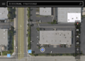
GPS position
GPS with date


Achievements
McKay earned the Consecutive geohash achievement
|