Difference between revisions of "2016-06-21 52 1"
From Geohashing
imported>Sourcerer (→Planning) |
imported>Sourcerer m ([live picture] Arrived. [http://www.openstreetmap.org/?lat=52.38149285&lon=1.30332828&zoom=16&layers=B000FTF @52.3815,1.3033]) |
||
| Line 26: | Line 26: | ||
<gallery caption="Photo Gallery" widths="200px" heights="200px" perrow="3"> | <gallery caption="Photo Gallery" widths="200px" heights="200px" perrow="3"> | ||
| + | |||
| + | Image:2016-06-21_52_1_Sourcerer_1466547046530.jpg | Arrived. [http://www.openstreetmap.org/?lat=52.38149285&lon=1.30332828&zoom=16&layers=B000FTF @52.3815,1.3033] | ||
</gallery> | </gallery> | ||
Revision as of 22:12, 21 June 2016
| Tue 21 Jun 2016 in Norwich, UK: 52.3815434, 1.3031658 geohashing.info google osm bing/os kml crox |
Location
10 metres off a farm track, north of Weybread, Suffolk, UK.
Participants
Plans
One of two spanning midnight - 2016-06-21 52 1 - 2016-06-22 52 1 - ETA 23:20.
Expedition
Photos
- Photo Gallery
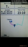
Arrived. @52.3815,1.3033

Achievements
Expeditions and Plans
| 2016-06-21 | ||
|---|---|---|
| Portland, Oregon | Jim | Farm land south of Hillsboro |
| Norwich, United Kingdom | Sourcerer | 10 metres off a farm track, north of Weybread, Suffolk, UK. |
Sourcerer's Expedition Links
2016-06-19 52 1 - 2016-06-21 52 1 - 2016-06-22 52 1 - KML file download of Sourcerer's expeditions for use with Google Earth.