Difference between revisions of "2016-06-25 -36 174"
imported>Nmoorenz (Created page with "Urban area for Auckland! See you there this afternoon!") |
imported>FippeBot m (Location) |
||
| (15 intermediate revisions by 2 users not shown) | |||
| Line 1: | Line 1: | ||
| − | + | ||
| − | + | <!-- If you did not specify these parameters in the template, please substitute appropriate values for IMAGE, LAT, LON, and DATE (YYYY-MM-DD format) | |
| + | |||
| + | [[Image:{{{image|IMAGE}}}|thumb|left]] | ||
| + | |||
| + | Remove this section if you don't want an image at the top (left) of your report. You should remove the "Image:" or "File:" | ||
| + | tag from your image file name, and replace the all upper-case word IMAGE in the above line. | ||
| + | |||
| + | And DON'T FORGET to add your expedition and the best photo you took to the gallery on the Main Page! We'd love to read your report, but that means we first have to discover it! :) | ||
| + | --> | ||
| + | {{meetup graticule | ||
| + | | lat=-36 | ||
| + | | lon=174 | ||
| + | | date=2016-06-25 | ||
| + | }} | ||
| + | |||
| + | <!-- edit as necessary --> | ||
| + | __NOTOC__ | ||
| + | |||
| + | == Location == | ||
| + | This is a rare urban hash for Auckland. | ||
| + | |||
| + | The location is on a small commercial road linking Post Haste Couriers and New Zealand Couriers. Each office is the place to go after getting a card-to-call on your doorstep. I've been to both, but never been through, so have not been to the location before. | ||
| + | |||
| + | == Participants == | ||
| + | <!-- who attended: If you link to your wiki user name in this section, your expedition will be picked up by the various statistics generated for geohashing. You may use three tildes ~ as a shortcut to automatically insert the user signature of the account you are editing with. | ||
| + | --> | ||
| + | |||
| + | * [[User:nmoorenz|nmoorenz]] | ||
| + | |||
| + | == Plans == | ||
| + | <!-- what were the original plans --> | ||
| + | |||
| + | The weather isn't so good, but a quick drive will get us to the geohash. | ||
| + | |||
| + | == Expedition == | ||
| + | <!-- how it all turned out. your narrative goes here. --> | ||
| + | |||
| + | I left home at about ten to four. My intention was to go from the north on Botha Rd, but ended up going along Rockfield since that's the way I usually travel to Onehunga or Royal Oak. This put me through the south gate from Mt Smart Rd. | ||
| + | |||
| + | I took a few photos. There are many more vans and trucks on the weekend than in the Google maps satellite view. There seemed to be no one around at all, but just before I left there was a roller door clanging closed somewhere. | ||
| + | |||
| + | It's a good thing that I came from the south since the Botha Rd gate was closed. I intended to leave that way but had to turn back. The NZ Couriers office closes at midday on a Saturday. | ||
| + | |||
| + | Successful visit, if a bit uneventful. | ||
| + | |||
| + | <!-- | ||
| + | == Tracklog == | ||
| + | if your GPS device keeps a log, you may post a link here --> | ||
| + | |||
| + | == Photos == | ||
| + | <!-- Insert pictures between the gallery tags using the following format: | ||
| + | Image:2012-##-## ## ## Alpha.jpg | Witty Comment | ||
| + | --> | ||
| + | <gallery perrow="5"> | ||
| + | Image:IMG_20160625.jpg|Screenshot from Geohash Droid, only 2.7km from home | ||
| + | Image:West_20160625_S36_E174.jpg|West from the hash, couriers clogging up my view | ||
| + | Image:South_20160625_S36_E174.jpg|South | ||
| + | Image:East_20160625_S36_E174.jpg|East | ||
| + | Image:North2_20160625_S36_E174.jpg|North 1 | ||
| + | Image:North1_20160625_S36_E174.jpg|North 2 | ||
| + | Image:Reached2_20160625_S36_E174.jpg|Reached | ||
| + | Image:Reached_20160625_S36_E174.jpg|Reached | ||
| + | </gallery> | ||
| + | |||
| + | == Achievements == | ||
| + | {{#vardefine:ribbonwidth|800px}} | ||
| + | <!-- Add any achievement ribbons you earned below, or remove this section --> | ||
| + | |||
| + | [[Category:Expeditions]] | ||
| + | [[Category:Coordinates reached]] | ||
| + | [[Category:Expeditions with photos]] | ||
| + | |||
| + | <!-- =============== USEFUL CATEGORIES FOLLOW ================ | ||
| + | Delete the next line ONLY if you have chosen the appropriate categories below. If you are unsure, don't worry. People will read your report and help you with the classification. | ||
| + | [[Category:New report]]--> | ||
| + | |||
| + | <!-- ==REQUEST FOR TWITTER BOT== Please leave either the New report or the Expedition planning category in as long as you work on it. This helps the twitter bot a lot with announcing the right outcome at the right moment. --> | ||
| + | |||
| + | <!-- Potential categories. Please include all the ones appropriate to your expedition | ||
| + | |||
| + | [[Category:Expedition planning]]--> | ||
| + | |||
| + | |||
| + | <!-- If all those plans are never acted upon, change [[Category:Expedition planning]] to [[Category:Not reached - Did not attempt]]. --> | ||
| + | |||
| + | <!-- An actual expedition: | ||
| + | [[Category:Expeditions]] | ||
| + | -- and one or more of -- | ||
| + | [[Category:Expeditions with photos]] | ||
| + | [[Category:Expeditions with videos]] | ||
| + | [[Category:Expedition without GPS]] | ||
| + | --> | ||
| + | |||
| + | <!-- if you reached your coords: | ||
| + | [[Category:Coordinates reached]] | ||
| + | --> | ||
| + | |||
| + | <!-- or if you failed :( | ||
| + | [[Category:Coordinates not reached]] | ||
| + | -- and a reason -- | ||
| + | When there is a natural obstacle between you and the target: | ||
| + | [[Category:Not reached - Mother Nature]] | ||
| + | |||
| + | When there is a man-made obstacle between you and the target: | ||
| + | [[Category:Not reached - No public access]] | ||
| + | |||
| + | When you failed get your GPS, car, bike or such to work: | ||
| + | [[Category:Not reached - Technology]] | ||
| + | |||
| + | When you went to an alternate location instead of the actual geohash: | ||
| + | [[Category:Not reached - Attended alternate location]] | ||
| + | |||
| + | (Don't forget to delete this final close comment marker) --> | ||
| + | {{location|NZ|AUK}} | ||
Latest revision as of 00:51, 16 August 2019
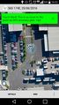
| Sat 25 Jun 2016 in -36,174: -36.9127565, 174.8084291 geohashing.info google osm bing/os kml crox |
Location
This is a rare urban hash for Auckland.
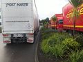
The location is on a small commercial road linking Post Haste Couriers and New Zealand Couriers. Each office is the place to go after getting a card-to-call on your doorstep. I've been to both, but never been through, so have not been to the location before.
Participants
Plans
The weather isn't so good, but a quick drive will get us to the geohash.
Expedition
I left home at about ten to four. My intention was to go from the north on Botha Rd, but ended up going along Rockfield since that's the way I usually travel to Onehunga or Royal Oak. This put me through the south gate from Mt Smart Rd.
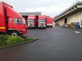
I took a few photos. There are many more vans and trucks on the weekend than in the Google maps satellite view. There seemed to be no one around at all, but just before I left there was a roller door clanging closed somewhere.
It's a good thing that I came from the south since the Botha Rd gate was closed. I intended to leave that way but had to turn back. The NZ Couriers office closes at midday on a Saturday.
Successful visit, if a bit uneventful.
Photos
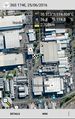
Screenshot from Geohash Droid, only 2.7km from home
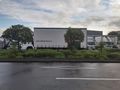
West from the hash, couriers clogging up my view
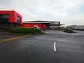
South
East
North 1

North 2
Reached
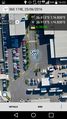
Reached


