Difference between revisions of "2016-06-28 60 17"
imported>FelixTheCat (Created page with "{{subst:Expedition |lat = 60 |lon = 17 |date = 2016-06-28 }}") |
imported>FelixTheCat |
||
| Line 1: | Line 1: | ||
| − | |||
| − | |||
| − | |||
| − | |||
| − | |||
| − | |||
| − | |||
| − | |||
| − | |||
| − | |||
{{meetup graticule | {{meetup graticule | ||
| lat=60 | | lat=60 | ||
| Line 15: | Line 5: | ||
}} | }} | ||
| − | |||
__NOTOC__ | __NOTOC__ | ||
== Location == | == Location == | ||
| − | + | In a forest in Gävle, Sweden. | |
== Participants == | == Participants == | ||
| − | + | [[User:FelixTheCat|FelixTheCat]] ([[User talk:FelixTheCat|talk]]) | |
| − | |||
| − | == | + | == Expedition == |
| − | + | I had just arrived in Gävle, and this hashpoint seemed to easy to not attempt. It was a bit late in the evening, but luckily at this time there's still a lot of sunlight at such high latitudes in June. So after checking into my hotel and eating dinner I drove towards the forest on the East side of town. The road leading into the forest was quite narrow and full of potholes, rather unlike most roads in this country. I had about 3km to go on this road, which took a long time because I had to avoid all the bumps and holes trying not to smash my bumpers into the gravel. | |
| − | + | The hash turned out to be around 250m off the road, so I parked the car at the side of the road and walked into the forest. I had to navigate around puddles, fallen trees and thick bushes, but the main annoyance was the mosquitoes. There were huge swarms of them, and they couldn't believe their luck that such a large mammal came along who had forgotten to put on insect repellant... I quickly took a few pictures at the spot and then ran back to the car. | |
| − | |||
| − | + | Two important observations: | |
| − | + | #Even though mosquitoes are quite slow, it's not possible to outrun them. | |
| + | #If you want to avoid mosquitoes entering a car with you, it helps to not carry a large backpack. | ||
== Photos == | == Photos == | ||
| − | |||
| − | |||
| − | |||
<gallery perrow="5"> | <gallery perrow="5"> | ||
| + | Image:2016-06-28 60 17 FelixTheCat 1.JPG | The forest road. | ||
| + | Image:2016-06-28 60 17 FelixTheCat 2.JPG | The forest. About 250m ahead from here. | ||
| + | Image:2016-06-28 60 17 FelixTheCat 3.JPG | Almost there... | ||
| + | Image:2016-06-28 60 17 FelixTheCat 4.JPG | This is the spot. | ||
| + | Image:2016-06-28 60 17 FelixTheCat 5.png | GPS proof. | ||
| + | Image:2016-06-28 60 17 FelixTheCat 6.JPG | Lloyd posing at the hash, unfazed by the mosquitoes. Guess they don't like miniature horses. | ||
</gallery> | </gallery> | ||
== Achievements == | == Achievements == | ||
{{#vardefine:ribbonwidth|800px}} | {{#vardefine:ribbonwidth|800px}} | ||
| − | + | {{land geohash | |
| − | + | | latitude = 60 | |
| − | + | | longitude = 17 | |
| − | + | | date = 2016-06-28 | |
| − | [[ | + | | name = [[User:FelixTheCat|FelixTheCat]] ([[User talk:FelixTheCat|talk]]) |
| − | + | }} | |
| − | |||
| − | |||
| − | |||
| − | |||
| − | [[ | ||
| − | |||
| − | |||
| − | |||
| − | |||
[[Category:Expeditions]] | [[Category:Expeditions]] | ||
| − | |||
[[Category:Expeditions with photos]] | [[Category:Expeditions with photos]] | ||
| − | |||
| − | |||
| − | |||
| − | |||
| − | |||
[[Category:Coordinates reached]] | [[Category:Coordinates reached]] | ||
| − | |||
| − | |||
| − | |||
| − | |||
| − | |||
| − | |||
| − | |||
| − | |||
| − | |||
| − | |||
| − | |||
| − | |||
| − | |||
| − | |||
| − | |||
| − | |||
| − | |||
| − | |||
Revision as of 10:35, 2 July 2016
| Tue 28 Jun 2016 in 60,17: 60.7241148, 17.2321891 geohashing.info google osm bing/os kml crox |
Location
In a forest in Gävle, Sweden.
Participants
Expedition
I had just arrived in Gävle, and this hashpoint seemed to easy to not attempt. It was a bit late in the evening, but luckily at this time there's still a lot of sunlight at such high latitudes in June. So after checking into my hotel and eating dinner I drove towards the forest on the East side of town. The road leading into the forest was quite narrow and full of potholes, rather unlike most roads in this country. I had about 3km to go on this road, which took a long time because I had to avoid all the bumps and holes trying not to smash my bumpers into the gravel.
The hash turned out to be around 250m off the road, so I parked the car at the side of the road and walked into the forest. I had to navigate around puddles, fallen trees and thick bushes, but the main annoyance was the mosquitoes. There were huge swarms of them, and they couldn't believe their luck that such a large mammal came along who had forgotten to put on insect repellant... I quickly took a few pictures at the spot and then ran back to the car.
Two important observations:
- Even though mosquitoes are quite slow, it's not possible to outrun them.
- If you want to avoid mosquitoes entering a car with you, it helps to not carry a large backpack.
Photos
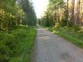
The forest road.
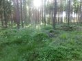
The forest. About 250m ahead from here.
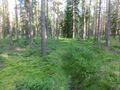
Almost there...
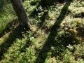
This is the spot.
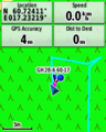
GPS proof.
Lloyd posing at the hash, unfazed by the mosquitoes. Guess they don't like miniature horses.


Achievements
FelixTheCat (talk) earned the Land geohash achievement
|