Difference between revisions of "2016-07-06 38 -121"
imported>Patrick |
imported>FippeBot m (Location) |
||
| (One intermediate revision by one other user not shown) | |||
| Line 26: | Line 26: | ||
<gallery caption="Pictures" widths="300px" heights="300px" perrow="3"> | <gallery caption="Pictures" widths="300px" heights="300px" perrow="3"> | ||
File:0706161313d.jpg|[[User:Patrick|Patrick]] at the point | File:0706161313d.jpg|[[User:Patrick|Patrick]] at the point | ||
| + | File:Screenshot 2016-07-06-13-13-19.png| Proof via the Geohash Droid app | ||
</gallery> | </gallery> | ||
| Line 31: | Line 32: | ||
[[Category:Expeditions with photos]] | [[Category:Expeditions with photos]] | ||
[[Category:Coordinates reached]] | [[Category:Coordinates reached]] | ||
| + | {{location|US|CA|PA}} | ||
Latest revision as of 01:59, 7 August 2019
| Wed 6 Jul 2016 in 38,-121: 38.9576908, -121.4051014 geohashing.info google osm bing/os kml crox |
About
38.9576908, -121.4051014, a Retrohash from the previous day, 2016-07-05
The coordinates in the Sacramento graticule are in Woodland, directly on County Road 101, also known as Harry Lorenzo Ave.
The Journey
Patrick, having taken several years off from geohashing, saw that YESTERDAY's hash was within a reasonable distance from his place. Having decided to switch his place to the place that was yesterday's place, he did just that.
This place was kind of what you would expect in this agricultural area in July - dusty, gravel road - with the exception that it was a very comfortable temperature about 15 degrees cooler than normal.
Being new to this graticule, I am encouraged that I can earn a Necromamcy Ribbon for bringing it back from the dead, even though this is not currently a "thing".
Pictures
- Pictures
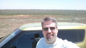
Patrick at the point
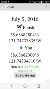
Proof via the Geohash Droid app

