Difference between revisions of "2016-08-02 52 1"
From Geohashing
imported>Sourcerer m (→Plans) |
imported>Sourcerer m ([live picture] Arrived. [http://www.openstreetmap.org/?lat=52.15798974&lon=1.42416179&zoom=16&layers=B000FTF @52.1580,1.4242]) |
||
| Line 24: | Line 24: | ||
== Photos == | == Photos == | ||
<gallery caption="Photo Gallery" widths="200px" heights="200px" perrow="3"> | <gallery caption="Photo Gallery" widths="200px" heights="200px" perrow="3"> | ||
| + | |||
| + | Image:2016-08-02_52_1_Sourcerer_1470175898236.jpg | Arrived. [http://www.openstreetmap.org/?lat=52.15798974&lon=1.42416179&zoom=16&layers=B000FTF @52.1580,1.4242] | ||
</gallery> | </gallery> | ||
Revision as of 22:13, 2 August 2016
| Tue 2 Aug 2016 in Norwich, UK: 52.1579934, 1.4241637 geohashing.info google osm bing/os kml crox |
Location
A field between Campsea Ashe and Blaxhall, Suffolk, UK.
Participants
Plans
One of two spanning midnight - 2016-08-02 52 1 - 2016-08-03 52 1 - ETA 23:15.
Expedition
Photos
- Photo Gallery
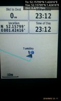
Arrived. @52.1580,1.4242

Achievements
Expeditions and Plans
| 2016-08-02 | ||
|---|---|---|
| Düsseldorf, Germany | pah, NB's mom | On a dog playing lawn in Rheydt. |
| Norwich, United Kingdom | Sourcerer | A field between Campsea Ashe and Blaxhall, Suffolk, UK. |
Sourcerer's Expedition Links
2016-07-31 52 1 - 2016-08-02 52 1 - 2016-08-03 52 1 - KML file download of Sourcerer's expeditions for use with Google Earth.