Difference between revisions of "2016-08-04 52 1"
From Geohashing
imported>Sourcerer m (→New expedition) |
imported>Sourcerer m (→Expedition) |
||
| Line 21: | Line 21: | ||
== Expedition == | == Expedition == | ||
| − | This was easy until it | + | This was easy until it wasn't. 8 metres from the hashpoint, a fence and deep ditch blocked the way. On the walk my footwear partially failed. Not the most satisfactory expedition. 3G seemed to be working but I was getting wiki errors. |
== Photos == | == Photos == | ||
Revision as of 00:13, 5 August 2016
| Thu 4 Aug 2016 in Norwich, UK: 52.3230370, 1.4682522 geohashing.info google osm bing/os kml crox |
Location
A field perimeter and footpath north of Walpole, Suffolk, UK.
Participants
Plans
One of two spanning midnight - 2016-08-04 52 1 - 2016-08-05 52 1 - ETA 22:50.
Expedition
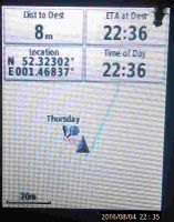
This was easy until it wasn't. 8 metres from the hashpoint, a fence and deep ditch blocked the way. On the walk my footwear partially failed. Not the most satisfactory expedition. 3G seemed to be working but I was getting wiki errors.
Photos
- Photo Gallery
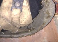
Footwear failure
Prof of Fail
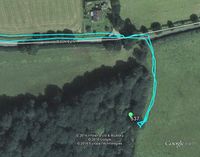
Google Earth Track


Achievements
Expeditions and Plans
| 2016-08-04 | ||
|---|---|---|
| Seattle, Washington | Thomcat | In front of the Neptune Society, a cremation service in Lynnwood. |
| Mannheim, Germany | DODO | A field next to the bridge of Speyer (on the right (and by that wrong) side... |
| Kassel, Germany | GeorgDerReisende | The hash lay on the back side of a building in Kassel-Rothenditmold. |
| Norwich, United Kingdom | Sourcerer | A field perimeter and footpath north of Walpole, Suffolk, UK. |
Sourcerer's Expedition Links
2016-08-03 52 1 - 2016-08-04 52 1 - 2016-08-05 52 1 - KML file download of Sourcerer's expeditions for use with Google Earth.