Difference between revisions of "2016-08-03 43 -85"
imported>Mcbaneg (Created page with "<!-- If you did not specify these parameters in the template, please substitute appropriate values for IMAGE, LAT, LON, and DATE (YYYY-MM-DD format) {{{image|dummy.jpg}}}|...") |
imported>FippeBot m (Location) |
||
| Line 61: | Line 61: | ||
[[Category:Expeditions with photos]] | [[Category:Expeditions with photos]] | ||
[[Category:Coordinates reached]] | [[Category:Coordinates reached]] | ||
| + | {{location|US|MI|KN}} | ||
Latest revision as of 01:09, 16 August 2019
| Wed 3 Aug 2016 in 43,-85: 43.0651375, -85.4082529 geohashing.info google osm bing/os kml crox |
Location
Saul Lake Bog Nature Preserve, Rockford, MI
Participants
Expedition
This was a very pleasant hash at the edge of a nature preserve. The preserve is not very well marked from the road but its web page has pretty good directions; you end up driving down what looks like a private driveway, then turning onto a two-track woods road that leads to a gravel parking area. The two girls drove and this gave them their first experience driving on woods roads.
The path through the preserve led pretty close to the hashpoint, and when it came time to bushwhack the terrain was accommodating. We were able to get a successful reading just at the edge of a swampy area in open woods.
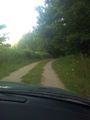
Approach road to preserve.
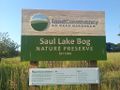
Sign at parking area.
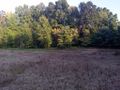
View toward hashpoint from path.
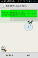
Proof.
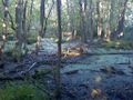
View E from hashpoint.
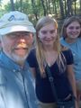
Grins. Notice mosquito caught between arrival and departure on G's DEET-coated cheek.
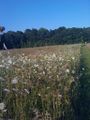
Preserve path. That's a lot of Queen Anne's lace.


