Difference between revisions of "2016-08-31 51 9"
imported>GeorgDerReisende (new report) |
imported>GeorgDerReisende (expedition report for Calden-Westuffeln) |
||
| Line 1: | Line 1: | ||
| − | |||
| − | |||
| − | |||
| − | |||
| − | |||
| − | |||
| − | |||
| − | |||
| − | |||
| − | |||
{{meetup graticule | {{meetup graticule | ||
| lat=51 | | lat=51 | ||
| Line 19: | Line 9: | ||
== Location == | == Location == | ||
| − | + | ||
| + | The hash lay on a field near Westuffeln. | ||
== Participants == | == Participants == | ||
| − | + | ||
| − | + | [[User:GeorgDerReisende|GeorgDerReisende]] | |
== Plans == | == Plans == | ||
| − | + | ||
| + | Today I wanted to take the bus. | ||
== Expedition == | == Expedition == | ||
| − | |||
| − | + | I took the tram 3 and the buses 100 and 130 to Westuffeln. And walked to the hashfield. Arriving there I noticed, that the hash was 10 meters onto the field. The field smelled a little bit like liquid manure, but looked dry. I tried to step on it and it seemed possible to walk there. I walked to the hash and for a moment I had a zero meter mark, but suddenly I heard a tractor coming around. I didn't want to be seen there and ran back to the field way. There I took the usual photos. Walked back to the village and traveled home. | |
| − | |||
== Photos == | == Photos == | ||
| − | |||
| − | |||
| − | |||
<gallery perrow="5"> | <gallery perrow="5"> | ||
| + | Image:2016-08-31 51 9 GeorgDerReisende 2968.jpg | arriving by bus | ||
| + | Image:2016-08-31 51 9 GeorgDerReisende 2970.jpg | this street leads to the hash | ||
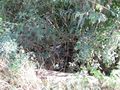
| + | Image:2016-08-31 51 9 GeorgDerReisende 2984.jpg | the hash from the wrong side | ||
| + | Image:2016-08-31 51 9 GeorgDerReisende 2985.jpg | a brook nearby | ||
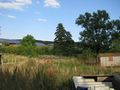
| + | Image:2016-08-31 51 9 GeorgDerReisende 2986.jpg | the field of hash | ||
| + | Image:2016-08-31 51 9 GeorgDerReisende 2988.jpg | proof | ||
| + | Image:2016-08-31 51 9 GeorgDerReisende 2989.jpg | proof of dance | ||
| + | Image:2016-08-31 51 9 GeorgDerReisende 2990.jpg | looking west | ||
| + | Image:2016-08-31 51 9 GeorgDerReisende 2991.jpg | north | ||
| + | Image:2016-08-31 51 9 GeorgDerReisende 2992.jpg | east | ||
| + | Image:2016-08-31 51 9 GeorgDerReisende 2993.jpg | south | ||
| + | Image:2016-08-31 51 9 GeorgDerReisende 2994.jpg | the geohasher | ||
</gallery> | </gallery> | ||
| Line 45: | Line 44: | ||
<!-- Add any achievement ribbons you earned below, or remove this section --> | <!-- Add any achievement ribbons you earned below, or remove this section --> | ||
| − | + | {{Public transport geohash | latitude = 51 | longitude = 9 | date = 2016-08-31 | busline = tram 3 and bus 100/130 | name = GeorgDerReisende }} | |
| − | |||
| − | |||
| − | + | [[Category:Expeditions]] | |
| − | + | [[Category:Expeditions with photos]] | |
| − | |||
| − | |||
| − | |||
| − | |||
| − | |||
| − | |||
| − | |||
| − | |||
| − | |||
| − | |||
| − | |||
| − | |||
| − | |||
| − | |||
[[Category:Coordinates reached]] | [[Category:Coordinates reached]] | ||
| − | |||
| − | |||
| − | |||
| − | |||
| − | |||
| − | |||
| − | |||
| − | |||
| − | |||
| − | |||
| − | |||
| − | |||
| − | |||
| − | |||
| − | |||
| − | |||
| − | |||
| − | |||
Revision as of 13:12, 1 September 2016
| Wed 31 Aug 2016 in 51,9: 51.4297402, 9.3246027 geohashing.info google osm bing/os kml crox |
Location
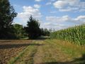
The hash lay on a field near Westuffeln.
Participants
Plans
Today I wanted to take the bus.
Expedition
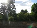
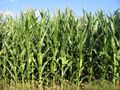
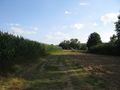
I took the tram 3 and the buses 100 and 130 to Westuffeln. And walked to the hashfield. Arriving there I noticed, that the hash was 10 meters onto the field. The field smelled a little bit like liquid manure, but looked dry. I tried to step on it and it seemed possible to walk there. I walked to the hash and for a moment I had a zero meter mark, but suddenly I heard a tractor coming around. I didn't want to be seen there and ran back to the field way. There I took the usual photos. Walked back to the village and traveled home.
Photos
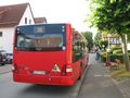
arriving by bus
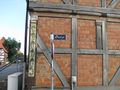
this street leads to the hash
the hash from the wrong side
a brook nearby
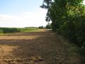
the field of hash
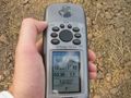
proof
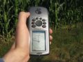
proof of dance
looking west
north
east
south
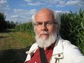
the geohasher


Achievements
GeorgDerReisende earned the Public transport geohash achievement
|