Difference between revisions of "2016-09-10 42 -85"
From Geohashing
imported>Mcbaneg (Created page with "<!-- If you did not specify these parameters in the template, please substitute appropriate values for IMAGE, LAT, LON, and DATE (YYYY-MM-DD format) {{{image|dummy.jpg}}}|...") |
imported>FippeBot m (Location) |
||
| Line 52: | Line 52: | ||
[[Category:Expeditions with photos]] | [[Category:Expeditions with photos]] | ||
[[Category:Coordinates reached]] | [[Category:Coordinates reached]] | ||
| + | {{location|US|MI|OT}} | ||
Latest revision as of 01:25, 16 August 2019
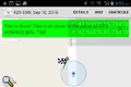
| Sat 10 Sep 2016 in 42,-85: 42.9475927, -85.7841626 geohashing.info google osm bing/os kml crox |
Location
West side of Kenowa Ave, Grand Rapids, MI
Participants
Expedition
Just off the road in a lightly settled, still somewhat rural, area on the southwest edge of the city. Rebekah hasn't had much driving practice lately and this wasn't very far away, so she agreed to go.
The hashpoint was at the front edge of the lawn of a house that looked well-kept but not obviously inhabited. There was a giant maple tree nearby that confused the GPS; most of my screenshots show the blue dot on the east side of the road but we were definitely on the west.
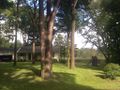
View E from hashpoint.

Grins.
Proof.
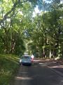
Hashmobile and driver.


