Difference between revisions of "2016-09-29 47 -120"
From Geohashing
imported>Thomcat ([live picture]125 miles [http://www.openstreetmap.org/?lat=47.17946460&lon=-120.83918980&zoom=16&layers=B000FTF @47.1795,-120.8392]) |
imported>FippeBot m (Location) |
||
| (3 intermediate revisions by one other user not shown) | |||
| Line 1: | Line 1: | ||
| − | |||
| − | |||
| − | |||
| − | |||
| − | |||
| − | |||
| − | |||
| − | |||
| − | |||
| − | |||
{{meetup graticule | {{meetup graticule | ||
| lat=47 | | lat=47 | ||
| lon=-120 | | lon=-120 | ||
| date=2016-09-29 | | date=2016-09-29 | ||
| + | | graticule_name=Wenatchee | ||
| + | | graticule_link=Wenatchee, Washington | ||
}} | }} | ||
| Line 19: | Line 11: | ||
== Location == | == Location == | ||
| − | + | On a highway northeast of Cle Elum | |
== Participants == | == Participants == | ||
| − | + | * [[User:Thomcat|Thomcat]] | |
| − | |||
| − | |||
| − | |||
== Expedition == | == Expedition == | ||
| − | + | I got out of town much later than I had planned, but an advanced gander at my trip across the state showed one geohash that would be on the way. | |
| + | *Looks reachable! -- [[User:Thomcat|Thomcat]] ([[User talk:Thomcat|talk]]) [http://www.openstreetmap.org/?lat=47.68569970&lon=-122.32375090&zoom=16&layers=B000FTF @47.6857,-122.3238] 08:28, 29 September 2016 (PDT) | ||
| − | + | I plugged the coordinates into the Prius map and went for a 125 mile drive. Once I was close, the geohashdroid app showed the point to be considerably off the road, which was interesting. See below for an example. | |
| − | + | ||
| − | + | Reaching the Prius coordinates, I stopped and parked nearby. The coordinates and map and arrow all lined up, and the green "you're there" light was given. Another success for the Wenatchee graticule! | |
== Photos == | == Photos == | ||
| − | |||
| − | |||
| − | |||
<gallery perrow="5"> | <gallery perrow="5"> | ||
| Line 45: | Line 32: | ||
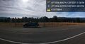
Image:2016-09-29_47_-120_thomcat_1475170062272.jpg|125 miles [http://www.openstreetmap.org/?lat=47.17946460&lon=-120.83918980&zoom=16&layers=B000FTF @47.1795,-120.8392] | Image:2016-09-29_47_-120_thomcat_1475170062272.jpg|125 miles [http://www.openstreetmap.org/?lat=47.17946460&lon=-120.83918980&zoom=16&layers=B000FTF @47.1795,-120.8392] | ||
| + | |||
| + | Image:2016-09-29_47_-120_thomcat_1475170102748.jpg|Flag a little off [http://www.openstreetmap.org/?lat=47.17956840&lon=-120.83919990&zoom=16&layers=B000FTF @47.1796,-120.8392] | ||
| + | |||
| + | Image:2016-09-29_47_-120_thomcat_1475170210902.jpg|Sign [http://www.openstreetmap.org/?lat=47.17952780&lon=-120.83908300&zoom=16&layers=B000FTF @47.1795,-120.8391] | ||
</gallery> | </gallery> | ||
| Line 51: | Line 42: | ||
<!-- Add any achievement ribbons you earned below, or remove this section --> | <!-- Add any achievement ribbons you earned below, or remove this section --> | ||
| − | |||
| − | |||
| − | |||
| − | |||
| − | |||
| − | |||
| − | |||
| − | |||
| − | |||
| − | |||
| − | |||
| − | |||
| − | |||
| − | |||
[[Category:Expeditions]] | [[Category:Expeditions]] | ||
| − | |||
[[Category:Expeditions with photos]] | [[Category:Expeditions with photos]] | ||
| − | |||
| − | |||
| − | |||
| − | |||
| − | |||
[[Category:Coordinates reached]] | [[Category:Coordinates reached]] | ||
| − | + | {{location|US|WA|KT}} | |
| − | |||
| − | |||
| − | |||
| − | |||
| − | |||
| − | |||
| − | |||
| − | |||
| − | |||
| − | |||
| − | |||
| − | |||
| − | |||
| − | |||
| − | |||
| − | |||
| − | |||
Latest revision as of 02:11, 7 August 2019
| Thu 29 Sep 2016 in Wenatchee: 47.1795573, -120.8391982 geohashing.info google osm bing/os kml crox |
Location
On a highway northeast of Cle Elum
Participants
Expedition
I got out of town much later than I had planned, but an advanced gander at my trip across the state showed one geohash that would be on the way.
- Looks reachable! -- Thomcat (talk) @47.6857,-122.3238 08:28, 29 September 2016 (PDT)
I plugged the coordinates into the Prius map and went for a 125 mile drive. Once I was close, the geohashdroid app showed the point to be considerably off the road, which was interesting. See below for an example.
Reaching the Prius coordinates, I stopped and parked nearby. The coordinates and map and arrow all lined up, and the green "you're there" light was given. Another success for the Wenatchee graticule!
Photos
Pano @47.1796,-120.8393

125 miles @47.1795,-120.8392
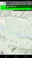
Flag a little off @47.1796,-120.8392
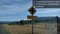
Sign @47.1795,-120.8391


