Difference between revisions of "2016-10-08 -19 146"
imported>Felix Dance (Added expedition details) |
imported>Felix Dance (Midnight geohash for camping) |
||
| Line 84: | Line 84: | ||
| distance = about 10km extra, 110kms for the day | | distance = about 10km extra, 110kms for the day | ||
| bothways = true | | bothways = true | ||
| + | | image = Geohash 2016-10-08 -19 146 Felix.JPG | ||
| + | }} | ||
| + | |||
| + | {{Midnight geohash | ||
| + | |||
| + | | latitude = -19 | ||
| + | | longitude = 146 | ||
| + | | date = 2016-10-08 | ||
| + | | name = [[User:Felix Dance|Felix Dance]] | ||
| image = Geohash 2016-10-08 -19 146 Felix.JPG | | image = Geohash 2016-10-08 -19 146 Felix.JPG | ||
}} | }} | ||
Revision as of 03:33, 9 October 2016
| Sat 8 Oct 2016 in -19,146: -19.9155333, 146.7241651 geohashing.info google osm bing/os kml crox |
Location
In the bush on a low hill on pastoral land. Somewhat near Charters Towers.
Participants
Expedition
I saw this hash as I was leaving Townsville. I'd woken up on Magnetic Island and had dragged my feet having a coffee, getting on the ferry back to the mainland and going to the shops, so I believed it was way too far away for me that day, despite being quite close to my route. It was 110 kms off and I was already approaching the afternoon.
After a leisurely ride I stopped for a late lunch at Reid Creek and had another look. Only 48kms away. I could do this.
I immediately got up and rode off. I didn't stop after that. It was only a few hours before I'd turned off the Charters Towers road into the tiny town of Mongolia. The sun lowered towards the horizon. I rode on for another 5 kms or so, then hit the dirt tracks behind some farms.
These tracks steadily got crappier and crappier. Soon I was pushing my bike through sandy creek beds and over barbed wire fences. Again Google had invented roads where none existed (see 2016-10-05 -18 146).
Ignoring curious red kangaroos and self-herding cattle, I raced against the sunset. The dry bushland would be very hazardous to navigate at night, and I still had 2.3kms to go.
A few twists and log-dodgings and I was there. I took some photos and set up my tent directly over the hash. Some cattle looked on, but moved away. I cooked and ate dinner and fell asleep reading The New Yorker.
In the morning I packed up and continued on my way, taking about an hour to reach the road again. I punctured an Ortlieb pannier on my way out.
Photos
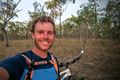
Me at the hash with my bike
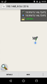
Phone GPS proof
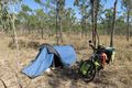
Waking up at the hash


Achievements
Felix Dance (talk) earned the Bicycle geohash achievement
|
Felix Dance earned the Midnight Geohash achievement
|