Difference between revisions of "2016-10-16 48 10"
imported>TheOneRing |
imported>TheOneRing |
||
| Line 27: | Line 27: | ||
== Photos == | == Photos == | ||
| − | + | <gallery perrow="5"> | |
| + | Image:20161016_48_10GPS.jpg|Coordinates reached | ||
| + | Image:20161016_48_10Info.jpg|Some more infos | ||
| + | Image:20161016_48_10Geohash.jpg|Here I am | ||
| + | Image:20161016_48_10Me.jpg|The hasher, the grin more stupid than usual | ||
| + | Image:20161016_48_10Picnic.jpg|Lunch | ||
| + | Image:20161016_48_10Surrounding.jpg|A panoramic view over the field at the geohash | ||
| + | Image:20161016_48_10Route.jpg|The route of my walk | ||
| + | </gallery> | ||
== Achievements == | == Achievements == | ||
| Line 36: | Line 44: | ||
[[Category:Expeditions]] | [[Category:Expeditions]] | ||
| + | [[Category:Expeditions with photos]] | ||
[[Category:Coordinates reached]] | [[Category:Coordinates reached]] | ||
Revision as of 22:17, 21 October 2016
| Sun 16 Oct 2016 in 48,10: 48.1472317, 10.9522689 geohashing.info google osm bing/os kml crox |
Location
The geohash is on a field near Walleshausen.
Who Went
TheOneRing - by public transport.
The Expedition
This geohash was not very far away, and easy to reach via train. I got up earlier than I planned and could therefore take one train earlier to Walleshausen. It took about 30min.
From the train station, my eTrex showed something like 2km as the bird flies. I took my time, walked along a street and enjoyed weather and landscape, respectively. I had to pass the geohash for the first time in a distance of about 1km, because in between there were not yet harvested fields. The street - later road, than farm track - made to larger curves and I had to pass the geohash again, when just 350m away.
Thereafter, there was a farm track which led directly to the geohash and I was lucky: the geohash itself was on a field, already harvested. It hadn't rained for days and the field was dry, not problems.
After taking the usual photographs, I had a small lunch and was thinking what to do next. Walking back to Walleshausen and taking a train back home, was an option but the weather was too nice and I wanted to walk more.
I decided to walk to the next train station (Geltendorf), which was approx. 10km from the geohash. I passed Kaltenberg, where once a year in July is a medieval festival (Kaltenberger Ritterturnier, sorry, only in German). At a bakery, I had a large cappucino to go for an energy boost. ;)
After 90min, I reached Geltendorf, which is a remarkable large (or better long) city, as I crossed it entirely from North to South to get to the train station.
After a while, I took the next train home, and had there another cup of coffee.
Photos
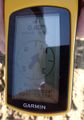
Coordinates reached
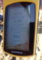
Some more infos
Here I am
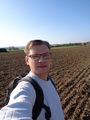
The hasher, the grin more stupid than usual
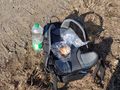
Lunch
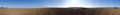
A panoramic view over the field at the geohash
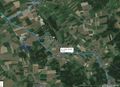
The route of my walk


Achievements
TheOneRing earned the Land geohash achievement
|
TheOneRing earned the Public transport geohash achievement
|
TheOneRing earned the Picnic achievement
|