Difference between revisions of "2016-10-22 49 8"
imported>DODO (→Photos) |
imported>DODO (→Achievements) |
||
| Line 58: | Line 58: | ||
== Achievements == | == Achievements == | ||
| − | |||
| − | |||
| − | + | {{land geohash | |
| − | + | | latitude = 49 | |
| − | + | | longitude = 8 | |
| + | | date = 2016-10-22 | ||
| + | | name = DODO | ||
| + | }} | ||
| − | |||
| − | |||
| − | |||
| − | |||
| − | |||
| − | |||
| − | |||
| − | |||
| − | |||
| − | |||
[[Category:Expeditions]] | [[Category:Expeditions]] | ||
| − | |||
| − | |||
| − | |||
| − | |||
| − | |||
| − | |||
| − | |||
[[Category:Coordinates reached]] | [[Category:Coordinates reached]] | ||
| − | |||
| − | |||
| − | |||
| − | |||
| − | |||
| − | |||
| − | |||
| − | |||
| − | |||
| − | |||
| − | |||
| − | |||
| − | |||
| − | |||
| − | |||
| − | |||
| − | |||
| − | |||
Revision as of 16:08, 24 October 2016
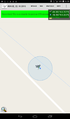
| Sat 22 Oct 2016 in 49,8: 49.7850786, 8.2017904 geohashing.info google osm bing/os kml crox |
Location
At the edge of a rivulet near Gau-Odernheim.
Participants
Plans
Tomorrow is the 80th birthday of my mother and so I'm going to drive to Neuwied today. I'll have a short detour to collect this nice hash.
Expedition
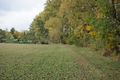
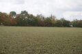
Just as planned. I left the motorway A61 at Kreuz Alley and drove 8 kilometers to Gau-Odernheim. I left my car near the church and walked in the direction of the hash. I came along a sign, describing that near Gau-Odernhein is the biggest appearance of wild tulips in Germany, but unfortunately it is not the season for tulips now. I reached the rivulet Salz and followed it for some 200 meters.Then I almost bumped into the hash, just one or two meters of my path in the field.
I returned just the same way and after less than half an hour I had returned to the A61 and continued my journey to my mothers birthday. We had a very nice weekend with much cake, some walking, a lot of talking, playing, cooking and eating.
Tracklog
8 kilometers by car and 1,5 kilometers of walking. Another 8 kilometers of driving weren't recorded, but were just the same way back.
Photos
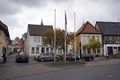
where I left my car
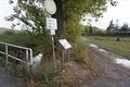
Selz and tulip-sign
wine
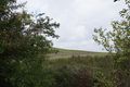
view to the hash
view from the hash in opposite direction
proof
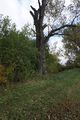
hash-tree
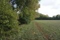
hash-field (the car is at the church tower in the background

hasher


Achievements
DODO earned the Land geohash achievement
|