Difference between revisions of "2016-12-04 51 9"
From Geohashing
imported>GeorgDerReisende (new report) |
imported>GeorgDerReisende (expedition report for Fuldabrück-Dittershausen) |
||
| Line 1: | Line 1: | ||
| − | |||
| − | |||
| − | |||
| − | |||
| − | |||
| − | |||
| − | |||
| − | |||
| − | |||
| − | |||
{{meetup graticule | {{meetup graticule | ||
| lat=51 | | lat=51 | ||
| Line 19: | Line 9: | ||
== Location == | == Location == | ||
| − | + | ||
| + | The hash lay on the sports field of Dittershausen. | ||
== Participants == | == Participants == | ||
| − | + | ||
| − | + | [[User:GeorgDerReisende|GeorgDerReisende]] | |
== Plans == | == Plans == | ||
| − | + | ||
| + | A little bit hitchhiking and a little bit walking. | ||
== Expedition == | == Expedition == | ||
| − | |||
| − | + | Short report: I arrived at the bridge of Dennhausen and walked to the hash. Afterwards I made a walk around Dittershausen. | |
| − | |||
== Photos == | == Photos == | ||
| Line 39: | Line 29: | ||
--> | --> | ||
<gallery perrow="5"> | <gallery perrow="5"> | ||
| + | Image:2016-12-04 51 9 GeorgDerReisende 2030.jpg | the bridge across the river Fulda in Dennhausen | ||
| + | Image:2016-12-04 51 9 GeorgDerReisende 2044.jpg | walk to the hash | ||
| + | Image:2016-12-04 51 9 GeorgDerReisende 2045.jpg | frozen salad | ||
| + | Image:2016-12-04 51 9 GeorgDerReisende 2047.jpg | frozen field | ||
| + | Image:2016-12-04 51 9 GeorgDerReisende 2066.jpg | the hash is near | ||
| + | Image:2016-12-04 51 9 GeorgDerReisende 2069.jpg | proof | ||
| + | Image:2016-12-04 51 9 GeorgDerReisende 2070.jpg | the north | ||
| + | Image:2016-12-04 51 9 GeorgDerReisende 2071.jpg | the east | ||
| + | Image:2016-12-04 51 9 GeorgDerReisende 2072.jpg | the south | ||
| + | Image:2016-12-04 51 9 GeorgDerReisende 2073.jpg | the west | ||
| + | Image:2016-12-04 51 9 GeorgDerReisende 2074.jpg | the geohasher | ||
</gallery> | </gallery> | ||
| Line 45: | Line 46: | ||
<!-- Add any achievement ribbons you earned below, or remove this section --> | <!-- Add any achievement ribbons you earned below, or remove this section --> | ||
| − | + | {{Thumbs Up | latitude = 51 | longitude = 9 | date = 2016-12-04 | name = GeorgDerReisende }} | |
| − | |||
| − | |||
| − | + | [[Category:Expeditions]] | |
| − | + | [[Category:Expeditions with photos]] | |
| − | |||
| − | [[Category: | ||
| − | |||
| − | |||
| − | |||
| − | |||
| − | |||
| − | |||
| − | |||
| − | |||
| − | |||
| − | |||
| − | |||
| − | |||
[[Category:Coordinates reached]] | [[Category:Coordinates reached]] | ||
| − | |||
| − | |||
| − | |||
| − | |||
| − | |||
| − | |||
| − | |||
| − | |||
| − | |||
| − | |||
| − | |||
| − | |||
| − | |||
| − | |||
| − | |||
| − | |||
| − | |||
| − | |||
Revision as of 17:48, 5 December 2016
| Sun 4 Dec 2016 in 51,9: 51.2556875, 9.4863504 geohashing.info google osm bing/os kml crox |
Location
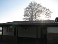
The hash lay on the sports field of Dittershausen.
Participants
Plans
A little bit hitchhiking and a little bit walking.
Expedition
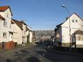
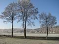
Short report: I arrived at the bridge of Dennhausen and walked to the hash. Afterwards I made a walk around Dittershausen.
Photos
the bridge across the river Fulda in Dennhausen
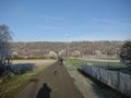
walk to the hash
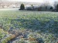
frozen salad
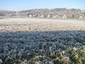
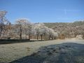
frozen field
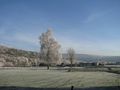
the hash is near
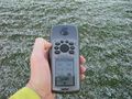
proof
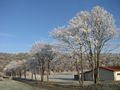
the north
the east
the south
the west
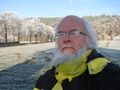
the geohasher


Achievements
GeorgDerReisende earned the Thumbs Up Geohash Achievement
|