Difference between revisions of "2016-12-29 52 6"
imported>FelixTheCat (Created page with "{{subst:Expedition |lat = 52 |lon = 6 |date = 2016-12-29 }}") |
imported>FelixTheCat |
||
| Line 1: | Line 1: | ||
| − | |||
| − | |||
| − | |||
| − | |||
| − | |||
| − | |||
| − | |||
| − | |||
| − | |||
| − | |||
{{meetup graticule | {{meetup graticule | ||
| lat=52 | | lat=52 | ||
| Line 14: | Line 4: | ||
| date=2016-12-29 | | date=2016-12-29 | ||
}} | }} | ||
| − | |||
| − | |||
__NOTOC__ | __NOTOC__ | ||
| − | |||
== Location == | == Location == | ||
| − | + | In a forest near Loenen, Gelderland province. | |
== Participants == | == Participants == | ||
| − | + | [[User:FelixTheCat|FelixTheCat]] ([[User talk:FelixTheCat|talk]]) | |
| − | |||
| − | == | + | == Expedition == |
| − | + | Today was very foggy all over the country, except in the far eastern corner where this geohash was. I decided to go on a trip to visit a couple of museums in the vicinity (including the royal palace near Apeldoorn) and see if the hash was reachable. | |
| − | + | The way there was rather uneventful, although visibility was pretty poor for most of the way. I reached the forest and had a nice walk through it in the crisp early morning air. The forest had a small stream running through it, which didn't look very interesting or even noteworthy, until it suddenly turned into a huge waterfall! Although not quite Niagara Falls, it is actually the tallest waterfall in the Netherlands at a whopping 15 metres. | |
| − | |||
| − | + | After about 1 km there was a railway line, without the usual fences and barriers because it's not in regular use anymore; the only user is the Veluwe Steam Engine Company which runs actual steam trains along this line for tourists. The hash was next to the tracks and quite easy to reach. My first hash in the Enschede graticule! | |
| − | |||
== Photos == | == Photos == | ||
| − | |||
| − | |||
| − | |||
<gallery perrow="5"> | <gallery perrow="5"> | ||
| + | Image:2016-12-29 52 6 FelixTheCat 1.JPG | The forest, in the still foggy morning air. Note the mighty river. | ||
| + | Image:2016-12-29 52 6 FelixTheCat 2.JPG | Here it turns into a roaring waterfall. | ||
| + | Image:2016-12-29 52 6 FelixTheCat 3.JPG | Just watch its magnificence! | ||
| + | Image:2016-12-29 52 6 FelixTheCat 4.JPG | The train tracks. No barriers or fences, just a "Beware of trains" sign. | ||
| + | Image:2016-12-29 52 6 FelixTheCat 5.JPG | The end of the river, before it flows underneath the tracks. | ||
| + | Image:2016-12-29 52 6 FelixTheCat 7.JPG | A shot of the hashpoint. | ||
| + | Image:2016-12-29 52 6 FelixTheCat 6.JPG | Lloyd posing with Harriet (who was visiting and joined us on this trip) | ||
| + | Image:2016-12-29 52 6 FelixTheCat 8.png | GPS proof. | ||
</gallery> | </gallery> | ||
== Achievements == | == Achievements == | ||
{{#vardefine:ribbonwidth|800px}} | {{#vardefine:ribbonwidth|800px}} | ||
| − | + | {{Minesweeper geohash | |
| − | + | | graticule = Utrecht, Netherlands | |
| − | + | | ranknumber = 5 | |
| − | + | | n = true | |
| − | + | | ne = true | |
| − | + | | e = true | |
| − | + | | w = true | |
| − | + | | sw = true | |
| − | + | | name = [[User:FelixTheCat|FelixTheCat]] ([[User talk:FelixTheCat|talk]]) | |
| − | + | }} | |
| − | |||
| − | |||
| − | |||
| − | |||
| − | |||
| − | |||
[[Category:Expeditions]] | [[Category:Expeditions]] | ||
| − | |||
[[Category:Expeditions with photos]] | [[Category:Expeditions with photos]] | ||
| − | |||
| − | |||
| − | |||
| − | |||
| − | |||
[[Category:Coordinates reached]] | [[Category:Coordinates reached]] | ||
| − | |||
| − | |||
| − | |||
| − | |||
| − | |||
| − | |||
| − | |||
| − | |||
| − | |||
| − | |||
| − | |||
| − | |||
| − | |||
| − | |||
| − | |||
| − | |||
| − | |||
| − | |||
Revision as of 18:48, 29 December 2016
| Thu 29 Dec 2016 in 52,6: 52.1366193, 6.0196567 geohashing.info google osm bing/os kml crox |
Location
In a forest near Loenen, Gelderland province.
Participants
Expedition
Today was very foggy all over the country, except in the far eastern corner where this geohash was. I decided to go on a trip to visit a couple of museums in the vicinity (including the royal palace near Apeldoorn) and see if the hash was reachable.
The way there was rather uneventful, although visibility was pretty poor for most of the way. I reached the forest and had a nice walk through it in the crisp early morning air. The forest had a small stream running through it, which didn't look very interesting or even noteworthy, until it suddenly turned into a huge waterfall! Although not quite Niagara Falls, it is actually the tallest waterfall in the Netherlands at a whopping 15 metres.
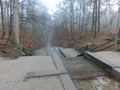
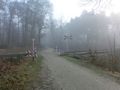
After about 1 km there was a railway line, without the usual fences and barriers because it's not in regular use anymore; the only user is the Veluwe Steam Engine Company which runs actual steam trains along this line for tourists. The hash was next to the tracks and quite easy to reach. My first hash in the Enschede graticule!
Photos
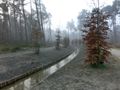
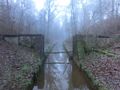
The forest, in the still foggy morning air. Note the mighty river.
Here it turns into a roaring waterfall.
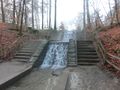
Just watch its magnificence!
The train tracks. No barriers or fences, just a "Beware of trains" sign.
The end of the river, before it flows underneath the tracks.
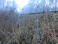
A shot of the hashpoint.
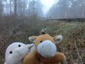
Lloyd posing with Harriet (who was visiting and joined us on this trip)
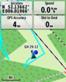
GPS proof.


Achievements
FelixTheCat (talk) achieved level 5 of the Minesweeper Geohash achievement
|