Difference between revisions of "2017-01-06 -38 144"
From Geohashing
imported>Pedalpusher m (→Achievements: fixed title) |
imported>Benkaiser (Initial edit, need to fix up photo links) |
||
| Line 24: | Line 24: | ||
<gallery perrow="7"> | <gallery perrow="7"> | ||
Image:2017-01-06 -38 144 selfie.jpg | Selfie | Image:2017-01-06 -38 144 selfie.jpg | Selfie | ||
| − | Image:2017-01-06 -38 144 | + | Image:2017-01-06 -38 144 panorama.jpg | Joelle at the hashpoint in a panorama |
| − | |||
Image:2017-01-06 -38 144 screenshot.png | Screenshot at hashpoint | Image:2017-01-06 -38 144 screenshot.png | Screenshot at hashpoint | ||
</gallery> | </gallery> | ||
| − | == Achievements == | + | == Achievements === |
* Land Geohash | * Land Geohash | ||
Revision as of 03:30, 9 January 2017
| Fri 6 Jan 2017 in -38,144: -38.2541694, 144.5852391 geohashing.info google osm bing/os kml crox |
Location
In a paddock near Queenscliffe
Participants
- Benjamin Kaiser
- Joelle
Expedition
We went for an afternoon drive to the geohash, visiting Queenscliffe before heading to the geohash on the way back. We took a back-road route to the geohash which probably wasn't the wisest. It went from gravel to sandy to rock to sandy to grass/rocky before finally turning back to gravel, had it been a wet day we would more than likely have been bogged out there.
Upon finding the point on the road perpendicular to the geohash (about 30m distance) we saw some other vehicles, perhaps some other geohashers. We decided to venture through the paddock from the south-side corner and walk to the hash-point.
Photos
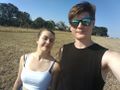
Selfie
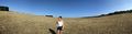
Joelle at the hashpoint in a panorama
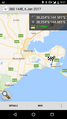
Screenshot at hashpoint


Achievements =
- Land Geohash