Difference between revisions of "2017-01-24 49 8"
imported>DODO (Created page with "{{subst:Expedition |lat = 49 |lon = 8 |date = 2017-01-24 }}") |
imported>FippeBot m (Location) |
||
| (One intermediate revision by one other user not shown) | |||
| Line 20: | Line 20: | ||
== Location == | == Location == | ||
<!-- where you've surveyed the hash to be --> | <!-- where you've surveyed the hash to be --> | ||
| − | + | In the forest between Hassloch and Geinsheim. | |
== Participants == | == Participants == | ||
<!-- who attended: If you link to your wiki user name in this section, your expedition will be picked up by the various statistics generated for geohashing. You may use three tildes ~ as a shortcut to automatically insert the user signature of the account you are editing with. | <!-- who attended: If you link to your wiki user name in this section, your expedition will be picked up by the various statistics generated for geohashing. You may use three tildes ~ as a shortcut to automatically insert the user signature of the account you are editing with. | ||
--> | --> | ||
| − | + | [[User:DODO|DODO]] | |
== Plans == | == Plans == | ||
<!-- what were the original plans --> | <!-- what were the original plans --> | ||
| + | Close enough to go there by car on my way to the office. | ||
== Expedition == | == Expedition == | ||
<!-- how it all turned out. your narrative goes here. --> | <!-- how it all turned out. your narrative goes here. --> | ||
| + | I left home at 7:15 in the morning and drove for 10,5 KM. I found a place where I could leave the car. From here it was just 1 KM to walk to the hash. It was still completely dark, but the forrest was partly frozen and so I could see enough. It was very quite and all I could here was the sound of my own steps and my breathing. After ten minutes I couldn't come closer to the hash on patches and had to walk into the forrest for 200 m. The ground was covered with waist-high grass, but that was easy to cross. No thorns, hardly any branches and the ground was mostly even. I danced a little and got a good enough shot. I tried to take some pictures, but I only had the bad camera of the tablet, and it was much to dark for that. | ||
| + | |||
| + | Quickly I returned to the car and drove to the office. | ||
== Tracklog == | == Tracklog == | ||
<!-- if your GPS device keeps a log, you may post a link here --> | <!-- if your GPS device keeps a log, you may post a link here --> | ||
| + | [https://www.komoot.de/tour/14058833 3KM walking] and 21 Km driving (no tracklog). | ||
== Photos == | == Photos == | ||
| Line 39: | Line 44: | ||
--> | --> | ||
<gallery perrow="5"> | <gallery perrow="5"> | ||
| + | Image:2017-01-24_49_8-1.jpg|some light against the sky | ||
| + | Image:2017-01-24_49_8-2.jpg|hardly enough to see the outline of the hasher | ||
| + | Image:2017-01-24_49_8-3.jpg|bright enough when I returned to the car | ||
| + | Image:2017-01-24_49_8-4.png|proof | ||
</gallery> | </gallery> | ||
| Line 44: | Line 53: | ||
{{#vardefine:ribbonwidth|800px}} | {{#vardefine:ribbonwidth|800px}} | ||
<!-- Add any achievement ribbons you earned below, or remove this section --> | <!-- Add any achievement ribbons you earned below, or remove this section --> | ||
| + | {{land geohash | ||
| + | | latitude = 49 | ||
| + | | longitude = 8 | ||
| + | | date = 2017-01-24 | ||
| + | | name = DODO | ||
| + | }} | ||
| − | + | {{consecutive geohash | |
| − | + | | count = 3 | |
| − | + | | latitude =50 | |
| − | + | | longitude = 7 | |
| − | + | | date = 2017-01-22 | |
| − | + | | name = DODO | |
| − | + | }} | |
| − | |||
| − | |||
| − | |||
| − | |||
| − | |||
| − | |||
[[Category:Expeditions]] | [[Category:Expeditions]] | ||
| − | |||
| − | |||
| − | |||
| − | |||
| − | |||
| − | |||
| − | |||
[[Category:Coordinates reached]] | [[Category:Coordinates reached]] | ||
| − | + | {{location|DE|RP|DÜW}} | |
| − | |||
| − | |||
| − | |||
| − | |||
| − | |||
| − | |||
| − | |||
| − | |||
| − | |||
| − | |||
| − | |||
| − | |||
| − | |||
| − | |||
| − | |||
| − | |||
| − | |||
Latest revision as of 02:03, 16 August 2019
| Tue 24 Jan 2017 in 49,8: 49.3304972, 8.2734371 geohashing.info google osm bing/os kml crox |
Location
In the forest between Hassloch and Geinsheim.
Participants
Plans
Close enough to go there by car on my way to the office.
Expedition
I left home at 7:15 in the morning and drove for 10,5 KM. I found a place where I could leave the car. From here it was just 1 KM to walk to the hash. It was still completely dark, but the forrest was partly frozen and so I could see enough. It was very quite and all I could here was the sound of my own steps and my breathing. After ten minutes I couldn't come closer to the hash on patches and had to walk into the forrest for 200 m. The ground was covered with waist-high grass, but that was easy to cross. No thorns, hardly any branches and the ground was mostly even. I danced a little and got a good enough shot. I tried to take some pictures, but I only had the bad camera of the tablet, and it was much to dark for that.
Quickly I returned to the car and drove to the office.
Tracklog
3KM walking and 21 Km driving (no tracklog).
Photos
some light against the sky

hardly enough to see the outline of the hasher
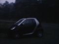
bright enough when I returned to the car
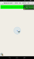
proof


Achievements
DODO earned the Land geohash achievement
|
DODO earned the Consecutive geohash achievement
|