Difference between revisions of "2017-04-08 49 8"
imported>DODO (Created page with "{{subst:Expedition |lat = 49 |lon = 8 |date = 2017-04-08 }}") |
imported>DODO |
||
| Line 20: | Line 20: | ||
== Location == | == Location == | ||
<!-- where you've surveyed the hash to be --> | <!-- where you've surveyed the hash to be --> | ||
| + | A meadow near Hanhofen | ||
== Participants == | == Participants == | ||
<!-- who attended: If you link to your wiki user name in this section, your expedition will be picked up by the various statistics generated for geohashing. You may use three tildes ~ as a shortcut to automatically insert the user signature of the account you are editing with. | <!-- who attended: If you link to your wiki user name in this section, your expedition will be picked up by the various statistics generated for geohashing. You may use three tildes ~ as a shortcut to automatically insert the user signature of the account you are editing with. | ||
--> | --> | ||
| + | [[User:DODO|DODO]] | ||
== Plans == | == Plans == | ||
<!-- what were the original plans --> | <!-- what were the original plans --> | ||
| + | To close, not to go. I wanted to go there by bike in the afternoon. | ||
== Expedition == | == Expedition == | ||
<!-- how it all turned out. your narrative goes here. --> | <!-- how it all turned out. your narrative goes here. --> | ||
| − | + | I started at home at half past 3. The weather was sunny and warm, and I had just 8 KM to ride, a perfect location for me and my bike. The only downer was that I had to drive to Koblenz this afternoon so I had not so much time and had to hurry a little. I lost my way in Hahnhofen for maybe 200 m, enough to disqualify for a tron achievemnet, but that would have been hardly possible anyway as I had to drive 50 m or so into the way to the hashmeadow. Next to the meadow was a bench. I left my bike there and walked the remaining 70 m into the meadow. No big deal. I took some pictures, and returned to the bench to wait the last 5 minutes until 4. As expected nobody else came (at least no hasher), and so I hurried back home. A great short ride before the drive thanks to geohashing. | |
== Tracklog == | == Tracklog == | ||
<!-- if your GPS device keeps a log, you may post a link here --> | <!-- if your GPS device keeps a log, you may post a link here --> | ||
| + | [https://www.komoot.de/tour/15317812 15 KM by bike] | ||
== Photos == | == Photos == | ||
| Line 39: | Line 43: | ||
--> | --> | ||
<gallery perrow="5"> | <gallery perrow="5"> | ||
| + | Image: 2017-04-08_49_8-1.jpg|bike and bench (and proof of transport) | ||
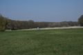
| + | Image: 2017-04-08_49_8-2.jpg|view to the hash (mind the stance behind the group of trees) | ||
| + | Image: 2017-04-08_49_8-9.png|proof | ||
| + | Image: 2017-04-08_49_8-3.jpg|view from the hash to the bike and the north | ||
| + | Image: 2017-04-08_49_8-4.jpg|some almost accidental hasher passing by | ||
| + | Image: 2017-04-08_49_8-5.jpg|stance from the hash in the west | ||
| + | Image: 2017-04-08_49_8-6.jpg|happy hasher | ||
| + | Image: 2017-04-08_49_8-7.jpg|view to the earth (hashflowers) | ||
| + | Image: 2017-04-08_49_8-8.jpg|and to a tower in the east | ||
</gallery> | </gallery> | ||
| Line 44: | Line 57: | ||
{{#vardefine:ribbonwidth|800px}} | {{#vardefine:ribbonwidth|800px}} | ||
<!-- Add any achievement ribbons you earned below, or remove this section --> | <!-- Add any achievement ribbons you earned below, or remove this section --> | ||
| + | {{land geohash | ||
| + | | latitude = 49 | ||
| + | | longitude = 8 | ||
| + | | date = 2017-04-08 | ||
| + | | name = DODO | ||
| + | }} | ||
| − | + | {{bicycle geohash | |
| − | + | | latitude = 49 | |
| − | + | | longitude = 8 | |
| + | | date = 2017-04-08 | ||
| + | | name = DODO | ||
| + | | distance = 15 KM | ||
| + | }} | ||
| − | |||
| − | |||
| − | |||
| − | |||
| − | |||
| − | |||
| − | |||
| − | |||
| − | |||
[[Category:Expeditions]] | [[Category:Expeditions]] | ||
| − | |||
| − | |||
| − | |||
| − | |||
| − | |||
| − | |||
| − | |||
[[Category:Coordinates reached]] | [[Category:Coordinates reached]] | ||
| − | |||
| − | |||
| − | |||
| − | |||
| − | |||
| − | |||
| − | |||
| − | |||
| − | |||
| − | |||
| − | |||
| − | |||
| − | |||
| − | |||
| − | |||
| − | |||
| − | |||
| − | |||
Revision as of 19:12, 9 April 2017
| Sat 8 Apr 2017 in 49,8: 49.3263985, 8.3406244 geohashing.info google osm bing/os kml crox |
Location
A meadow near Hanhofen
Participants
Plans
To close, not to go. I wanted to go there by bike in the afternoon.
Expedition
I started at home at half past 3. The weather was sunny and warm, and I had just 8 KM to ride, a perfect location for me and my bike. The only downer was that I had to drive to Koblenz this afternoon so I had not so much time and had to hurry a little. I lost my way in Hahnhofen for maybe 200 m, enough to disqualify for a tron achievemnet, but that would have been hardly possible anyway as I had to drive 50 m or so into the way to the hashmeadow. Next to the meadow was a bench. I left my bike there and walked the remaining 70 m into the meadow. No big deal. I took some pictures, and returned to the bench to wait the last 5 minutes until 4. As expected nobody else came (at least no hasher), and so I hurried back home. A great short ride before the drive thanks to geohashing.
Tracklog
Photos
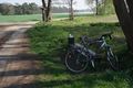
bike and bench (and proof of transport)
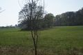
view to the hash (mind the stance behind the group of trees)
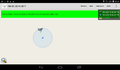
proof
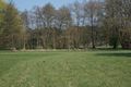
view from the hash to the bike and the north
some almost accidental hasher passing by
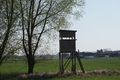
stance from the hash in the west

happy hasher
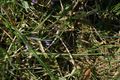
view to the earth (hashflowers)
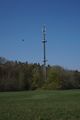
and to a tower in the east


Achievements
DODO earned the Land geohash achievement
|
DODO earned the Bicycle geohash achievement
|