Difference between revisions of "2017-04-09 49 8"
imported>DODO (Created page with "{{subst:Expedition |lat = 49 |lon = 8 |date = 2017-04-09 }}") |
imported>DODO |
||
| Line 20: | Line 20: | ||
== Location == | == Location == | ||
<!-- where you've surveyed the hash to be --> | <!-- where you've surveyed the hash to be --> | ||
| + | A moist and dense forest near the airfield of Dossenheim. | ||
== Participants == | == Participants == | ||
<!-- who attended: If you link to your wiki user name in this section, your expedition will be picked up by the various statistics generated for geohashing. You may use three tildes ~ as a shortcut to automatically insert the user signature of the account you are editing with. | <!-- who attended: If you link to your wiki user name in this section, your expedition will be picked up by the various statistics generated for geohashing. You may use three tildes ~ as a shortcut to automatically insert the user signature of the account you are editing with. | ||
--> | --> | ||
| + | [[User:DODO|DODO]] | ||
== Plans == | == Plans == | ||
<!-- what were the original plans --> | <!-- what were the original plans --> | ||
| + | Make a little detour on my way home from Koblenz, stop in Dossenheim and walk to the hash. | ||
== Expedition == | == Expedition == | ||
<!-- how it all turned out. your narrative goes here. --> | <!-- how it all turned out. your narrative goes here. --> | ||
| + | Well, I had the idea to swing by yesterday, but didn't realy believe that I would do so. But the weather was so great that I just couldn't resist. When I reached home I had driven 173 KM instead of the 155, I needed for the way there, so I just made a 18 KM detour what is within my fuel policy. I stopped the car near the purification plant of Oppenheim. From here I walked southwards along a dike, and lot of other people were out in the sun either. Soon I reached the airfield and had to walk all the 2 KM of its length. Behind the airfield was a little forest wih a hash in it. It was very dense, and I didn't find a way into the copse from this side. After a while I reached the river Rhine, and the copse seemed a little less dense from this side. But after the first row of trees and bushes I came at a wide area of reed. Still 100 m to go and that didn't look passable at all. Well, just have a last look at this falen trunk over there (is it worth to creep through the bushes?). | ||
| + | |||
| + | Well, short story long, there was a kind of path next to the trunk and on the other side of the trunk ended the reed. Thanks to the weather of the last days the path was almost dry, and I could cross the reed area. I still had to creep through a lot of bushes and climb several more falen trunks, but in the end I reached the hash and the way there was hard enough to reward me with a MNIMB. | ||
== Tracklog == | == Tracklog == | ||
<!-- if your GPS device keeps a log, you may post a link here --> | <!-- if your GPS device keeps a log, you may post a link here --> | ||
| + | [https://www.komoot.de/tour/15392764 aA 7 KM walk] | ||
== Photos == | == Photos == | ||
| Line 39: | Line 46: | ||
--> | --> | ||
<gallery perrow="5"> | <gallery perrow="5"> | ||
| + | Image: 2017-04-09_49_8-1.jpg|Where I left little car | ||
| + | Image: 2017-04-09_49_8-2.jpg|view to Dossenheim | ||
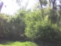
| + | Image: 2017-04-09_49_8-3.jpg|very dense bushes. No entry there | ||
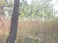
| + | Image: 2017-04-09_49_8-4.jpg|I reached the river Rhine | ||
| + | Image: 2017-04-09_49_8-5.jpg|Maybe I can enter there | ||
| + | Image: 2017-04-09_49_8-6.jpg|reed | ||
| + | Image: 2017-04-09_49_8-7.jpg|more reed | ||
| + | Image: 2017-04-09_49_8-13.png|I give up, I'm afraid | ||
| + | Image: 2017-04-09_49_8-12.jpg|Or maybe there? | ||
| + | Image: 2017-04-09_49_8-14.png|proof | ||
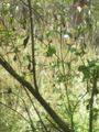
| + | Image: 2017-04-09_49_8-8.jpg|the hash to the east | ||
| + | Image: 2017-04-09_49_8-9.jpg|and the west | ||
| + | Image: 2017-04-09_49_8-10.jpg|and the hasher | ||
| + | Image: 2017-04-09_49_8-11.jpg|I found this big X near the hash. Ninja? | ||
</gallery> | </gallery> | ||
== Achievements == | == Achievements == | ||
{{#vardefine:ribbonwidth|800px}} | {{#vardefine:ribbonwidth|800px}} | ||
| − | + | {{land geohash | |
| + | | latitude = 49 | ||
| + | | longitude = 8 | ||
| + | | date = 2017-04-09 | ||
| + | | name = DODO | ||
| + | }} | ||
| − | + | {{mnimb geohash | |
| − | |||
| − | |||
| − | + | | latitude = 49 | |
| + | | longitude = 8 | ||
| + | | date = 2017-04-09 | ||
| + | | name = DODO | ||
| + | | image = image name (optional) | ||
| − | + | }} | |
| − | + | [[Category:Expeditions]] | |
| − | [[Category: | ||
| − | |||
| − | |||
| − | |||
| − | |||
| − | |||
| − | |||
| − | |||
| − | |||
| − | |||
| − | |||
| − | |||
| − | |||
[[Category:Coordinates reached]] | [[Category:Coordinates reached]] | ||
| − | |||
| − | |||
| − | |||
| − | |||
| − | |||
| − | |||
| − | |||
| − | |||
| − | |||
| − | |||
| − | |||
| − | |||
| − | |||
| − | |||
| − | |||
| − | |||
| − | |||
| − | |||
Revision as of 19:49, 9 April 2017
| Sun 9 Apr 2017 in 49,8: 49.8322100, 8.3737482 geohashing.info google osm bing/os kml crox |
Location
A moist and dense forest near the airfield of Dossenheim.
Participants
Plans
Make a little detour on my way home from Koblenz, stop in Dossenheim and walk to the hash.
Expedition
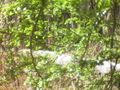
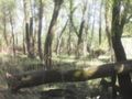
Well, I had the idea to swing by yesterday, but didn't realy believe that I would do so. But the weather was so great that I just couldn't resist. When I reached home I had driven 173 KM instead of the 155, I needed for the way there, so I just made a 18 KM detour what is within my fuel policy. I stopped the car near the purification plant of Oppenheim. From here I walked southwards along a dike, and lot of other people were out in the sun either. Soon I reached the airfield and had to walk all the 2 KM of its length. Behind the airfield was a little forest wih a hash in it. It was very dense, and I didn't find a way into the copse from this side. After a while I reached the river Rhine, and the copse seemed a little less dense from this side. But after the first row of trees and bushes I came at a wide area of reed. Still 100 m to go and that didn't look passable at all. Well, just have a last look at this falen trunk over there (is it worth to creep through the bushes?).
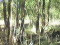
Well, short story long, there was a kind of path next to the trunk and on the other side of the trunk ended the reed. Thanks to the weather of the last days the path was almost dry, and I could cross the reed area. I still had to creep through a lot of bushes and climb several more falen trunks, but in the end I reached the hash and the way there was hard enough to reward me with a MNIMB.
Tracklog
Photos
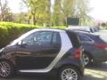
Where I left little car
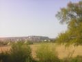
view to Dossenheim
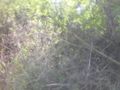
very dense bushes. No entry there
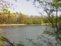
I reached the river Rhine
Maybe I can enter there
reed
more reed
I give up, I'm afraid
Or maybe there?
proof
the hash to the east
and the west
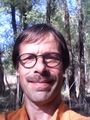
and the hasher
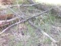
I found this big X near the hash. Ninja?


Achievements
DODO earned the Land geohash achievement
|