Difference between revisions of "2017-04-16 59 18"
From Geohashing
imported>Per S ([live] Going) |
imported>Per S |
||
| Line 1: | Line 1: | ||
| + | {| width="100%" border=0 cellpadding=0 cellspacing=0 style="border: 0; border-collapse: collapse; border-spacing: 0; margin: 0; padding: 0" | ||
| − | + | | align="left" valign="top" style="padding: 0.5em 1em 0.5em 0" | [[Image:2017-04-16_59_18_02 The Geohashers.jpg|467px]] | |
| − | + | | align="right" valign="top" | {{meetup graticule | |
| − | |||
| − | |||
| − | |||
| − | |||
| − | |||
| − | |||
| − | {{meetup graticule | ||
| lat=59 | | lat=59 | ||
| lon=18 | | lon=18 | ||
| date=2017-04-16 | | date=2017-04-16 | ||
| + | | graticule_name=Uppsala | ||
| + | | graticule_link=Uppsala, Sweden | ||
}} | }} | ||
| − | + | |} | |
| + | |||
__NOTOC__ | __NOTOC__ | ||
== Location == | == Location == | ||
| − | + | In a park in Solberga. | |
== Participants == | == Participants == | ||
| − | + | * [[User:Per S|Per S]] | |
| − | + | * iA | |
== Plans == | == Plans == | ||
| − | + | Go there by subway and bus. | |
== Expedition == | == Expedition == | ||
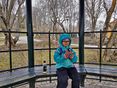
| − | + | We took the bus, ran some errands, and after a bit of a detour with the subway, we took another bus the last stretch. We arrived around 1 PM, found a suitable hash tree and then had a snack in a nearby gazebo. We took a different bus and subway on the way home, and got home around 3:30. | |
| − | |||
| − | |||
| − | |||
| − | |||
| − | |||
== Photos == | == Photos == | ||
| − | < | + | <gallery widths=117px perrow="5"> |
| − | Image: | + | Image:2017-04-16_59_18_01 Coordinates Reached.jpg | Coordinates Reached |
| − | -- | + | Image:2017-04-16_59_18_02 The Geohashers.jpg | The Geohashers |
| − | + | Image:2017-04-16_59_18_03 Geohasher.jpg | Geohasher | |
| + | Image:2017-04-16_59_18_04 Gazebo.jpg | Gazebo | ||
| + | Image:2017-04-16_59_18_05 Picnic.jpg | Picnic | ||
</gallery> | </gallery> | ||
== Achievements == | == Achievements == | ||
| − | {{#vardefine:ribbonwidth| | + | {{#vardefine:ribbonwidth|100%}} |
| − | + | ||
| + | {| | ||
| − | + | |{{Public transport geohash | |
| − | + | | latitude = 59 | |
| − | + | | longitude = 18 | |
| + | | date = 2017-04-16 | ||
| + | | name = Per S | ||
| + | | image = 2012-05-04 59 18 12-58-20-663.jpg | ||
| + | }} | ||
| − | + | |- | |
| − | + | |{{Picnic_geohash | |
| − | + | | latitude = 59 | |
| − | + | | longitude = 18 | |
| − | + | | date = 2017-04-16 | |
| + | | name = iA | ||
| + | | image = 2017-04-16_59_18_05 Picnic.jpg | ||
| + | | food = sandwich | ||
| + | }} | ||
| − | + | |- | |
| + | |||
| + | |{{drag-along | ||
| + | | latitude = 59 | ||
| + | | longitude = 18 | ||
| + | | date = 2017-04-16 | ||
| + | | partner = iA | ||
| + | | name = [[User:Per S|Per S]] | ||
| + | | image = 2017-04-16_59_18_02 The Geohashers.jpg | ||
| + | }} | ||
| + | |||
| + | |} | ||
| − | |||
[[Category:Expeditions]] | [[Category:Expeditions]] | ||
| − | |||
[[Category:Expeditions with photos]] | [[Category:Expeditions with photos]] | ||
| − | |||
| − | |||
| − | |||
| − | |||
| − | |||
[[Category:Coordinates reached]] | [[Category:Coordinates reached]] | ||
| − | |||
| − | |||
| − | |||
| − | |||
| − | |||
| − | |||
| − | |||
| − | |||
| − | |||
| − | |||
| − | |||
| − | |||
| − | |||
| − | |||
| − | |||
| − | |||
| − | |||
| − | |||
Revision as of 21:24, 4 April 2018

|
| ||||||
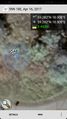
Location
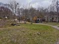
In a park in Solberga.
Participants
- Per S
- iA
Plans
Go there by subway and bus.
Expedition
We took the bus, ran some errands, and after a bit of a detour with the subway, we took another bus the last stretch. We arrived around 1 PM, found a suitable hash tree and then had a snack in a nearby gazebo. We took a different bus and subway on the way home, and got home around 3:30.
Photos
Coordinates Reached
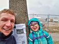
The Geohashers
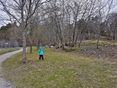
Geohasher
Gazebo
Picnic


Achievements
| |||
| |||
|