Difference between revisions of "2017-04-29 47 11"
imported>Claralucia9 (→Participants) |
imported>Fippe (coordinates reached) |
||
| Line 48: | Line 48: | ||
<!-- Add any achievement ribbons you earned below, or remove this section --> | <!-- Add any achievement ribbons you earned below, or remove this section --> | ||
| − | |||
| − | |||
| − | |||
| − | |||
| − | |||
| − | |||
| − | |||
| − | |||
| − | |||
| − | |||
| − | |||
| − | |||
| − | |||
| − | |||
[[Category:Expeditions]] | [[Category:Expeditions]] | ||
| − | |||
[[Category:Expeditions with photos]] | [[Category:Expeditions with photos]] | ||
| − | |||
| − | |||
| − | |||
| − | |||
| − | |||
[[Category:Coordinates reached]] | [[Category:Coordinates reached]] | ||
| − | |||
| − | |||
| − | |||
| − | |||
| − | |||
| − | |||
| − | |||
| − | |||
| − | |||
| − | |||
| − | |||
| − | |||
| − | |||
| − | |||
| − | |||
| − | |||
| − | |||
| − | |||
Revision as of 10:54, 25 July 2019
| Sat 29 Apr 2017 in 47,11: 47.8447441, 11.6541750 geohashing.info google osm bing/os kml crox |
Location
Close to the roadside just outside of Kleinhatpenning, south of Munich
Participants
Plans
Expedition
Another geohash that's not too far from home - just right for an early Saturday morning excursion I thought. On my way there by car I had to realize that the motorway exit of Holzkirchen was closed due to construction so I had to take the next exit and return. Anyway - I stopped to pick up a TB at a geocache and then headed for the hash. I had to follow a very narrow road and was lucky not to encounter any traffic in the opposite direction. Beautiful views of the rising sun over a foggy snowfield. As if the hash hat been chosen by purpose :-) I got within less then a meter from the given coordinated, marked it with a "X" in the snow, took my pictures (7:53 am) and then headed back for a family breakfast.
Tracklog
Photos
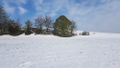
hash location
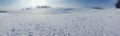
panorama from the hash
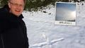
me at the cache
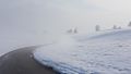
road to the hash
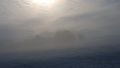
sunrise over fog
Logproof


