Difference between revisions of "2017-04-21 53 8"
imported>Kerko (Created page with " {{meetup graticule | lat=53 | lon=8 | date=2017-04-21 }} __NOTOC__ == Location == A lake surrounded by fences and walls near Oldenburg. == Participants == *User:Kerko|K...") |
(No difference)
|
Revision as of 16:41, 29 April 2017
| Fri 21 Apr 2017 in 53,8: 53.1109846, 8.1160403 geohashing.info google osm bing/os kml crox |
Location
A lake surrounded by fences and walls near Oldenburg.
Participants
Plans
I didn’t want to reach this geohash, because there’s too much water. The lake seems to be named “Roter Steinweg See”. To make it more interesting, a STUPIDMAP light (not to scale) led me there.
Expedition
I reached this lake (i. e. the walls arround it) by bike. Along the way I found some other puddles, and on the way back home I made pictures of them instead of the geohash.
As I mentioned, the lake is surrounded by fences and walls, and in addition by ramparts, buildings and other stuff. It was difficult to spot the lake behind them. When I was driving arround the lake, I made a photo of an especially representative wall as proof of location. Later, still behind fences with barbed wire, I thought I could make a photo right across the lake to catch the geohash. Bing maps confirmed it: geohash straight forward! (Second picture)
Photos
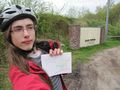
The most representative wall arround the geohash.
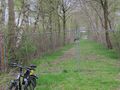
The best sight on the geohash. Geohash is in front of the building.
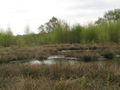
A puddle round about 600m east-northeast of the geohash. Not the lake with the geohash, but at least some water.
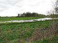
Another occurrence of water, picture taken another 100m north.


