Difference between revisions of "2017-05-25 49 8"
From Geohashing
imported>DODO (Created page with "{{subst:Expedition |lat = 49 |lon = 8 |date = 2017-05-25 }}") |
imported>DODO |
||
| Line 20: | Line 20: | ||
== Location == | == Location == | ||
<!-- where you've surveyed the hash to be --> | <!-- where you've surveyed the hash to be --> | ||
| + | In the forest between Ketsch and Schwetzingen. | ||
== Participants == | == Participants == | ||
<!-- who attended: If you link to your wiki user name in this section, your expedition will be picked up by the various statistics generated for geohashing. You may use three tildes ~ as a shortcut to automatically insert the user signature of the account you are editing with. | <!-- who attended: If you link to your wiki user name in this section, your expedition will be picked up by the various statistics generated for geohashing. You may use three tildes ~ as a shortcut to automatically insert the user signature of the account you are editing with. | ||
--> | --> | ||
| − | + | [[User:DODO|DODO]] | |
== Plans == | == Plans == | ||
<!-- what were the original plans --> | <!-- what were the original plans --> | ||
| − | + | The hash was convenietly close to home but we had other plans. Nevertheless, the plans didn't realise and so I had some time in the afternoon. Just saddle my bike and hava a short ride. | |
== Expedition == | == Expedition == | ||
<!-- how it all turned out. your narrative goes here. --> | <!-- how it all turned out. your narrative goes here. --> | ||
| + | Well, I just saddled my bike at 16:15 and started. As it was a public holyday in Germany there were plenty of bikes on the way. I reached the hash fter 45 minutes and a short struggle through the forest on a clearing. I took the usual pictures and continued my way. I reached home after 1 and a half hour. | ||
== Tracklog == | == Tracklog == | ||
<!-- if your GPS device keeps a log, you may post a link here --> | <!-- if your GPS device keeps a log, you may post a link here --> | ||
| + | [https://www.komoot.de/tour/17065638 31 KM by bike] | ||
== Photos == | == Photos == | ||
| Line 38: | Line 41: | ||
Image:2012-##-## ## ## Alpha.jpg | Witty Comment | Image:2012-##-## ## ## Alpha.jpg | Witty Comment | ||
--> | --> | ||
| − | <gallery perrow=" | + | <gallery perrow="4"> |
| + | Image:2017-05-25_49_8-1.jpg|bike and proof of transport | ||
| + | Image:2017-05-25_49_8-7.png|proof | ||
| + | Image:2017-05-25_49_8-2.jpg|view to the west | ||
| + | Image:2017-05-25_49_8-3.jpg|north | ||
| + | Image:2017-05-25_49_8-4.jpg|east | ||
| + | Image:2017-05-25_49_8-5.jpg|and south (luckily the hash wasn't in the thicket | ||
| + | Image:2017-05-25_49_8-6.jpg|a happy hasher | ||
</gallery> | </gallery> | ||
| Line 45: | Line 55: | ||
<!-- Add any achievement ribbons you earned below, or remove this section --> | <!-- Add any achievement ribbons you earned below, or remove this section --> | ||
| − | + | {{land geohash | |
| − | + | | latitude = 49 | |
| − | + | | longitude = 8 | |
| + | | date = 2017-05-25 | ||
| + | | name = DODO | ||
| + | }} | ||
| − | + | {{bicycle geohash | |
| + | | latitude = 49 | ||
| + | | longitude = 8 | ||
| + | | date = 2017-05-25 | ||
| + | | name = DODO | ||
| + | | distance = 31 KM | ||
| + | }} | ||
| − | |||
| − | |||
| − | |||
| − | |||
| − | |||
| − | |||
| − | |||
[[Category:Expeditions]] | [[Category:Expeditions]] | ||
| − | |||
| − | |||
| − | |||
| − | |||
| − | |||
| − | |||
| − | |||
[[Category:Coordinates reached]] | [[Category:Coordinates reached]] | ||
| − | |||
| − | |||
| − | |||
| − | |||
| − | |||
| − | |||
| − | |||
| − | |||
| − | |||
| − | |||
| − | |||
| − | |||
| − | |||
| − | |||
| − | |||
| − | |||
| − | |||
| − | |||
Revision as of 16:18, 25 May 2017
| Thu 25 May 2017 in 49,8: 49.3652464, 8.5599124 geohashing.info google osm bing/os kml crox |
Location
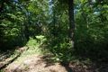
In the forest between Ketsch and Schwetzingen.
Participants
Plans
The hash was convenietly close to home but we had other plans. Nevertheless, the plans didn't realise and so I had some time in the afternoon. Just saddle my bike and hava a short ride.
Expedition
Well, I just saddled my bike at 16:15 and started. As it was a public holyday in Germany there were plenty of bikes on the way. I reached the hash fter 45 minutes and a short struggle through the forest on a clearing. I took the usual pictures and continued my way. I reached home after 1 and a half hour.
Tracklog
Photos
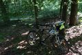
bike and proof of transport
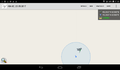
proof
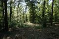
view to the west
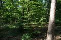
north
east
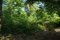
and south (luckily the hash wasn't in the thicket

a happy hasher


Achievements
DODO earned the Land geohash achievement
|
DODO earned the Bicycle geohash achievement
|