Difference between revisions of "2017-05-26 49 8"
imported>DODO (→Plans) |
imported>DODO |
||
| Line 33: | Line 33: | ||
== Expedition == | == Expedition == | ||
<!-- how it all turned out. your narrative goes here. --> | <!-- how it all turned out. your narrative goes here. --> | ||
| − | + | The tour started the same way like thetour [[2017-05-21_48_7|last week]]. After 28 kilometers I reached another ferry. It took me almost half an hour to cross the river. Then I soon reached the south of Karlsruhe. I was pretty sure to be at the hash, but my gps located me on the other side of the houses in the gardens. So I had to walk for a while. A neighbour was intensly looking at me, and just when gps decided, that I was on the right side of the houses he asked "Klappts?" ("Does it work"). I guess, he thought I was a pokemon-hunter. On my way back my batteries died and so I had to guess the path for the last 30 kilometers. Well, I made some wrong decisions, but I didn't so to bad. I came alog an ice cream parlor and had an ice-cream and a beer. After I'Ve continued my ride, I took another wrong turn and came to the ferry to Speyer. Not to bad, I decided to take the ferry and not the bridge. I came home at 3 pm. | |
== Tracklog == | == Tracklog == | ||
<!-- if your GPS device keeps a log, you may post a link here --> | <!-- if your GPS device keeps a log, you may post a link here --> | ||
| Line 42: | Line 42: | ||
--> | --> | ||
<gallery perrow="5"> | <gallery perrow="5"> | ||
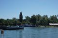
| + | Image:2017-05-26_49_8-1.jpg|a ferry again | ||
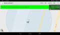
| + | Image:2017-05-26_49_8-9.png|proof | ||
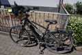
| + | Image:2017-05-26_49_8-2.jpg|my bull at the hash | ||
| + | Image:2017-05-26_49_8-3.jpg|and a hasher | ||
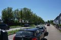
| + | Image:2017-05-26_49_8-4.jpg|along the road to the south | ||
| + | Image:2017-05-26_49_8-5.jpg|and to the north | ||
| + | Image:2017-05-26_49_8-6.jpg|not at the hash but on my way back | ||
| + | Image:2017-05-26_49_8-7.jpg|another nice view on my way home | ||
| + | Image:2017-05-26_49_8-8.jpg|and another ferry | ||
</gallery> | </gallery> | ||
| Line 54: | Line 63: | ||
<!-- ==REQUEST FOR TWITTER BOT== Please leave either the New report or the Expedition planning category in as long as you work on it. This helps the twitter bot a lot with announcing the right outcome at the right moment. --> | <!-- ==REQUEST FOR TWITTER BOT== Please leave either the New report or the Expedition planning category in as long as you work on it. This helps the twitter bot a lot with announcing the right outcome at the right moment. --> | ||
| − | + | {{land geohash | |
| − | + | | latitude = 49 | |
| − | + | | longitude = 8 | |
| − | + | | date = 2017-05-25 | |
| + | | name = DODO | ||
| + | }} | ||
| + | |||
| + | {{consecutive geohash | ||
| + | | count = 2 | ||
| + | | latitude = 49 | ||
| + | | longitude = 8 | ||
| + | | date = 2017-05-25 | ||
| + | | name = DODO | ||
| + | }} | ||
| − | |||
| − | |||
[[Category:Expeditions]] | [[Category:Expeditions]] | ||
| − | + | ||
| − | |||
| − | |||
| − | |||
| − | |||
| − | |||
| − | |||
[[Category:Coordinates reached]] | [[Category:Coordinates reached]] | ||
| − | |||
| − | |||
| − | |||
| − | |||
| − | |||
| − | |||
| − | |||
| − | |||
| − | |||
| − | |||
| − | |||
| − | |||
| − | |||
| − | |||
| − | |||
| − | |||
| − | |||
| − | |||
Revision as of 18:06, 26 May 2017
| Fri 26 May 2017 in 49,8: 49.0232997, 8.3563891 geohashing.info google osm bing/os kml crox |
Location
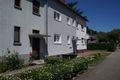
On the Neureuter Straße in Karlsruhe-Nordweststadt.
Participants
Plans
Go there by bull. Start in 10 minutes (10:15). ETA: between 12:00 and 12:30.
Expedition
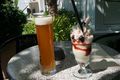
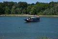
The tour started the same way like thetour last week. After 28 kilometers I reached another ferry. It took me almost half an hour to cross the river. Then I soon reached the south of Karlsruhe. I was pretty sure to be at the hash, but my gps located me on the other side of the houses in the gardens. So I had to walk for a while. A neighbour was intensly looking at me, and just when gps decided, that I was on the right side of the houses he asked "Klappts?" ("Does it work"). I guess, he thought I was a pokemon-hunter. On my way back my batteries died and so I had to guess the path for the last 30 kilometers. Well, I made some wrong decisions, but I didn't so to bad. I came alog an ice cream parlor and had an ice-cream and a beer. After I'Ve continued my ride, I took another wrong turn and came to the ferry to Speyer. Not to bad, I decided to take the ferry and not the bridge. I came home at 3 pm.
Tracklog
Photos
a ferry again
proof
my bull at the hash

and a hasher
along the road to the south
and to the north

not at the hash but on my way back
another nice view on my way home
and another ferry


Achievements
DODO earned the Land geohash achievement
|
DODO earned the Consecutive geohash achievement
|