Difference between revisions of "2017-05-26 49 8"
imported>DODO (Created page with "{{subst:Expedition |lat = 49 |lon = 8 |date = 2017-05-26 }}") |
imported>FippeBot m (Location) |
||
| (5 intermediate revisions by 2 users not shown) | |||
| Line 20: | Line 20: | ||
== Location == | == Location == | ||
<!-- where you've surveyed the hash to be --> | <!-- where you've surveyed the hash to be --> | ||
| + | On the Neureuter Straße in Karlsruhe-Nordweststadt. | ||
== Participants == | == Participants == | ||
<!-- who attended: If you link to your wiki user name in this section, your expedition will be picked up by the various statistics generated for geohashing. You may use three tildes ~ as a shortcut to automatically insert the user signature of the account you are editing with. | <!-- who attended: If you link to your wiki user name in this section, your expedition will be picked up by the various statistics generated for geohashing. You may use three tildes ~ as a shortcut to automatically insert the user signature of the account you are editing with. | ||
--> | --> | ||
| + | [[User:DODO|DODO]] | ||
== Plans == | == Plans == | ||
<!-- what were the original plans --> | <!-- what were the original plans --> | ||
| + | Go there by bull. Start in 10 minutes (10:15). ETA: between 12:00 and 12:30. | ||
== Expedition == | == Expedition == | ||
<!-- how it all turned out. your narrative goes here. --> | <!-- how it all turned out. your narrative goes here. --> | ||
| − | + | The tour started the same way like thetour [[2017-05-21_48_7|last week]]. After 28 kilometers I reached another ferry. It took me almost half an hour to cross the river. Then I soon reached the south of Karlsruhe. I was pretty sure to be at the hash, but my gps located me on the other side of the houses in the gardens. So I had to walk for a while. A neighbour was intensly looking at me, and just when gps decided, that I was on the right side of the houses he asked "Klappts?" ("Does it work"). I guess, he thought I was a pokemon-hunter. On my way back my batteries died and so I had to guess the path for the last 30 kilometers. Well, I made some wrong decisions, but I didn't so to bad. I came alog an ice cream parlor and had an ice-cream and a beer. After I'Ve continued my ride, I took another wrong turn and came to the ferry to Speyer. Not to bad, I decided to take the ferry and not the bridge. I came home at 3 pm. | |
== Tracklog == | == Tracklog == | ||
<!-- if your GPS device keeps a log, you may post a link here --> | <!-- if your GPS device keeps a log, you may post a link here --> | ||
| Line 39: | Line 42: | ||
--> | --> | ||
<gallery perrow="5"> | <gallery perrow="5"> | ||
| + | Image:2017-05-26_49_8-1.jpg|a ferry again | ||
| + | Image:2017-05-26_49_8-9.png|proof | ||
| + | Image:2017-05-26_49_8-2.jpg|my bull at the hash | ||
| + | Image:2017-05-26_49_8-3.jpg|and a hasher | ||
| + | Image:2017-05-26_49_8-4.jpg|along the road to the south | ||
| + | Image:2017-05-26_49_8-5.jpg|and to the north | ||
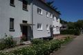
| + | Image:2017-05-26_49_8-6.jpg|not at the hash but on my way back | ||
| + | Image:2017-05-26_49_8-7.jpg|another nice view on my way home | ||
| + | Image:2017-05-26_49_8-8.jpg|and another ferry | ||
</gallery> | </gallery> | ||
| Line 45: | Line 57: | ||
<!-- Add any achievement ribbons you earned below, or remove this section --> | <!-- Add any achievement ribbons you earned below, or remove this section --> | ||
| − | + | {{land geohash | |
| − | + | | latitude = 49 | |
| − | + | | longitude = 8 | |
| + | | date = 2017-05-25 | ||
| + | | name = DODO | ||
| + | }} | ||
| − | + | {{consecutive geohash | |
| + | | count = 2 | ||
| + | | latitude = 49 | ||
| + | | longitude = 8 | ||
| + | | date = 2017-05-25 | ||
| + | | name = DODO | ||
| + | }} | ||
| − | |||
| − | |||
| − | |||
| − | |||
| − | + | [[Category:Expeditions]] | |
| − | |||
| − | |||
| − | |||
| − | |||
| − | |||
| − | |||
| − | |||
| − | |||
| − | |||
[[Category:Coordinates reached]] | [[Category:Coordinates reached]] | ||
| − | + | {{location|DE|BW|KA|city=true}} | |
| − | |||
| − | |||
| − | |||
| − | |||
| − | |||
| − | |||
| − | |||
| − | |||
| − | |||
| − | |||
| − | |||
| − | |||
| − | |||
| − | |||
| − | |||
| − | |||
| − | |||
Latest revision as of 18:29, 26 July 2019
| Fri 26 May 2017 in 49,8: 49.0232997, 8.3563891 geohashing.info google osm bing/os kml crox |
Location
On the Neureuter Straße in Karlsruhe-Nordweststadt.
Participants
Plans
Go there by bull. Start in 10 minutes (10:15). ETA: between 12:00 and 12:30.
Expedition
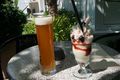
The tour started the same way like thetour last week. After 28 kilometers I reached another ferry. It took me almost half an hour to cross the river. Then I soon reached the south of Karlsruhe. I was pretty sure to be at the hash, but my gps located me on the other side of the houses in the gardens. So I had to walk for a while. A neighbour was intensly looking at me, and just when gps decided, that I was on the right side of the houses he asked "Klappts?" ("Does it work"). I guess, he thought I was a pokemon-hunter. On my way back my batteries died and so I had to guess the path for the last 30 kilometers. Well, I made some wrong decisions, but I didn't so to bad. I came alog an ice cream parlor and had an ice-cream and a beer. After I'Ve continued my ride, I took another wrong turn and came to the ferry to Speyer. Not to bad, I decided to take the ferry and not the bridge. I came home at 3 pm.
Tracklog
Photos
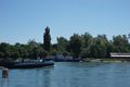
a ferry again
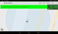
proof

my bull at the hash

and a hasher
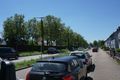
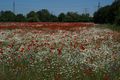
along the road to the south
and to the north
not at the hash but on my way back
another nice view on my way home
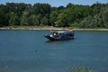
and another ferry


Achievements
DODO earned the Land geohash achievement
|
DODO earned the Consecutive geohash achievement
|