Difference between revisions of "1981-07-22 48 11"
imported>Solli (Created page with "{{subst:Expedition |lat = 48 |lon = 11 |date = 1981-07-22 }}") |
imported>FippeBot m (Location) |
||
| (3 intermediate revisions by 2 users not shown) | |||
| Line 1: | Line 1: | ||
| − | |||
| − | |||
| − | |||
| − | |||
| − | |||
| − | |||
| − | |||
| − | |||
| − | |||
| − | |||
{{meetup graticule | {{meetup graticule | ||
| lat=48 | | lat=48 | ||
| lon=11 | | lon=11 | ||
| date=1981-07-22 | | date=1981-07-22 | ||
| + | | retro = 1 | ||
}} | }} | ||
| − | |||
__NOTOC__ | __NOTOC__ | ||
| + | |||
| + | Solli's origin geohash, visited on 2017-05-27. | ||
== Location == | == Location == | ||
| − | + | On a field near Pettenhofen, between Neustadt an der Donau and Ingolstadt | |
== Participants == | == Participants == | ||
| − | + | * [[User:Solli|Solli]] | |
| − | |||
== Plans == | == Plans == | ||
| − | + | A spontaneous idea to visit my origin geohash, since I happened to be nearby. | |
== Expedition == | == Expedition == | ||
| − | + | I looked up my origin geohash location some months ago and decided to go there someday. But since it's about 100km from my home location I did not spend much thought on that. On May 27th I happened to drive through Neustadt and remembered that the hashpoint is not far away. So I looked it up, drove to Pettenhoven and went for a walk. | |
| − | + | The area is actually quite nice and I had a lovely walk along a little stream (which I had to cross twice, but no big deal). I found out that the location was probably in a wheat field, so I walked between potatoes and wheat to the closest possible spot. I came within 10 metres of the location. It would have been possible to step into the field carefully without harming the crops, but I did not want to risk trampling anything down. Since it was not more than 10m (more likely only 5m according to the areal image) and my app already told me that I was there, I called it a success. If somebody wants to be really pedantic about it I guess I have to come back in the winter, but IMHO I did reach the coordinates. | |
| − | |||
== Photos == | == Photos == | ||
| − | |||
| − | |||
| − | |||
<gallery perrow="5"> | <gallery perrow="5"> | ||
| + | Image:1981-07-22 48 11 Solli 01.jpg | Nice little stream | ||
| + | Image:1981-07-22 48 11 Solli 02.jpg | What kind of bush is that? Not elder anyway. | ||
| + | Image:1981-07-22 48 11 Solli 03.jpg | Closeup of not-elder-bush | ||
| + | Image:1981-07-22 48 11 Solli 04.jpg | View from the hashpoint | ||
| + | Image:1981-07-22 48 11 Solli 05.jpg | The hashpoint (more or less) | ||
| + | Image:1981-07-22 48 11 Solli 06.jpg | Very Stupid Grin (tm) | ||
| + | Image:1981-07-22 48 11 Solli 07.png | Proof or not proof, that is the question | ||
| + | Image:1981-07-22 48 11 Solli 08.png | Proof 2 | ||
</gallery> | </gallery> | ||
== Achievements == | == Achievements == | ||
{{#vardefine:ribbonwidth|800px}} | {{#vardefine:ribbonwidth|800px}} | ||
| − | + | {{origin geohash | |
| + | | latitude = 48 | ||
| + | | longitude = 11 | ||
| + | | date = 1981-07-22 | ||
| + | | on = 2017-05-27 | ||
| + | | name = Solli | ||
| + | }} | ||
| − | |||
| − | |||
| − | |||
| − | |||
| − | |||
| − | |||
| − | |||
| − | |||
| − | |||
| − | |||
| − | |||
| − | |||
| − | |||
| − | |||
| − | |||
| − | |||
[[Category:Expeditions with photos]] | [[Category:Expeditions with photos]] | ||
| − | [[Category: | + | [[Category:Retro coordinates reached]] |
| − | + | {{location|DE|BY|IN}} | |
| − | |||
| − | |||
| − | |||
| − | |||
| − | |||
| − | |||
| − | |||
| − | |||
| − | |||
| − | |||
| − | |||
| − | |||
| − | |||
| − | |||
| − | |||
| − | |||
| − | |||
| − | |||
| − | |||
| − | |||
| − | |||
| − | |||
Latest revision as of 03:50, 7 August 2019
| Wed 22 Jul 1981 in 48,11: 48.7820216, 11.2941291 geohashing.info google osm bing/os kml crox |
Solli's origin geohash, visited on 2017-05-27.
Location
On a field near Pettenhofen, between Neustadt an der Donau and Ingolstadt
Participants
Plans
A spontaneous idea to visit my origin geohash, since I happened to be nearby.
Expedition
I looked up my origin geohash location some months ago and decided to go there someday. But since it's about 100km from my home location I did not spend much thought on that. On May 27th I happened to drive through Neustadt and remembered that the hashpoint is not far away. So I looked it up, drove to Pettenhoven and went for a walk.
The area is actually quite nice and I had a lovely walk along a little stream (which I had to cross twice, but no big deal). I found out that the location was probably in a wheat field, so I walked between potatoes and wheat to the closest possible spot. I came within 10 metres of the location. It would have been possible to step into the field carefully without harming the crops, but I did not want to risk trampling anything down. Since it was not more than 10m (more likely only 5m according to the areal image) and my app already told me that I was there, I called it a success. If somebody wants to be really pedantic about it I guess I have to come back in the winter, but IMHO I did reach the coordinates.
Photos
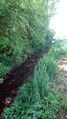
Nice little stream
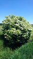
What kind of bush is that? Not elder anyway.
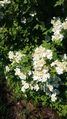
Closeup of not-elder-bush
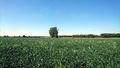
View from the hashpoint
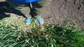
The hashpoint (more or less)

Very Stupid Grin (tm)
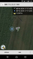
Proof or not proof, that is the question

Proof 2


Achievements
Solli earned the Origin geohash achievement
|