Difference between revisions of "2017-07-08 60 24"
imported>PPP (→Photos) |
imported>FippeBot m (Location) |
||
| (3 intermediate revisions by one other user not shown) | |||
| Line 24: | Line 24: | ||
<!-- who attended: If you link to your wiki user name in this section, your expedition will be picked up by the various statistics generated for geohashing. You may use three tildes ~ as a shortcut to automatically insert the user signature of the account you are editing with. | <!-- who attended: If you link to your wiki user name in this section, your expedition will be picked up by the various statistics generated for geohashing. You may use three tildes ~ as a shortcut to automatically insert the user signature of the account you are editing with. | ||
--> | --> | ||
| − | [[User:PPP|PPP]] ([[User talk:PPP|talk]])8 July 2017 (UTC) | + | [[User:PPP|PPP]] ([[User talk:PPP|talk]]) Around 18 @ 8 July 2017 (UTC) |
== Plans == | == Plans == | ||
<!-- what were the original plans --> | <!-- what were the original plans --> | ||
| − | [[User:PPP|PPP]] ([[User talk:PPP|talk]]) | + | [[User:PPP|PPP]] ([[User talk:PPP|talk]]) Noticed that Saturdays 60 24 will be reachable by bike and the weather according to forecast will be suitable for cycling. |
Leaving Helsinki around 17:00 and arriving maybe an hour later, estimated distance is 20-25 km | Leaving Helsinki around 17:00 and arriving maybe an hour later, estimated distance is 20-25 km | ||
| Line 38: | Line 38: | ||
For the final approach I used Geohash Droid and got green well before ~10m of the actual location. Had to do few extra circles to get that close to actual location. | For the final approach I used Geohash Droid and got green well before ~10m of the actual location. Had to do few extra circles to get that close to actual location. | ||
| − | == Tracklog == | + | |
| − | + | <!-- == Tracklog == | |
| + | if your GPS device keeps a log, you may post a link here --> | ||
== Photos == | == Photos == | ||
| Line 68: | Line 69: | ||
[[Category:Expeditions with photos]] | [[Category:Expeditions with photos]] | ||
[[Category:Coordinates reached]] | [[Category:Coordinates reached]] | ||
| + | {{location|FI|18}} | ||
Latest revision as of 02:43, 16 August 2019
| Sat 8 Jul 2017 in 60,24: 60.3493611, 24.9721675 geohashing.info google osm bing/os kml crox |
Location
Tuusula / Vantaa near the end of Helsinki-Vantaa airpot Runaway L22 / L04 in the bushes of the Kratinkallio
Participants
PPP (talk) Around 18 @ 8 July 2017 (UTC)
Plans
PPP (talk) Noticed that Saturdays 60 24 will be reachable by bike and the weather according to forecast will be suitable for cycling. Leaving Helsinki around 17:00 and arriving maybe an hour later, estimated distance is 20-25 km
Expedition
Straight forward ride. Lost the planned track only once.
For the final approach I used Geohash Droid and got green well before ~10m of the actual location. Had to do few extra circles to get that close to actual location.
Photos
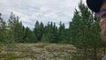
The location - Somewhere there is the north end of the Helsinki-Vantaa Airport runways 22 / 04
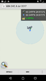
Done this - Once again I send this directly from the location, but it never arrived - too strange? This time it hanged while uploading
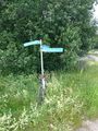
Quite far from everywhere, in the side of the private road and still almost in the backyard
Filling up after the logging and before heading to next 40 Km
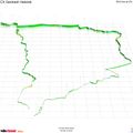
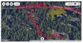
The whole track in veloviewer


Achievements
PPP earned the Bicycle geohash achievement
|