Difference between revisions of "2017-07-28 42 -85"
From Geohashing
imported>Mcbaneg (Created page with "<!-- If you did not specify these parameters in the template, please substitute appropriate values for IMAGE, LAT, LON, and DATE (YYYY-MM-DD format) {{{image|dummy.jpg}}}|...") |
imported>FippeBot m (Location) |
||
| Line 52: | Line 52: | ||
[[Category:Expeditions with photos]] | [[Category:Expeditions with photos]] | ||
[[Category:Coordinates reached]] | [[Category:Coordinates reached]] | ||
| + | {{location|US|MI|KN}} | ||
Latest revision as of 02:47, 16 August 2019
| Fri 28 Jul 2017 in 42,-85: 42.8074387, -85.6278668 geohashing.info google osm bing/os kml crox |
Location
Prairie Wolf Park, Gaines, MI
Participants
Expedition
This one looked easy, in a meadow in a nearby park. I went down after dinner with colleagues, and got there just at dusk. The park incorporates parts of a former farm. There was one interesting clamber down a stone wall to get from the park trail to the meadow but otherwise the expedition was straightforward.
I got some interesting sky photos but my attempts at Stupid Grin photos in the twilight were failures.
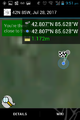
Proof.
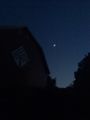
Barn and sky, shortly after arrival at entrance.
View along path toward hashpoint.
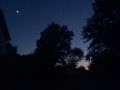
View southwest from hashpoint.
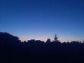
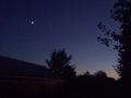
View west (duh) from hashpoint.


