Difference between revisions of "2017-08-27 51 10"
imported>GeorgDerReisende (new report) |
imported>FippeBot m (Location) |
||
| (One intermediate revision by one other user not shown) | |||
| Line 1: | Line 1: | ||
| − | |||
| − | |||
| − | |||
| − | |||
| − | |||
| − | |||
| − | |||
| − | |||
| − | |||
| − | |||
{{meetup graticule | {{meetup graticule | ||
| lat=51 | | lat=51 | ||
| Line 19: | Line 9: | ||
== Location == | == Location == | ||
| − | + | ||
| + | The hash lay on the western slope of the Wieter hill at Northeim. | ||
== Participants == | == Participants == | ||
| − | + | ||
| − | + | [[User:GeorgDerReisende|GeorgDerReisende]] | |
== Plans == | == Plans == | ||
| − | + | ||
| + | Hitchhiking and walking. | ||
== Expedition == | == Expedition == | ||
| − | |||
| − | + | I left home at 11 o'clock and started to hitchhike at 12. With four cars I arrived at Northeim. I walked through the city and climbed onto the Wieter hill. There was a steep way to climb with 55 meters height on 200 meters distance. I only followed the road and first I saw an interesting look to the hill and then my GPS told me, there it is. I got a 3 meter distance and decided, at that stump, there is the hash. But I saw the footway behind and as I am an experienced geohasher in German woods, I wanted to get the zero meter mark. I walked back to the junction and took the footway uphill. And the GPS told me, that the hash was on the way, with the tree stump five meters away. | |
| − | + | ||
| + | Afterhash I climbed onto the top of the hill and mounted the tower and had some views around. | ||
== Photos == | == Photos == | ||
| Line 39: | Line 31: | ||
--> | --> | ||
<gallery perrow="5"> | <gallery perrow="5"> | ||
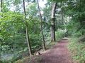
| + | Image:2017-08-27 51 10 GeorgDerReisende 0666.jpg | a steep footway | ||
| + | Image:2017-08-27 51 10 GeorgDerReisende 0669.jpg | look into the hill | ||
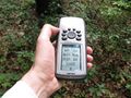
| + | Image:2017-08-27 51 10 GeorgDerReisende 0670.jpg | three meters to hash | ||
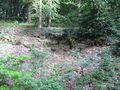
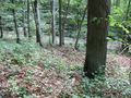
| + | Image:2017-08-27 51 10 GeorgDerReisende 0673.jpg | there, at the stump | ||
| + | Image:2017-08-27 51 10 GeorgDerReisende 0674.jpg | the junction | ||
| + | Image:2017-08-27 51 10 GeorgDerReisende 0677.jpg | arrived! | ||
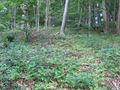
| + | Image:2017-08-27 51 10 GeorgDerReisende 0678.jpg | the stump is five meters away | ||
| + | Image:2017-08-27 51 10 GeorgDerReisende 0679.jpg | the north | ||
| + | Image:2017-08-27 51 10 GeorgDerReisende 0680.jpg | the east | ||
| + | Image:2017-08-27 51 10 GeorgDerReisende 0681.jpg | the south | ||
| + | Image:2017-08-27 51 10 GeorgDerReisende 0682.jpg | the west | ||
| + | Image:2017-08-27 51 10 GeorgDerReisende 0683.jpg | the geohasher | ||
| + | Image:2017-08-27 51 10 GeorgDerReisende 0688.jpg | the tower | ||
| + | Image:2017-08-27 51 10 GeorgDerReisende 0690.jpg | view to the southwestern part of Northeim | ||
</gallery> | </gallery> | ||
| Line 45: | Line 51: | ||
<!-- Add any achievement ribbons you earned below, or remove this section --> | <!-- Add any achievement ribbons you earned below, or remove this section --> | ||
| − | + | {{Thumbs Up | latitude = 51 | longitude = 10 | date = 2017-08-27 | name = GeorgDerReisende }} | |
| − | |||
| − | |||
| − | + | [[Category:Expeditions]] | |
| − | + | [[Category:Expeditions with photos]] | |
| − | |||
| − | [[Category: | ||
| − | |||
| − | |||
| − | |||
| − | |||
| − | |||
| − | |||
| − | |||
| − | |||
| − | |||
| − | |||
| − | |||
| − | |||
[[Category:Coordinates reached]] | [[Category:Coordinates reached]] | ||
| − | + | {{location|DE|NI|NOM}} | |
| − | |||
| − | |||
| − | |||
| − | |||
| − | |||
| − | |||
| − | |||
| − | |||
| − | |||
| − | |||
| − | |||
| − | |||
| − | |||
| − | |||
| − | |||
| − | |||
| − | |||
Latest revision as of 02:55, 16 August 2019
| Sun 27 Aug 2017 in 51,10: 51.6935476, 10.0123962 geohashing.info google osm bing/os kml crox |
Location
The hash lay on the western slope of the Wieter hill at Northeim.
Participants
Plans
Hitchhiking and walking.
Expedition
I left home at 11 o'clock and started to hitchhike at 12. With four cars I arrived at Northeim. I walked through the city and climbed onto the Wieter hill. There was a steep way to climb with 55 meters height on 200 meters distance. I only followed the road and first I saw an interesting look to the hill and then my GPS told me, there it is. I got a 3 meter distance and decided, at that stump, there is the hash. But I saw the footway behind and as I am an experienced geohasher in German woods, I wanted to get the zero meter mark. I walked back to the junction and took the footway uphill. And the GPS told me, that the hash was on the way, with the tree stump five meters away.
Afterhash I climbed onto the top of the hill and mounted the tower and had some views around.
Photos
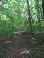
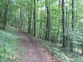
a steep footway
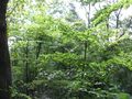
look into the hill
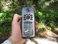
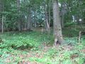
three meters to hash
there, at the stump
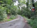
the junction
arrived!
the stump is five meters away
the north
the east
the south
the west
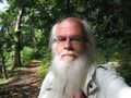
the geohasher
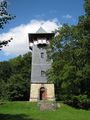
the tower
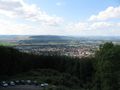
view to the southwestern part of Northeim


Achievements
GeorgDerReisende earned the Thumbs Up Geohash Achievement
|