Difference between revisions of "2017-10-07 52 -1"
imported>Pbro (Expedition page creation) |
imported>Pbro (Content bits) |
||
| Line 1: | Line 1: | ||
| + | [[User:Pbro|Pbro]] ([[User talk:Pbro|talk]]) discovered Stoke Green while looking for this hash. | ||
| − | |||
| − | [[Image:{{{image| | + | [[Image:{{{image|2017-10-07_52_-1_Lamppost.jpg }}}|thumb|left]] |
| − | |||
| − | |||
| − | |||
| − | |||
| − | |||
{{meetup graticule | {{meetup graticule | ||
| lat=52 | | lat=52 | ||
| lon=-1 | | lon=-1 | ||
| date=2017-10-07 | | date=2017-10-07 | ||
| + | | graticule_name=Birmingham | ||
| + | | graticule_link=Birmingham, United Kingdom | ||
}} | }} | ||
| Line 19: | Line 16: | ||
== Location == | == Location == | ||
| − | + | The hash is located on the eastern edge of Stoke Green, a small park in Coventry, UK. The hash is opposite 58 Stoke Green, Coventry CV3 1AN, at a side entrance to the Green. | |
== Participants == | == Participants == | ||
| − | + | [[User:Pbro|Pbro]] ([[User talk:Pbro|talk]]) went for a run, around 9k through south-eastern Coventry to get to this hash. | |
| − | |||
== Plans == | == Plans == | ||
| − | + | For [[User:Pbro|Pbro]] ([[User talk:Pbro|talk]]), another accessible Coventry hash in reasonable distance, reasonable autumn weather and a spare hour or so at 10 in the morning (and a urgent need to do some running). | |
== Expedition == | == Expedition == | ||
| − | + | After almost three weeks without running, I ([[User:Pbro|Pbro]] ([[User talk:Pbro|talk]])) needed to get out, so put on running gear, dropped off elder son at football and set out through parks, residential and commercial areas to the south-east of Coventry city centre. The run reached its destination near the junction of Stoke Green and Hollis Road. The hashpoint was located at a retro-design lamp post at a side entrance to Stoke Green. Stoke Green itself proved to be a green oasis in a mixed residential/commercial neighbourhood, with plenty of chestnut trees. The park is bordered by the busy Binley Road on the north and the eponymous road on the other sides. After a small run through the park, the return trip along a similar route brought me back home. | |
== Tracklog == | == Tracklog == | ||
| − | + | [https://connect.garmin.com/modern/activity/2062988227 Garmin track log] -- with a small operator error on the return trip. In total, the run was probably around 9k. | |
== Photos == | == Photos == | ||
| − | + | ||
| − | + | ||
| − | |||
<gallery perrow="5"> | <gallery perrow="5"> | ||
| + | Image:2017-10-07_52_-1_Lamppost.jpg | The hash - no fauns sighted. | ||
| + | Image:2017-10-07_52_-1_Screenshot.png | The proof - coordinates reached | ||
| + | Image:2017-10-07_52_-1_selfie.jpg | On a run. | ||
| + | Image:2017-10-07_52_-1_Stoke_Green.jpg | The park | ||
| + | Image:2017-10-07_52_-1_Sign.jpg | Road sign for Stoke Green | ||
</gallery> | </gallery> | ||
| − | + | ||
| − | |||
| − | |||
<!-- =============== USEFUL CATEGORIES FOLLOW ================ | <!-- =============== USEFUL CATEGORIES FOLLOW ================ | ||
| Line 51: | Line 49: | ||
<!-- ==REQUEST FOR TWITTER BOT== Please leave either the New report or the Expedition planning category in as long as you work on it. This helps the twitter bot a lot with announcing the right outcome at the right moment. --> | <!-- ==REQUEST FOR TWITTER BOT== Please leave either the New report or the Expedition planning category in as long as you work on it. This helps the twitter bot a lot with announcing the right outcome at the right moment. --> | ||
| − | + | ||
| − | |||
| − | |||
| − | |||
<!-- If all those plans are never acted upon, change [[Category:Expedition planning]] to [[Category:Not reached - Did not attempt]]. --> | <!-- If all those plans are never acted upon, change [[Category:Expedition planning]] to [[Category:Not reached - Did not attempt]]. --> | ||
| − | |||
[[Category:Expeditions]] | [[Category:Expeditions]] | ||
| − | + | ||
[[Category:Expeditions with photos]] | [[Category:Expeditions with photos]] | ||
| − | |||
| − | |||
| − | |||
| − | |||
[[Category:Coordinates reached]] | [[Category:Coordinates reached]] | ||
| − | |||
| − | |||
| − | |||
| − | |||
| − | |||
| − | |||
| − | |||
| − | |||
| − | |||
| − | |||
| − | |||
| − | |||
| − | |||
| − | |||
| − | |||
| − | |||
| − | |||
| − | |||
Revision as of 22:39, 7 October 2017
Pbro (talk) discovered Stoke Green while looking for this hash.

| Sat 7 Oct 2017 in Birmingham: 52.4039146, -1.4815994 geohashing.info google osm bing/os kml crox |
Location
The hash is located on the eastern edge of Stoke Green, a small park in Coventry, UK. The hash is opposite 58 Stoke Green, Coventry CV3 1AN, at a side entrance to the Green.
Participants
Pbro (talk) went for a run, around 9k through south-eastern Coventry to get to this hash.
Plans
For Pbro (talk), another accessible Coventry hash in reasonable distance, reasonable autumn weather and a spare hour or so at 10 in the morning (and a urgent need to do some running).
Expedition
After almost three weeks without running, I (Pbro (talk)) needed to get out, so put on running gear, dropped off elder son at football and set out through parks, residential and commercial areas to the south-east of Coventry city centre. The run reached its destination near the junction of Stoke Green and Hollis Road. The hashpoint was located at a retro-design lamp post at a side entrance to Stoke Green. Stoke Green itself proved to be a green oasis in a mixed residential/commercial neighbourhood, with plenty of chestnut trees. The park is bordered by the busy Binley Road on the north and the eponymous road on the other sides. After a small run through the park, the return trip along a similar route brought me back home.
Tracklog
Garmin track log -- with a small operator error on the return trip. In total, the run was probably around 9k.
Photos

The hash - no fauns sighted.

The proof - coordinates reached

On a run.
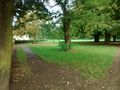
The park
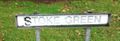
Road sign for Stoke Green


