Difference between revisions of "2017-10-07 52 -1"
imported>Pbro (Content bits) |
imported>Pbro (No longer work in progress - page is finished) |
||
| Line 43: | Line 43: | ||
| − | |||
| − | |||
| − | |||
| − | |||
| − | |||
| − | |||
| − | |||
| − | |||
[[Category:Expeditions]] | [[Category:Expeditions]] | ||
Revision as of 22:45, 7 October 2017
Pbro (talk) discovered Stoke Green while looking for this hash.

| Sat 7 Oct 2017 in Birmingham: 52.4039146, -1.4815994 geohashing.info google osm bing/os kml crox |
Location
The hash is located on the eastern edge of Stoke Green, a small park in Coventry, UK. The hash is opposite 58 Stoke Green, Coventry CV3 1AN, at a side entrance to the Green.
Participants
Pbro (talk) went for a run, around 9k through south-eastern Coventry to get to this hash.
Plans
For Pbro (talk), another accessible Coventry hash in reasonable distance, reasonable autumn weather and a spare hour or so at 10 in the morning (and a urgent need to do some running).
Expedition
After almost three weeks without running, I (Pbro (talk)) needed to get out, so put on running gear, dropped off elder son at football and set out through parks, residential and commercial areas to the south-east of Coventry city centre. The run reached its destination near the junction of Stoke Green and Hollis Road. The hashpoint was located at a retro-design lamp post at a side entrance to Stoke Green. Stoke Green itself proved to be a green oasis in a mixed residential/commercial neighbourhood, with plenty of chestnut trees. The park is bordered by the busy Binley Road on the north and the eponymous road on the other sides. After a small run through the park, the return trip along a similar route brought me back home.
Tracklog
Garmin track log -- with a small operator error on the return trip. In total, the run was probably around 9k.
Photos
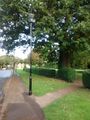
The hash - no fauns sighted.
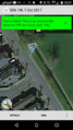
The proof - coordinates reached

On a run.
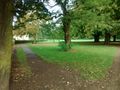
The park
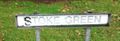
Road sign for Stoke Green


