Difference between revisions of "2017-10-09 49 8"
imported>DODO (Created page with "{{subst:Expedition |lat = 49 |lon = 8 |date = 2017-10-09 }}") |
imported>DODO |
||
| Line 20: | Line 20: | ||
== Location == | == Location == | ||
<!-- where you've surveyed the hash to be --> | <!-- where you've surveyed the hash to be --> | ||
| + | A path between Altlußheim and Rheinhausen | ||
== Participants == | == Participants == | ||
<!-- who attended: If you link to your wiki user name in this section, your expedition will be picked up by the various statistics generated for geohashing. You may use three tildes ~ as a shortcut to automatically insert the user signature of the account you are editing with. | <!-- who attended: If you link to your wiki user name in this section, your expedition will be picked up by the various statistics generated for geohashing. You may use three tildes ~ as a shortcut to automatically insert the user signature of the account you are editing with. | ||
--> | --> | ||
| + | [[User:DODO|DODO]] | ||
== Plans == | == Plans == | ||
<!-- what were the original plans --> | <!-- what were the original plans --> | ||
| + | Go there after work. | ||
| + | |||
| + | I havn't really gone, but was in so much work, and leisure that I didn't found any time for hashing in the last 99 days. But things are going to normalize during winter and so I hope to find some nice hashes in the nearer future. | ||
== Expedition == | == Expedition == | ||
<!-- how it all turned out. your narrative goes here. --> | <!-- how it all turned out. your narrative goes here. --> | ||
| − | + | Well, it's not that easy with that "having more time" thing. First, I needed two days to write a report and now I don't even have the time to do that right. But I will tell you more soon. Promise. | |
== Tracklog == | == Tracklog == | ||
<!-- if your GPS device keeps a log, you may post a link here --> | <!-- if your GPS device keeps a log, you may post a link here --> | ||
| − | + | [https://www.komoot.de/tour/23873405 2KM by foot] and 5 additional kilometers by car (not recorded) | |
== Photos == | == Photos == | ||
<!-- Insert pictures between the gallery tags using the following format: | <!-- Insert pictures between the gallery tags using the following format: | ||
| Line 39: | Line 44: | ||
--> | --> | ||
<gallery perrow="5"> | <gallery perrow="5"> | ||
| + | Image:2017-10-09-49_9-1.jpg|where I left little car | ||
| + | Image:2017-10-09-49_9-2.jpg|first view to the hash (next to the trees in the background) | ||
| + | Image:2017-10-09-49_9-8.png|proof | ||
| + | Image:2017-10-09-49_9-3.jpg|view to the west (path) | ||
| + | Image:2017-10-09-49_9-4.jpg|the south: nuclear power plant of Philippsburg in the background) | ||
| + | Image:2017-10-09-49_9-5.jpg|and east (path again) | ||
| + | Image:2017-10-09-49_9-6.jpg|the north(woods) | ||
| + | Image:2017-10-09-49_9-7.jpg|and the hasher | ||
</gallery> | </gallery> | ||
== Achievements == | == Achievements == | ||
{{#vardefine:ribbonwidth|800px}} | {{#vardefine:ribbonwidth|800px}} | ||
| − | + | {{land geohash | |
| + | | latitude = 49 | ||
| + | | longitude = 8 | ||
| + | | date = 2017-10-09 | ||
| + | | name = DODO | ||
| + | }} | ||
| − | |||
| − | |||
| − | |||
| − | |||
| − | |||
| − | |||
| − | |||
| − | |||
| − | |||
| − | |||
| − | |||
| − | |||
| − | |||
| − | |||
[[Category:Expeditions]] | [[Category:Expeditions]] | ||
| − | |||
| − | |||
| − | |||
| − | |||
| − | |||
| − | |||
| − | |||
[[Category:Coordinates reached]] | [[Category:Coordinates reached]] | ||
| − | |||
| − | |||
| − | |||
| − | |||
| − | |||
| − | |||
| − | |||
| − | |||
| − | |||
| − | |||
| − | |||
| − | |||
| − | |||
| − | |||
| − | |||
| − | |||
| − | |||
| − | |||
Revision as of 18:03, 11 October 2017
| Mon 9 Oct 2017 in 49,8: 49.2830050, 8.4986228 geohashing.info google osm bing/os kml crox |
Location
A path between Altlußheim and Rheinhausen
Participants
Plans
Go there after work.
I havn't really gone, but was in so much work, and leisure that I didn't found any time for hashing in the last 99 days. But things are going to normalize during winter and so I hope to find some nice hashes in the nearer future.
Expedition
Well, it's not that easy with that "having more time" thing. First, I needed two days to write a report and now I don't even have the time to do that right. But I will tell you more soon. Promise.
Tracklog
2KM by foot and 5 additional kilometers by car (not recorded)
Photos
where I left little car
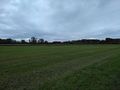
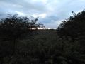
first view to the hash (next to the trees in the background)
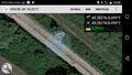
proof
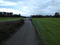
view to the west (path)
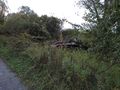
the south: nuclear power plant of Philippsburg in the background)
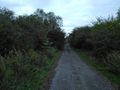
and east (path again)
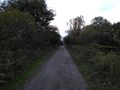
the north(woods)
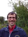
and the hasher


Achievements
DODO earned the Land geohash achievement
|