Difference between revisions of "2017-10-31 49 8"
imported>DODO (Created page with " {{subst:Expedition |lat = 49 |lon = 8 |date = 2017-10-31 }}") |
imported>FippeBot m (Location) |
||
| (5 intermediate revisions by one other user not shown) | |||
| Line 22: | Line 22: | ||
== Location == | == Location == | ||
<!-- where you've surveyed the hash to be --> | <!-- where you've surveyed the hash to be --> | ||
| + | Next to a brook near Eichelberg. | ||
== Participants == | == Participants == | ||
<!-- who attended: If you link to your wiki user name in this section, your expedition will be picked up by the various statistics generated for geohashing. You may use three tildes ~ as a shortcut to automatically insert the user signature of the account you are editing with. | <!-- who attended: If you link to your wiki user name in this section, your expedition will be picked up by the various statistics generated for geohashing. You may use three tildes ~ as a shortcut to automatically insert the user signature of the account you are editing with. | ||
--> | --> | ||
| − | + | [[User:DODO|DODO]] | |
== Plans == | == Plans == | ||
<!-- what were the original plans --> | <!-- what were the original plans --> | ||
| + | Go there by bull. | ||
== Expedition == | == Expedition == | ||
<!-- how it all turned out. your narrative goes here. --> | <!-- how it all turned out. your narrative goes here. --> | ||
| + | Started on my bull at half past one and planned a tron. The tour was nice but uneventfull (at least I had rode most of the way on earlier hashtours). After 75 minutes I reached a viaduct (an earlier train-track) and had the first view to the hash. Around 20 m below. | ||
| + | |||
| + | I parked the bull and walked back to the road. There was some grassland that became more and more wet, the lower I came. In the end I had to walk carefully from one taft of grass to the next to avoid wet feet. Then the grassland ended, and was replaced by a light copse. I found a stump with some branches fixed manually on it. And it marked the exact position of the hash. So I'm surprised that noone else had written here yet. | ||
| + | |||
| + | On my way back my tablet ran out of battery so I have no proof of the tron. I soon started my cellphone to track my way but there is still a remarkable gap. | ||
== Tracklog == | == Tracklog == | ||
<!-- if your GPS device keeps a log, you may post a link here --> | <!-- if your GPS device keeps a log, you may post a link here --> | ||
| + | [https://www.komoot.de/tour/24739835 First 49 KM] and [https://www.komoot.de/tour/24727040 last 40 KM] of the 94 KM -tour. | ||
== Photos == | == Photos == | ||
| Line 40: | Line 48: | ||
Image:2012-##-## ## ## Alpha.jpg | Witty Comment | Image:2012-##-## ## ## Alpha.jpg | Witty Comment | ||
--> | --> | ||
| + | |||
<gallery perrow="5"> | <gallery perrow="5"> | ||
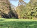
| + | Image:2017-10-31_49_8-1.jpg|somewhere down there | ||
| + | Image:2017-10-31_49_8-2.jpg|I left the bull up there | ||
| + | Image:2017-10-31_49_8-10.png|proof | ||
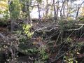
| + | Image:2017-10-31_49_8-3.jpg|I found this mark at the hash | ||
| + | Image:2017-10-31_49_8-4.jpg|view to the viaduct (and the east) | ||
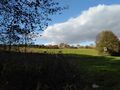
| + | Image:2017-10-31_49_8-5.jpg|the south | ||
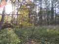
| + | Image:2017-10-31_49_8-7.jpg|the north | ||
| + | Image:2017-10-31_49_8-8.jpg|the west | ||
| + | Image:2017-10-31_49_8-9.jpg|and the hasher | ||
</gallery> | </gallery> | ||
| Line 47: | Line 65: | ||
<!-- Add any achievement ribbons you earned below, or remove this section --> | <!-- Add any achievement ribbons you earned below, or remove this section --> | ||
| − | + | {{land geohash | |
| − | + | | latitude = 49 | |
| − | + | | longitude = 8 | |
| + | | date = 2017-10-31 | ||
| + | | name = DODO | ||
| + | }} | ||
| − | + | {{consecutive geohash | |
| + | | count = 2 | ||
| + | | latitude = 49 | ||
| + | | longitude = 8 | ||
| + | | date = 2017-10-30 | ||
| + | | name = DODO | ||
| + | }} | ||
| − | + | [[Category:Expeditions]] | |
| − | |||
| − | [[Category: | ||
| − | |||
| − | |||
| − | |||
| − | |||
| − | |||
| − | |||
| − | |||
| − | |||
| − | |||
| − | |||
| − | |||
| − | |||
[[Category:Coordinates reached]] | [[Category:Coordinates reached]] | ||
| − | + | {{location|DE|BW|KA}} | |
| − | |||
| − | |||
| − | |||
| − | |||
| − | |||
| − | |||
| − | |||
| − | |||
| − | |||
| − | |||
| − | |||
| − | |||
| − | |||
| − | |||
| − | |||
| − | |||
| − | |||
Latest revision as of 03:05, 16 August 2019
| Tue 31 Oct 2017 in 49,8: 49.1849504, 8.8194132 geohashing.info google osm bing/os kml crox |
Location
Next to a brook near Eichelberg.
Participants
Plans
Go there by bull.
Expedition
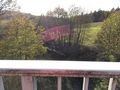
Started on my bull at half past one and planned a tron. The tour was nice but uneventfull (at least I had rode most of the way on earlier hashtours). After 75 minutes I reached a viaduct (an earlier train-track) and had the first view to the hash. Around 20 m below.
I parked the bull and walked back to the road. There was some grassland that became more and more wet, the lower I came. In the end I had to walk carefully from one taft of grass to the next to avoid wet feet. Then the grassland ended, and was replaced by a light copse. I found a stump with some branches fixed manually on it. And it marked the exact position of the hash. So I'm surprised that noone else had written here yet.
On my way back my tablet ran out of battery so I have no proof of the tron. I soon started my cellphone to track my way but there is still a remarkable gap.
Tracklog
First 49 KM and last 40 KM of the 94 KM -tour.
Photos
somewhere down there
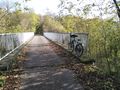
I left the bull up there
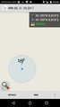
proof
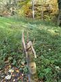
I found this mark at the hash
view to the viaduct (and the east)
the south
the north
the west
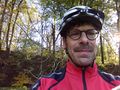
and the hasher


Achievements
DODO earned the Land geohash achievement
|
DODO earned the Consecutive geohash achievement
|