Difference between revisions of "2017-11-01 49 8"
From Geohashing
imported>DODO (→Photos) |
imported>FippeBot m (Location) |
||
| Line 83: | Line 83: | ||
[[Category:Coordinates reached]] | [[Category:Coordinates reached]] | ||
| + | {{location|DE|BW|KA}} | ||
Latest revision as of 03:05, 16 August 2019
| Wed 1 Nov 2017 in 49,8: 49.1326498, 8.3739918 geohashing.info google osm bing/os kml crox |
Location
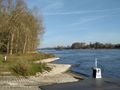
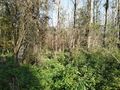
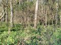
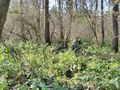
In the alluvial forrest next to the rhine close to Linkenheim.
Participants
Plans
Go there by bull in the morning.
Expedition
Started at home at 9:50 and rode southwards along the rhine. After an hour I reached the ferry at Leimersheim and crossed the river. The hash was only 2 KM away from the ferry. I rode back northwards on the other side and found the hash some 5 meters next to a path. Erected an improvised X and hurried back home where the lady was already waiting to go on a biketour.
Tracklog
Photos
Will follow
2 more kilometers, but on the other side
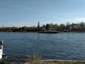
for heavens sake, there is a ferry
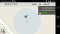
proof
view to the north
almost the same to the west
but to the south you can see a parking bull

and to the east, you see a happy hasher


Achievements
DODO earned the Land geohash achievement
|
DODO earned the Consecutive geohash achievement
|
DODO earned the Tron achievement
|