Difference between revisions of "2018-01-03 39 27"
imported>Sourcerer m (→Photos) |
imported>Sourcerer m (→Achievements) |
||
| Line 41: | Line 41: | ||
[[Category:Expeditions]] | [[Category:Expeditions]] | ||
[[Category:Expeditions with photos]] | [[Category:Expeditions with photos]] | ||
| − | [[Category:Coordinates reached]] | + | [[Category:Coordinates not reached]] |
Revision as of 17:08, 3 January 2018
| Tue 21 Nov 2017 in Balıkesir, Turkey: 39.2746358, 27.5898082 geohashing.info google osm bing/os kml crox |
Location
11 km above Hamidiye flying at over 800 km/h. Thanks, Ryanair - you missed the point by about 20 arc seconds.
Participants
Plans
All my journeys by air are Geohashing expeditions with a really low chance of success as these are scheduled flights and I'm not willing to attempt to persuade the crew to alter their course. That would be hijacking!
Expedition - Fail
Up to now, I've never got close but today the latitude was just under 20 arc seconds off and the longitude about 17 arc seconds wrong. The rule is to get to within 10 arc seconds so it's coordinates not reached but it was so close!
Photos
- Gallery

Google Earth track log.
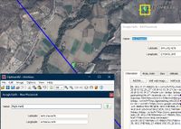
Proof of Flight (Stansted, UK to Paphos, Cyprus)


Achievements
Expeditions and Plans
| 2018-01-03 | ||
|---|---|---|
| Balıkesir, Turkey | Sourcerer | 11 km above Hamidiye flying at over 800 km/h. Thanks, Ryanair - you missed ... |
| McMinnville, Oregon | Jim | On a driveway south of Hillsboro |
Sourcerer's Expedition Links
2017-11-21 52 1 - 2018-01-03 39 27 - 2018-02-01 52 1 - KML file download of Sourcerer's expeditions for use with Google Earth.