Difference between revisions of "2018-01-11 29 -96"
From Geohashing
imported>Jiml (Fill in report areas from available data) |
imported>Jiml m (Fix damage to formatting) |
||
| Line 25: | Line 25: | ||
== Participants == | == Participants == | ||
| − | * | + | * [[User:Thunk|Thunk]] |
== Plans == | == Plans == | ||
| Line 38: | Line 38: | ||
*Hash attempt unsuccessful. Area fenced off. -- [[User:Thunk|Thunk]] ([[User talk:Thunk|talk]]) [http://www.openstreetmap.org/?lat=29.93337480&lon=-96.87355580&zoom=16&layers=B000FTF @29.9334,-96.8736] 22:22, 11 January 2018 (GMT+00:00) | *Hash attempt unsuccessful. Area fenced off. -- [[User:Thunk|Thunk]] ([[User talk:Thunk|talk]]) [http://www.openstreetmap.org/?lat=29.93337480&lon=-96.87355580&zoom=16&layers=B000FTF @29.9334,-96.8736] 22:22, 11 January 2018 (GMT+00:00) | ||
| − | = Photos == | + | == Photos == |
<gallery perrow="5"> | <gallery perrow="5"> | ||
Revision as of 20:53, 15 January 2018
| Thu 11 Jan 2018 in 29,-96: 29.9331669, -96.8731236 geohashing.info google osm bing/os kml crox |
Location
North of La Grange
Participants
Plans
Unknown
Expedition
- Hash attempt unsuccessful. Area fenced off. -- Thunk (talk) @29.9334,-96.8736 22:22, 11 January 2018 (GMT+00:00)
Photos
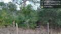
Fence @29.9334,-96.8736

Achievements
- No Trespassing