Difference between revisions of "2018-03-09 52 4"
imported>FelixTheCat (Created page with "{{subst:Expedition |lat = 52 |lon = 4 |date = 2018-03-09 }}") |
imported>FelixTheCat |
||
| Line 1: | Line 1: | ||
| − | |||
| − | |||
| − | |||
| − | |||
| − | |||
| − | |||
| − | |||
| − | |||
| − | |||
| − | |||
{{meetup graticule | {{meetup graticule | ||
| lat=52 | | lat=52 | ||
| Line 14: | Line 4: | ||
| date=2018-03-09 | | date=2018-03-09 | ||
}} | }} | ||
| − | |||
| − | |||
| − | |||
| − | |||
== Location == | == Location == | ||
| − | + | Pijnacker, South Holland province. | |
== Participants == | == Participants == | ||
| − | + | [[User:FelixTheCat|FelixTheCat]] ([[User talk:FelixTheCat|talk]]) | |
| − | |||
| − | |||
| − | |||
| − | |||
== Expedition == | == Expedition == | ||
| − | + | Today's hash was about 5 km east of my office. So after work I got on my bike and rode to the east, arriving in Pijnacker after about 15 minutes. Pijnacker used to be a small village, but has grown immensely in the past decade or so to relieve some pressure from the housing market in surrounding areas (Delft, Rotterdam, The Hague). So my cycling trip mostly took me past long rows of brand new suburban housing. Right at the edge of the town I found the field where the hash was located. At first I couldn't get onto the field because there were several drainage ditches blocking the way, but luckily I found a little bridge that took me right across to the correct area. Usually such fields are the private property of a nearby farmer, but there were no fences or signs blocking the way and the fields did not appear to be in use by anyone. This area would probably have been destined to be filled with even more houses, were it not for the fact that a (brand new) high voltage line was running right across it. I found the hash, took some pictures (with my phone, because I forgot to bring my camera) and went home. | |
| − | |||
| − | |||
| − | |||
== Photos == | == Photos == | ||
| − | |||
| − | |||
| − | |||
<gallery perrow="5"> | <gallery perrow="5"> | ||
| + | Image:2018-03-09 52 4 FelixTheCat 1.JPG | The hash field. Water blocks my way. The hash is on the other side, where the grass is greener. | ||
| + | Image:2018-03-09 52 4 FelixTheCat 2.JPG | But near those houses there's a little bridge. Now the hash is straight ahead, about 100 metres from here. | ||
| + | Image:2018-03-09 52 4 FelixTheCat 3.png | Made it! | ||
| + | Image:2018-03-09 52 4 FelixTheCat 4.JPG | Lloyd celebrating. The ground is rather soggy. | ||
| + | Image:2018-03-09 52 4 FelixTheCat 5.JPG | Looking southwest, towards more suburban housing. | ||
| + | Image:2018-03-09 52 4 FelixTheCat 6.JPG | Looking southeast, towards a high voltage line (380 kV) with modern, slim pylons. | ||
</gallery> | </gallery> | ||
== Achievements == | == Achievements == | ||
{{#vardefine:ribbonwidth|800px}} | {{#vardefine:ribbonwidth|800px}} | ||
| − | + | {{bicycle geohash | |
| − | + | | latitude = 52 | |
| − | + | | longitude = 4 | |
| − | + | | date = 2018-03-09 | |
| − | + | | name = [[User:FelixTheCat|FelixTheCat]] ([[User talk:FelixTheCat|talk]]) | |
| − | + | | distance = 5 km | |
| − | + | }} | |
| − | |||
| − | |||
| − | |||
| − | |||
| − | |||
| − | |||
| − | |||
| − | |||
| − | |||
[[Category:Expeditions]] | [[Category:Expeditions]] | ||
| − | |||
[[Category:Expeditions with photos]] | [[Category:Expeditions with photos]] | ||
| − | |||
| − | |||
| − | |||
| − | |||
| − | |||
[[Category:Coordinates reached]] | [[Category:Coordinates reached]] | ||
| − | |||
| − | |||
| − | |||
| − | |||
| − | |||
| − | |||
| − | |||
| − | |||
| − | |||
| − | |||
| − | |||
| − | |||
| − | |||
| − | |||
| − | |||
| − | |||
| − | |||
| − | |||
Revision as of 21:58, 9 March 2018
| Fri 9 Mar 2018 in 52,4: 52.0124376, 4.4550088 geohashing.info google osm bing/os kml crox |
Location
Pijnacker, South Holland province.
Participants
Expedition
Today's hash was about 5 km east of my office. So after work I got on my bike and rode to the east, arriving in Pijnacker after about 15 minutes. Pijnacker used to be a small village, but has grown immensely in the past decade or so to relieve some pressure from the housing market in surrounding areas (Delft, Rotterdam, The Hague). So my cycling trip mostly took me past long rows of brand new suburban housing. Right at the edge of the town I found the field where the hash was located. At first I couldn't get onto the field because there were several drainage ditches blocking the way, but luckily I found a little bridge that took me right across to the correct area. Usually such fields are the private property of a nearby farmer, but there were no fences or signs blocking the way and the fields did not appear to be in use by anyone. This area would probably have been destined to be filled with even more houses, were it not for the fact that a (brand new) high voltage line was running right across it. I found the hash, took some pictures (with my phone, because I forgot to bring my camera) and went home.
Photos
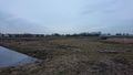
The hash field. Water blocks my way. The hash is on the other side, where the grass is greener.
But near those houses there's a little bridge. Now the hash is straight ahead, about 100 metres from here.
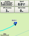
Made it!
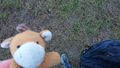
Lloyd celebrating. The ground is rather soggy.
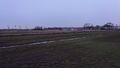
Looking southwest, towards more suburban housing.
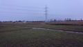
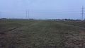
Looking southeast, towards a high voltage line (380 kV) with modern, slim pylons.


Achievements
FelixTheCat (talk) earned the Bicycle geohash achievement
|