Difference between revisions of "2018-03-25 49 8"
imported>DODO (→Expedition) |
imported>FippeBot m (Location) |
||
| (4 intermediate revisions by one other user not shown) | |||
| Line 42: | Line 42: | ||
== Tracklog == | == Tracklog == | ||
<!-- if your GPS device keeps a log, you may post a link here --> | <!-- if your GPS device keeps a log, you may post a link here --> | ||
| + | [https://www.komoot.de/tour/28202250/zoom 78 KM on the bull] | ||
== Photos == | == Photos == | ||
| Line 48: | Line 49: | ||
--> | --> | ||
<gallery perrow="5"> | <gallery perrow="5"> | ||
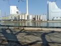
| + | Image:2018-03-25_49_8-1.jpg|This ferry again (on the other side of the rhine | ||
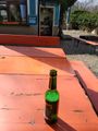
| + | Image:2018-03-25_49_8-2.jpg|consolation for the missed ferry | ||
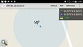
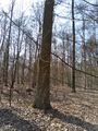
| + | Image:2018-03-25_49_8-9.jpg|proof | ||
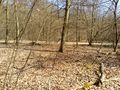
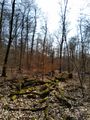
| + | Image:2018-03-25_49_8-3.jpg|view to the east - bull in the background | ||
| + | Image:2018-03-25_49_8-4.jpg|to the south | ||
| + | Image:2018-03-25_49_8-5.jpg|and the west | ||
| + | Image:2018-03-25_49_8-6.jpg|hasher - happy | ||
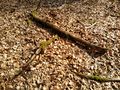
| + | Image:2018-03-25_49_8-7.jpg|kind of X | ||
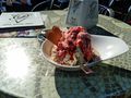
| + | Image:2018-03-25_49_8-8.jpg|ice-cream :-) | ||
</gallery> | </gallery> | ||
== Achievements == | == Achievements == | ||
{{#vardefine:ribbonwidth|800px}} | {{#vardefine:ribbonwidth|800px}} | ||
| − | + | No tron, so it's just | |
| − | + | {{land geohash | |
| − | + | | latitude = 49 | |
| − | + | | longitude = 8 | |
| + | | date = 2018-03-25 | ||
| + | | name = DODO | ||
| + | }} | ||
| − | |||
| − | |||
| − | |||
| − | |||
| − | |||
| − | |||
| − | |||
| − | |||
| − | |||
[[Category:Expeditions]] | [[Category:Expeditions]] | ||
| − | |||
| − | |||
| − | |||
| − | |||
| − | |||
| − | |||
| − | |||
[[Category:Coordinates reached]] | [[Category:Coordinates reached]] | ||
| − | + | {{location|DE|HE|HP}} | |
| − | |||
| − | |||
| − | |||
| − | |||
| − | |||
| − | |||
| − | |||
| − | |||
| − | |||
| − | |||
| − | |||
| − | |||
| − | |||
| − | |||
| − | |||
| − | |||
| − | |||
Latest revision as of 03:25, 16 August 2019
| Sun 25 Mar 2018 in 49,8: 49.5794131, 8.5692769 geohashing.info google osm bing/os kml crox |
Location
Another hash in the forest north of Mannheim.
Participants
Plans
Go there by bull. Will start around high noon (MESZ) and arrive before 2 pm.
Expedition
I started at 12:02 and had a really nice ride in the bright sunshine. After half an hour I reached the ferry, which was just leaving. There was a little shop next to the ferry, and I had at least ten minutes time. So I decided for a beer in the sunshine. After I've crossed the rhine, I had to ride through Mannheim, not the most beautiful part to ride. But at half past one I finally reached the forest. 20 minutes later I was close to the hash. I just had to go 20 m into the light forest. I took some pictures and rearranged some wood to build an X before I returned to the bull and continued my way.
I had made some effort to reach a tron, and the track looks pretty nice but when I had to cross the river Neckar again, I took a wrong switch and rode through an underbridge. Well just under the bridge I had to cross :-( But on the other hand, after this I was free to take a little detour to get an ice-cream :-)
I reached home at 15:40 again.
Tracklog
Photos
This ferry again (on the other side of the rhine
consolation for the missed ferry
proof
view to the east - bull in the background
to the south
and the west

hasher - happy
kind of X
ice-cream :-)


Achievements
No tron, so it's just
DODO earned the Land geohash achievement
|