Difference between revisions of "2018-03-31 49 8"
From Geohashing
imported>DODO (→Photos) |
imported>DODO (→Achievements) |
||
| Line 57: | Line 57: | ||
{{#vardefine:ribbonwidth|800px}} | {{#vardefine:ribbonwidth|800px}} | ||
<!-- Add any achievement ribbons you earned below, or remove this section --> | <!-- Add any achievement ribbons you earned below, or remove this section --> | ||
| + | Just land today, but that may change tomorrow | ||
| + | {{land geohash | ||
| + | | latitude = 49 | ||
| + | | longitude = 8 | ||
| + | | date = 2018-03-31 | ||
| + | | name = DODO | ||
| + | }} | ||
| − | |||
| − | |||
| − | |||
| − | |||
| − | |||
| − | |||
| − | |||
| − | |||
| − | |||
| − | |||
[[Category:Expeditions]] | [[Category:Expeditions]] | ||
| − | |||
| − | |||
| − | |||
| − | |||
| − | |||
| − | |||
| − | |||
[[Category:Coordinates reached]] | [[Category:Coordinates reached]] | ||
| − | |||
| − | |||
| − | |||
| − | |||
| − | |||
| − | |||
| − | |||
| − | |||
| − | |||
| − | |||
| − | |||
| − | |||
| − | |||
| − | |||
| − | |||
| − | |||
| − | |||
| − | |||
Revision as of 14:28, 31 March 2018
| Sat 31 Mar 2018 in 49,8: 49.3222345, 8.6667685 geohashing.info google osm bing/os kml crox |
Location
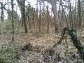
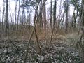
In a small peace of wood south of Sankt Ilgen.
Participants
Plans
Go there by bull in the afternoon. I have to do the shopping first, so I'm not sure, when I can start. Try to be there at hash o'clock. Will start soon (arounf 2 pm) and hope to arrive in an hour.
Expedition
Just a 2 hours ride and a 50 m walk in the warm sunny springtime.
Tracklog
Photos
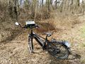
bull, 25 m apart
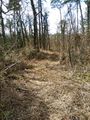
25 m into this thorny path
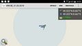
proof
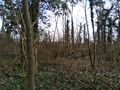
view to the west
to the north (and the path)
to the east

and to the south (nad the happy hasher)


Achievements
Just land today, but that may change tomorrow
DODO earned the Land geohash achievement
|