Difference between revisions of "2018-04-08 52 5"
imported>FelixTheCat (Created page with "{{subst:Expedition |lat = 52 |lon = 5 |date = 2018-04-08 }}") |
imported>FelixTheCat |
||
| Line 1: | Line 1: | ||
| − | |||
| − | |||
| − | |||
| − | |||
| − | |||
| − | |||
| − | |||
| − | |||
| − | |||
| − | |||
{{meetup graticule | {{meetup graticule | ||
| lat=52 | | lat=52 | ||
| Line 14: | Line 4: | ||
| date=2018-04-08 | | date=2018-04-08 | ||
}} | }} | ||
| − | |||
| − | |||
__NOTOC__ | __NOTOC__ | ||
| − | |||
== Location == | == Location == | ||
| − | + | In a forest near Leusden, Utrecht province. | |
== Participants == | == Participants == | ||
| − | + | [[User:FelixTheCat|FelixTheCat]] ([[User talk:FelixTheCat|talk]]) | |
| − | |||
| − | |||
| − | |||
| − | |||
== Expedition == | == Expedition == | ||
| − | + | I took a slight detour on my way to another appointment to visit this hash on a Sunday morning. I parked the hashmobile in a little car park at the entrance to the forest. I then walked for about 15 minutes through a suprisingly varied landscape. Once at the hash it was tricky to get a stable reading on my GPS, but I did manage to get a zero reading. When I got back to the car park it was suddenly completely packed with cars, apparently belonging to a group of runners preparing for a run (I suppose) in the forest. | |
| − | |||
| − | |||
| − | |||
== Photos == | == Photos == | ||
| − | |||
| − | |||
| − | |||
<gallery perrow="5"> | <gallery perrow="5"> | ||
| + | Image:2018-04-08 52 5 FelixTheCat 1.JPG | Walking towards a small hill. | ||
| + | Image:2018-04-08 52 5 FelixTheCat 2.JPG | The view from atop said hill. There's trees, sand, shrubs and lots more to see. | ||
| + | Image:2018-04-08 52 5 FelixTheCat 3.JPG | A bit of forest with some younger trees. | ||
| + | Image:2018-04-08 52 5 FelixTheCat 4.JPG | The hash is somewhere up ahead. | ||
| + | Image:2018-04-08 52 5 FelixTheCat 5.JPG | Right here, in fact. | ||
| + | Image:2018-04-08 52 5 FelixTheCat 6.png | GPS proof. | ||
| + | Image:2018-04-08 52 5 FelixTheCat 7.JPG | Lloyd posing at the hash. | ||
| + | Image:2018-04-08 52 5 FelixTheCat 8.JPG | View to the west. | ||
</gallery> | </gallery> | ||
== Achievements == | == Achievements == | ||
{{#vardefine:ribbonwidth|800px}} | {{#vardefine:ribbonwidth|800px}} | ||
| − | + | {{land geohash | |
| − | + | | latitude = 52 | |
| − | + | | longitude = 5 | |
| − | + | | date = 2018-04-08 | |
| − | + | | name = [[User:FelixTheCat|FelixTheCat]] ([[User talk:FelixTheCat|talk]]) | |
| − | + | }} | |
| − | |||
| − | |||
| − | |||
| − | |||
| − | |||
| − | |||
| − | |||
| − | |||
| − | |||
| − | |||
[[Category:Expeditions]] | [[Category:Expeditions]] | ||
| − | |||
[[Category:Expeditions with photos]] | [[Category:Expeditions with photos]] | ||
| − | |||
| − | |||
| − | |||
| − | |||
| − | |||
[[Category:Coordinates reached]] | [[Category:Coordinates reached]] | ||
| − | |||
| − | |||
| − | |||
| − | |||
| − | |||
| − | |||
| − | |||
| − | |||
| − | |||
| − | |||
| − | |||
| − | |||
| − | |||
| − | |||
| − | |||
| − | |||
| − | |||
| − | |||
Revision as of 20:17, 10 April 2018
| Sun 8 Apr 2018 in 52,5: 52.0976469, 5.3801425 geohashing.info google osm bing/os kml crox |
Location
In a forest near Leusden, Utrecht province.
Participants
Expedition
I took a slight detour on my way to another appointment to visit this hash on a Sunday morning. I parked the hashmobile in a little car park at the entrance to the forest. I then walked for about 15 minutes through a suprisingly varied landscape. Once at the hash it was tricky to get a stable reading on my GPS, but I did manage to get a zero reading. When I got back to the car park it was suddenly completely packed with cars, apparently belonging to a group of runners preparing for a run (I suppose) in the forest.
Photos
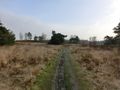
Walking towards a small hill.
The view from atop said hill. There's trees, sand, shrubs and lots more to see.
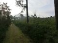
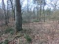
A bit of forest with some younger trees.
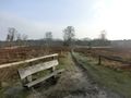
The hash is somewhere up ahead.
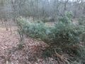
Right here, in fact.
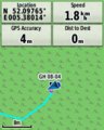
GPS proof.
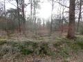
Lloyd posing at the hash.
View to the west.


Achievements
FelixTheCat (talk) earned the Land geohash achievement
|