Difference between revisions of "2018-05-21 51 9"
From Geohashing
imported>GeorgDerReisende (new report) |
imported>FippeBot m (Location) |
||
| (One intermediate revision by one other user not shown) | |||
| Line 1: | Line 1: | ||
| − | |||
| − | |||
| − | |||
| − | |||
| − | |||
| − | |||
| − | |||
| − | |||
| − | |||
| − | |||
{{meetup graticule | {{meetup graticule | ||
| lat=51 | | lat=51 | ||
| Line 19: | Line 9: | ||
== Location == | == Location == | ||
| − | + | ||
| + | The hash lay between a lake and a lane at Höxter-Godelheim. | ||
== Participants == | == Participants == | ||
| − | + | ||
| − | + | [[User:GeorgDerReisende|GeorgDerReisende]] | |
== Plans == | == Plans == | ||
| − | + | ||
| + | This time I had to take the whole distance by public transport. | ||
== Expedition == | == Expedition == | ||
| − | |||
| − | + | With the tram, the regiotram, a bus and two trains I travelled to Höxter. From the railway station I walked along the river Weser and former gravel mining lakes to the hash. At the hash there were hard grass and young trees. There was a little dance, but I got it. From home to hash 5 1/4 hours. | |
| − | |||
== Photos == | == Photos == | ||
| Line 39: | Line 29: | ||
--> | --> | ||
<gallery perrow="5"> | <gallery perrow="5"> | ||
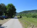
| + | Image:2018-05-21 51 9 GeorgDerReisende 1833.jpg | on the left side of the lane, 200 meters ahead | ||
| + | Image:2018-05-21 51 9 GeorgDerReisende 1834.jpg | there! | ||
| + | Image:2018-05-21 51 9 GeorgDerReisende 1835.jpg | there, nearer | ||
| + | Image:2018-05-21 51 9 GeorgDerReisende 1838.jpg | proof | ||
| + | Image:2018-05-21 51 9 GeorgDerReisende 1839.jpg | looking to the south | ||
| + | Image:2018-05-21 51 9 GeorgDerReisende 1840.jpg | the north, with the lake behind the trees | ||
| + | Image:2018-05-21 51 9 GeorgDerReisende 1841.jpg | the west | ||
| + | Image:2018-05-21 51 9 GeorgDerReisende 1842.jpg | the east | ||
| + | Image:2018-05-21 51 9 GeorgDerReisende 1843.jpg | the geohasher | ||
| + | Image:2018-05-21 51 9 GeorgDerReisende 1848.jpg | better view to the lake of the north | ||
| + | Image:2018-05-21 51 9 GeorgDerReisende 1849.jpg | looking back to the west | ||
| + | Image:2018-05-21 51 9 GeorgDerReisende 1851.jpg | on the southern side there is a lake, too | ||
</gallery> | </gallery> | ||
| Line 45: | Line 47: | ||
<!-- Add any achievement ribbons you earned below, or remove this section --> | <!-- Add any achievement ribbons you earned below, or remove this section --> | ||
| − | + | {{Geohashing Day | latitude = 51 | longitude = 9 | year = 2018 | coorddate = 2018-05-21 | name = GeorgDerReisende }} | |
| − | |||
| − | |||
| − | + | [[Category:Expeditions]] | |
| − | + | [[Category:Expeditions with photos]] | |
| − | |||
| − | [[Category: | ||
| − | |||
| − | |||
| − | |||
| − | |||
| − | |||
| − | |||
| − | |||
| − | |||
| − | |||
| − | |||
| − | |||
| − | |||
[[Category:Coordinates reached]] | [[Category:Coordinates reached]] | ||
| − | + | {{location|DE|NW|HX}} | |
| − | |||
| − | |||
| − | |||
| − | |||
| − | |||
| − | |||
| − | |||
| − | |||
| − | |||
| − | |||
| − | |||
| − | |||
| − | |||
| − | |||
| − | |||
| − | |||
| − | |||
Latest revision as of 03:39, 16 August 2019
| Mon 21 May 2018 in 51,9: 51.7499123, 9.3766712 geohashing.info google osm bing/os kml crox |
Location
The hash lay between a lake and a lane at Höxter-Godelheim.
Participants
Plans
This time I had to take the whole distance by public transport.
Expedition
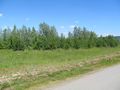
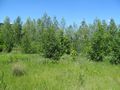
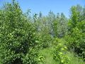
With the tram, the regiotram, a bus and two trains I travelled to Höxter. From the railway station I walked along the river Weser and former gravel mining lakes to the hash. At the hash there were hard grass and young trees. There was a little dance, but I got it. From home to hash 5 1/4 hours.
Photos
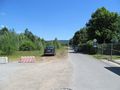
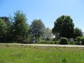
on the left side of the lane, 200 meters ahead
there!
there, nearer
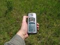
proof
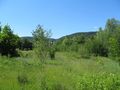
looking to the south
the north, with the lake behind the trees
the west
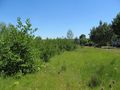
the east
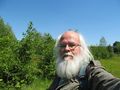
the geohasher
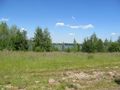
better view to the lake of the north
looking back to the west
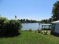
on the southern side there is a lake, too


Achievements
GeorgDerReisende earned the 2018 Geohashing Day achievement
|