Difference between revisions of "2018-06-16 -35 149"
imported>Felix Dance ([live picture]GPS proof :)) |
imported>FippeBot m (Location) |
||
| (8 intermediate revisions by one other user not shown) | |||
| Line 1: | Line 1: | ||
| − | |||
| − | |||
| − | |||
| − | |||
| − | |||
| − | |||
| − | |||
| − | |||
| − | |||
{{meetup graticule | {{meetup graticule | ||
| lat=-35 | | lat=-35 | ||
| Line 14: | Line 5: | ||
| date=2018-06-16 | | date=2018-06-16 | ||
}} | }} | ||
| − | |||
| − | |||
| − | |||
== Location == | == Location == | ||
| − | + | Next to Halls creek near the town of Hall, adjacent to the NSW border | |
== Participants == | == Participants == | ||
| − | + | [[User:Felix Dance|Felix Dance]] | |
| − | |||
| − | == | + | == Expedition == |
| − | + | I'm writing this one up a couple of months later, but the general gist is that I had an afternoon free on a Saturday after work and while my girlfriend was seeing a friend - so I hashed. | |
| − | + | This time of year it's pretty cold and miserable in Canberra, and sure enough, half-way out along the bike paths to the hash a large and unexpected thunderstorm rolled through, wetting me. | |
| − | + | ||
| + | At last I got to the hash area, but, in defiance of the minimal research I'd undertaken online, it seemed inaccessible. Three layers of fences of varying heights and barbiness separated me from the hash-paddock, with more looming in the distance. I despaired. | ||
| + | |||
| + | Thankfully, the first fence featured a fallen tree, which allowed me to climb across. The next barbed-wire fence was low enough to carefully step over. Finally, the very-tall fence inside this one was circumnavigable, so I just walked around, entering a strange, empty paddock. Eventually, I climbed another tall fence to reach the creek and travelled down this for a few hundred metres. A brief jump and I was over, and locating the hash. I saw kangaroos and enjoyed the fine raindrops, taking photos with my phone's self-cam. I was pretty elated and getting here. | ||
| + | |||
| + | I left the way I came and managed to get over the last fence only seconds before a landrover drove past along the inside fence. The return was almost unbearable on my bike fingers, and it took hours for them to warm back up. | ||
| + | |||
| + | [https://goo.gl/maps/KnePc6fkChH2 Here] is the route I took. | ||
| − | == | + | *Arrived wet geohash location -- [[User:Felix Dance|Felix Dance]] ([[User talk:Felix Dance|talk]]) [http://www.openstreetmap.org/?lat=-35.18459780&lon=149.05268800&zoom=16&layers=B000FTF @-35.1846,149.0527] 15:24, 16 June 2018 (GMT+10:00) |
| − | |||
== Photos == | == Photos == | ||
| − | |||
| − | |||
| − | |||
<gallery perrow="5"> | <gallery perrow="5"> | ||
Image:2018-06-16_-35_149_Felix Dance_1529126596730.jpg|GPS proof :) | Image:2018-06-16_-35_149_Felix Dance_1529126596730.jpg|GPS proof :) | ||
| + | |||
| + | Image:2018-06-16_-35_149_Felix Dance_1529126610728.jpg|Kangaroo [http://www.openstreetmap.org/?lat=-35.18459130&lon=149.05269190&zoom=16&layers=B000FTF @-35.1846,149.0527] | ||
| + | |||
| + | Image:2018-06-16_-35_149_Felix Dance_1529126830477.jpg|Me at the hash [http://www.openstreetmap.org/?lat=-35.18463720&lon=149.05270490&zoom=16&layers=B000FTF @-35.1846,149.0527] | ||
| + | |||
| + | Image:2018-06-16_-35_149_Felix Dance_1529126843381.jpg|Panorama! [http://www.openstreetmap.org/?lat=-35.18464000&lon=149.05270770&zoom=16&layers=B000FTF @-35.1846,149.0527] | ||
| + | |||
| + | Image:2018-06-16_-35_149_Felix Dance_1529127706332.jpg|Bike near hash | ||
</gallery> | </gallery> | ||
== Achievements == | == Achievements == | ||
| − | {{ | + | {{bicycle geohash |
| − | |||
| − | + | | latitude = -35 | |
| − | + | | longitude = 149 | |
| − | [[ | + | | date = 2018-06-16 |
| + | | name = [[User:Felix Dance|Felix Dance]] | ||
| + | | distance = 34kms | ||
| + | | bothways = true | ||
| + | | image = 2018-06-16_-35_149_Felix Dance_1529127706332.jpg | ||
| − | + | }} | |
| − | |||
| − | |||
| − | |||
| − | |||
| − | |||
| − | |||
| − | |||
| − | |||
[[Category:Expeditions]] | [[Category:Expeditions]] | ||
| − | |||
[[Category:Expeditions with photos]] | [[Category:Expeditions with photos]] | ||
| − | |||
| − | |||
| − | |||
| − | |||
| − | |||
[[Category:Coordinates reached]] | [[Category:Coordinates reached]] | ||
| − | + | {{location|AU|ACT}} | |
| − | |||
| − | |||
| − | |||
| − | |||
| − | |||
| − | |||
| − | |||
| − | |||
| − | |||
| − | |||
| − | |||
| − | |||
| − | |||
| − | |||
| − | |||
| − | |||
| − | |||
Latest revision as of 03:43, 16 August 2019
| Sat 16 Jun 2018 in -35,149: -35.1846292, 149.0526949 geohashing.info google osm bing/os kml crox |
Location
Next to Halls creek near the town of Hall, adjacent to the NSW border
Participants
Expedition
I'm writing this one up a couple of months later, but the general gist is that I had an afternoon free on a Saturday after work and while my girlfriend was seeing a friend - so I hashed.
This time of year it's pretty cold and miserable in Canberra, and sure enough, half-way out along the bike paths to the hash a large and unexpected thunderstorm rolled through, wetting me.
At last I got to the hash area, but, in defiance of the minimal research I'd undertaken online, it seemed inaccessible. Three layers of fences of varying heights and barbiness separated me from the hash-paddock, with more looming in the distance. I despaired.
Thankfully, the first fence featured a fallen tree, which allowed me to climb across. The next barbed-wire fence was low enough to carefully step over. Finally, the very-tall fence inside this one was circumnavigable, so I just walked around, entering a strange, empty paddock. Eventually, I climbed another tall fence to reach the creek and travelled down this for a few hundred metres. A brief jump and I was over, and locating the hash. I saw kangaroos and enjoyed the fine raindrops, taking photos with my phone's self-cam. I was pretty elated and getting here.
I left the way I came and managed to get over the last fence only seconds before a landrover drove past along the inside fence. The return was almost unbearable on my bike fingers, and it took hours for them to warm back up.
Here is the route I took.
- Arrived wet geohash location -- Felix Dance (talk) @-35.1846,149.0527 15:24, 16 June 2018 (GMT+10:00)
Photos
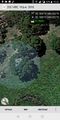
GPS proof :)
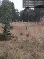
Kangaroo @-35.1846,149.0527
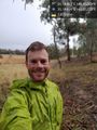
Me at the hash @-35.1846,149.0527
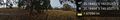
Panorama! @-35.1846,149.0527
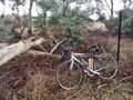
Bike near hash


Achievements
Felix Dance earned the Bicycle geohash achievement
|