Difference between revisions of "2018-06-19 48 7"
imported>LeslieHapablap (→Achievements) |
imported>FippeBot m (Location) |
||
| (3 intermediate revisions by 2 users not shown) | |||
| Line 15: | Line 15: | ||
}} | }} | ||
| − | + | ||
__NOTOC__ | __NOTOC__ | ||
== Location == | == Location == | ||
| − | + | ||
In a forest near Gottenheim. | In a forest near Gottenheim. | ||
== Participants == | == Participants == | ||
| − | + | ||
| − | + | * [[User:LeslieHapablap|LeslieHapablap]], ([[2018-04-28 47 7|previous]]|next) | |
| − | * [[User:LeslieHapablap|LeslieHapablap]], ([[2018- | ||
* [[User:LeslieHapablap/Waltraud|Waltraud]] the hashkiwi | * [[User:LeslieHapablap/Waltraud|Waltraud]] the hashkiwi | ||
== Plans == | == Plans == | ||
| − | + | ||
The plan was to go in and out in the evening, between two football matches of the World Cup. | The plan was to go in and out in the evening, between two football matches of the World Cup. | ||
== Expedition == | == Expedition == | ||
| − | |||
| − | |||
| − | It was a really pleasant evening, getting there by bike was no problem. However, the last 60 m were a torment: thicket, thorns, nettles, mud and swarms of mosquitoes. The obligatory | + | Only 3.5 km away from home, this should be easy I thought... But I learned the hard way that this point clearly did not want to be geohashed. |
| + | |||
| + | It was a really pleasant evening, getting there by bike was no problem. However, the last 60 m were a torment: thicket, | ||
| + | thorns, nettles, mud and swarms of mosquitoes. The obligatory GPS dance literally was a dance this time, because as soon | ||
| + | as I stopped moving, the mosquitoes started to eat me alive. | ||
| + | |||
| + | After taking the GPS proof screenshot I just wanted to get out | ||
| + | of there as quickly as possible. Attempting this hash with short trousers was not the best of ideas. | ||
== Photos == | == Photos == | ||
| − | + | ||
| − | |||
| − | |||
<gallery perrow="5"> | <gallery perrow="5"> | ||
Image:2018-06-19_48_7_LeslieHapablap_1529530486080.jpg|What a nice evening. | Image:2018-06-19_48_7_LeslieHapablap_1529530486080.jpg|What a nice evening. | ||
| − | |||
Image:2018-06-19_48_7_LeslieHapablap_1529530537524.jpg|Starting with [[User:LeslieHapablap/Waltraud|Waltraud]] the hashkiwi. | Image:2018-06-19_48_7_LeslieHapablap_1529530537524.jpg|Starting with [[User:LeslieHapablap/Waltraud|Waltraud]] the hashkiwi. | ||
| − | |||
Image:2018-06-19_48_7_LeslieHapablap_1529530563295.jpg|Arriving near the point: 60m into this jungle :( | Image:2018-06-19_48_7_LeslieHapablap_1529530563295.jpg|Arriving near the point: 60m into this jungle :( | ||
| − | |||
Image:2018-06-19_48_7_LeslieHapablap_1529530604422.jpg|Obligatory proof. | Image:2018-06-19_48_7_LeslieHapablap_1529530604422.jpg|Obligatory proof. | ||
| − | |||
Image:2018-06-19_48_7_LeslieHapablap_1529530631994.jpg|The hashpoint. | Image:2018-06-19_48_7_LeslieHapablap_1529530631994.jpg|The hashpoint. | ||
| − | |||
Image:2018-06-19_48_7_LeslieHapablap_1529530650495.jpg|The hashpoint. | Image:2018-06-19_48_7_LeslieHapablap_1529530650495.jpg|The hashpoint. | ||
</gallery> | </gallery> | ||
| Line 59: | Line 56: | ||
== Achievements == | == Achievements == | ||
{{#vardefine:ribbonwidth|800px}} | {{#vardefine:ribbonwidth|800px}} | ||
| − | + | ||
{{land geohash | {{land geohash | ||
| − | | latitude = | + | | latitude = 48 |
| longitude = 7 | | longitude = 7 | ||
| date = 2018-06-19 | | date = 2018-06-19 | ||
| Line 71: | Line 68: | ||
{{bicycle geohash | {{bicycle geohash | ||
| − | | latitude = | + | | latitude = 48 |
| longitude = 7 | | longitude = 7 | ||
| date = 2018-06-19 | | date = 2018-06-19 | ||
| Line 79: | Line 76: | ||
}} | }} | ||
| − | |||
| − | |||
| − | |||
| − | |||
| − | |||
| − | |||
| − | |||
| − | |||
| − | |||
| − | |||
| − | |||
| − | |||
| − | |||
| − | |||
| − | |||
| − | |||
| − | |||
[[Category:Expeditions]] | [[Category:Expeditions]] | ||
[[Category:Expeditions with photos]] | [[Category:Expeditions with photos]] | ||
[[Category:Coordinates reached]] | [[Category:Coordinates reached]] | ||
| − | + | {{location|DE|BW|FR}} | |
| − | |||
| − | |||
| − | |||
| − | |||
| − | |||
| − | |||
| − | |||
| − | |||
| − | |||
| − | |||
| − | |||
| − | |||
| − | |||
| − | |||
| − | |||
| − | |||
| − | |||
| − | |||
| − | |||
| − | |||
Latest revision as of 03:08, 7 August 2019
| Tue 19 Jun 2018 in 48,7: 48.0528012, 7.7402279 geohashing.info google osm bing/os kml crox |
Location
In a forest near Gottenheim.
Participants
- LeslieHapablap, (previous|next)
- Waltraud the hashkiwi
Plans
The plan was to go in and out in the evening, between two football matches of the World Cup.
Expedition
Only 3.5 km away from home, this should be easy I thought... But I learned the hard way that this point clearly did not want to be geohashed.
It was a really pleasant evening, getting there by bike was no problem. However, the last 60 m were a torment: thicket, thorns, nettles, mud and swarms of mosquitoes. The obligatory GPS dance literally was a dance this time, because as soon as I stopped moving, the mosquitoes started to eat me alive.
After taking the GPS proof screenshot I just wanted to get out of there as quickly as possible. Attempting this hash with short trousers was not the best of ideas.
Photos
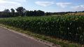
What a nice evening.
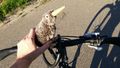
Starting with Waltraud the hashkiwi.
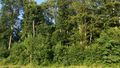
Arriving near the point: 60m into this jungle :(
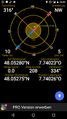
Obligatory proof.
The hashpoint.
The hashpoint.


Achievements
LeslieHapablap earned the Land geohash achievement
|
LeslieHapablap earned the Bicycle geohash achievement
|