Difference between revisions of "2018-07-15 31 34"
From Geohashing
imported>Dubdub (→Participants) |
imported>FippeBot m (Location) |
||
| (15 intermediate revisions by 4 users not shown) | |||
| Line 10: | Line 10: | ||
--> | --> | ||
{{meetup graticule | {{meetup graticule | ||
| + | | map=<map lat="31" lon="34" date="2018-07-15" /> | ||
| lat=31 | | lat=31 | ||
| lon=34 | | lon=34 | ||
| Line 15: | Line 16: | ||
}} | }} | ||
| − | + | ||
__NOTOC__ | __NOTOC__ | ||
== Location == | == Location == | ||
| − | + | ||
The point fell in the south-most side of Rehovot. | The point fell in the south-most side of Rehovot. | ||
== Participants == | == Participants == | ||
| − | + | ||
| − | + | * [[User:Dubdub|Dubdub]] | |
| − | [[User:Dubdub|Dubdub]] | + | * [[User:Jordy|Jordy]] |
== Plans == | == Plans == | ||
| − | + | ||
The plan was to advance through Tel Aviv to Rehovot using public transport. | The plan was to advance through Tel Aviv to Rehovot using public transport. | ||
| Line 40: | Line 41: | ||
*Near Azrielli Towers, still a plenty of time ahead 32.09038330°N 34.79260670°E -- [[User:Dubdub|Dubdub]] ([[User talk:Dubdub|talk]]) 18:48, 15 July 2018 (GMT+03:00) | *Near Azrielli Towers, still a plenty of time ahead 32.09038330°N 34.79260670°E -- [[User:Dubdub|Dubdub]] ([[User talk:Dubdub|talk]]) 18:48, 15 July 2018 (GMT+03:00) | ||
| + | |||
| + | *On Rishon LeTsion, starting to get closer -- [[User:Dubdub|Dubdub]] ([[User talk:Dubdub|talk]]) 19:14, 15 July 2018 (GMT+03:00) | ||
| + | |||
| + | *On Rechovot, eating in a good pasta resturant on our way [[User:Jordy|Jordy]] ([[User talk:Jordy|talk]]) 17:33, 15 July 2018 (UTC) | ||
| + | |||
| + | *Finally did it! [[User:Dubdub|Dubdub]] ([[User talk:Dubdub|talk]]) 18:10, 15 July 2018 (UTC) | ||
| + | |||
== Tracklog == | == Tracklog == | ||
<!-- if your GPS device keeps a log, you may post a link here --> | <!-- if your GPS device keeps a log, you may post a link here --> | ||
| Line 47: | Line 55: | ||
Image:2012-##-## ## ## Alpha.jpg | Witty Comment | Image:2012-##-## ## ## Alpha.jpg | Witty Comment | ||
--> | --> | ||
| − | <gallery perrow=" | + | <gallery perrow="4"> |
Image:2018-07-15_31_34_Dubdub_1531668554826.jpg|Tel Aviv bus station | Image:2018-07-15_31_34_Dubdub_1531668554826.jpg|Tel Aviv bus station | ||
| + | Image:2018-07-15 31 34 Jordy 1531668554826.jpg | Path | ||
| + | |||
| + | Image:2018-07-15_31_34_Dubdub_1531672551362.jpg|Finally the entrance to Rehovot. But the north side, so we have to cross the city | ||
| + | |||
| + | Image:2018-07-15_31_34_Dubdub_1531677210632.jpg|Havatselet neighborhood | ||
| + | |||
| + | Image:2018-07-15_31_34_Dubdub_1531677515707.jpg|We did it! | ||
| + | |||
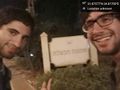
| + | Image:2018-07-15_31_34_Dubdub_1531678509704.jpg|Geohash selfie | ||
| + | |||
| + | Image:2018-07-15_31_34_Dubdub_1531678543909.jpg|Luckiky it fell right inside a public garden | ||
</gallery> | </gallery> | ||
| Line 58: | Line 77: | ||
<!-- =============== USEFUL CATEGORIES FOLLOW ================ | <!-- =============== USEFUL CATEGORIES FOLLOW ================ | ||
Delete the next line ONLY if you have chosen the appropriate categories below. If you are unsure, don't worry. People will read your report and help you with the classification. --> | Delete the next line ONLY if you have chosen the appropriate categories below. If you are unsure, don't worry. People will read your report and help you with the classification. --> | ||
| − | |||
<!-- ==REQUEST FOR TWITTER BOT== Please leave either the New report or the Expedition planning category in as long as you work on it. This helps the twitter bot a lot with announcing the right outcome at the right moment. --> | <!-- ==REQUEST FOR TWITTER BOT== Please leave either the New report or the Expedition planning category in as long as you work on it. This helps the twitter bot a lot with announcing the right outcome at the right moment. --> | ||
| Line 77: | Line 95: | ||
--> | --> | ||
| − | <!-- if you reached your coords: | + | <!-- if you reached your coords: --> |
| + | [[Category:Expeditions]] | ||
[[Category:Coordinates reached]] | [[Category:Coordinates reached]] | ||
| + | [[Category:Expeditions with photos]] | ||
| − | + | <!-- or if you failed :( | |
[[Category:Coordinates not reached]] | [[Category:Coordinates not reached]] | ||
-- and a reason -- | -- and a reason -- | ||
| Line 97: | Line 117: | ||
(Don't forget to delete this final close comment marker) --> | (Don't forget to delete this final close comment marker) --> | ||
| + | {{location|IL|M|RH}} | ||
Latest revision as of 12:35, 14 July 2019
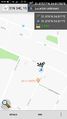
| Sun 15 Jul 2018 in 31,34: 31.8757748, 34.8170045 geohashing.info google osm bing/os kml crox |
Location
The point fell in the south-most side of Rehovot.
Participants
Plans
The plan was to advance through Tel Aviv to Rehovot using public transport.
Expedition
- Near Azrielli Towers, still a plenty of time ahead 32.09038330°N 34.79260670°E -- Dubdub (talk) 18:48, 15 July 2018 (GMT+03:00)
Tracklog
Photos
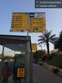
Tel Aviv bus station
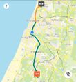
Path
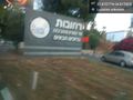
Finally the entrance to Rehovot. But the north side, so we have to cross the city
Havatselet neighborhood
We did it!
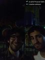
Geohash selfie
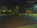
Luckiky it fell right inside a public garden


