Difference between revisions of "2008-05-31 33 -117"
imported>Scerruti (→Story: Recovered story from lost blog post.) |
imported>Scerruti (Added Virgin graticule ribbon) |
||
| Line 24: | Line 24: | ||
[[Image:Blurry-us-small.jpg]] | [[Image:Blurry-us-small.jpg]] | ||
| + | == Awards == | ||
| + | {{Virgin graticule | ||
| + | | latitude = 33 | ||
| + | | longitude = -117 | ||
| + | | date = 2008-05-31 | ||
| + | | name = mooseydoom and Kristi | ||
| + | }} | ||
[[Category:Expeditions]] | [[Category:Expeditions]] | ||
[[Category:Expeditions with photos]] | [[Category:Expeditions with photos]] | ||
[[Category:Coordinates reached]] | [[Category:Coordinates reached]] | ||
Revision as of 06:53, 10 May 2012
| Sat 31 May 2008 in 33,-117: 33.0374871, -117.2812665 geohashing.info google osm bing/os kml crox |
Story
A blog post about our trip -- This link is no longer working. I used the Wayback Machine to recover the text of the expedition unfortunately I was unable to recover the images. Stephen Cerruti 02:49, 10 May 2012 (EDT)
So following xkcd’s geohash algorithm, we went out to Encinitas to hit our point for Saturday.
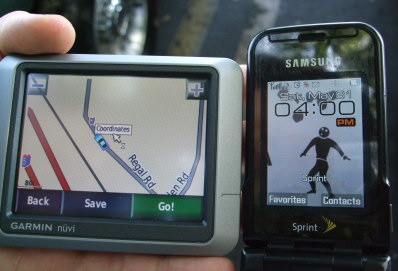
Side story: We left home at around 2:45PM to Fry’s since Kristi’s Garmin (GPS) didn’t display coordinates. We got to Fry’s probably around 3:15 to pick up a GPS that showed coordinates. (Garmin Nuvi 200!!) Anyway, we were able to get to the front of the Fry’s line (it was around 3:30 and we still needed to get to Encinitas at 4:00PM for the scheduled meeting time - around 15 miles away) thanks to the badass Fry’s salesman that sold me the Nuvi after I told him we were in a rush. We ended up making it to the meetup point in Encinitas at 3:58 and got pictures at exactly 4:00PM. So the Hero of the Day award goes to the nameless Fry’s salesman.
Pictures!
This picture was taken exactally at 4:00. When I pushed the trigger of the camera the screen showed 3:59, but the picture recorded 4:00.
Special thanks to the four wheeled tripod which was parked next to us.

