Difference between revisions of "2018-08-25 49 8"
imported>DODO ([live] Stil there, saturday meetup. Alone, again.) |
imported>DODO |
||
| Line 20: | Line 20: | ||
== Location == | == Location == | ||
<!-- where you've surveyed the hash to be --> | <!-- where you've surveyed the hash to be --> | ||
| − | + | An asparagus field near Hockenheim | |
== Participants == | == Participants == | ||
<!-- who attended: If you link to your wiki user name in this section, your expedition will be picked up by the various statistics generated for geohashing. You may use three tildes ~ as a shortcut to automatically insert the user signature of the account you are editing with. | <!-- who attended: If you link to your wiki user name in this section, your expedition will be picked up by the various statistics generated for geohashing. You may use three tildes ~ as a shortcut to automatically insert the user signature of the account you are editing with. | ||
| Line 31: | Line 31: | ||
<!-- how it all turned out. your narrative goes here. --> | <!-- how it all turned out. your narrative goes here. --> | ||
| + | I started the ride at 15:15 on my bike. The wind blew from the rear and I was pretty fast. I've choosen an unusual way through the town as I wanted to try a tron once again and I found some new pathes close to home. It's alwas worth to go hashing. I reached Hockenheim after half an hour and left it again into the fields five minutes later. To my surprise there were several velicoraptors flying in the air over the field next to the hashfield, having strange colors and even stranger shapes. But I had a hash to reach, and so I just passed them. It seems that they didn't follow me, and after I turned left twice I reached tha hashfield from the other side again. | ||
| + | The hash was located at the edge of an asparagus field, not sure wether it is inside or outside. But my instict let me walk into the field just behind the first row of asparagus and this time my instict was perfectly right. 35 m further I had a perfect shot. I took some pictures (the raptors once again), and returned to my bike. Here I waited for some minutes until it was hash o'clock, but noone else appeared. | ||
| − | + | For my way back I had to cross Hockenheim once again. Just at the beginnig of the town I passed the Pumpwerk, ayouth- and cultural centre where I visited a concert of [http://www.paddy.de/ Paddy goes to holyhead] last year, but it was 700 m from the hash, and so it won't qualify me for the deja vu, and I have no proof anyway. At the other side of the town I had to cross a railway. When I came close to it, I realized, that the planned route cross the railway over a bridge with a circled ramp, what would invalidate my tron. But to my relief, my phone showed me, that there is another bridge 600 m further down the road, and so I could save the tron by riding 1 KM more. A short time later, I had to realize, that the raptors had realized me. All of a sudden one of them attact me, flied against my forehead, fell behin my glasses and stung me, just below my left eye. Ouch. That stil hurts. A short time later it started to rain, and the wind now comes from the front of course, but nevertheless I came home soon and had a nice ride for a saturday afternoon. | |
| − | |||
| − | |||
| − | |||
== Tracklog == | == Tracklog == | ||
<!-- if your GPS device keeps a log, you may post a link here --> | <!-- if your GPS device keeps a log, you may post a link here --> | ||
| − | + | [https://www.komoot.de/tour/43918618 29 KM by bike] | |
== Photos == | == Photos == | ||
<!-- Insert pictures between the gallery tags using the following format: | <!-- Insert pictures between the gallery tags using the following format: | ||
| Line 45: | Line 44: | ||
--> | --> | ||
<gallery perrow="5"> | <gallery perrow="5"> | ||
| + | Image:2018-08-25_49_8-1.jpg|raptors near the hashpoint | ||
| + | Image:2018-08-25_49_8-2.jpg|my bike (proof of transport) | ||
| + | Image:2018-08-25_49_8-8.jpg|view to the hash. It's in the first line between the asparagus plants | ||
| + | Image:2018-08-25_49_8-11.jpg|proof | ||
| + | Image:2018-08-25_49_8-3.jpg|view from hash to the south and the raptors | ||
| + | Image:2018-08-25_49_8-4.jpg|view to the north. You can see the bike at the end of the last line of plants | ||
| + | Image:2018-08-25_49_8-5.jpg|View to east and west is pretty much the same: asparagus | ||
| + | Image:2018-08-25_49_8-6.jpg|view to the hasher | ||
| + | Image:2018-08-25_49_8-9.jpg|pumpwerk | ||
| + | Image:2018-08-25_49_8-10.jpg|raptor mark: a swollen eye | ||
</gallery> | </gallery> | ||
| Line 51: | Line 60: | ||
<!-- Add any achievement ribbons you earned below, or remove this section --> | <!-- Add any achievement ribbons you earned below, or remove this section --> | ||
| − | + | {{land geohash | |
| − | + | | latitude = 49 | |
| − | + | | longitude = 8 | |
| + | | date = 2018-08-25 | ||
| + | | name = DODO | ||
| + | }} | ||
| − | + | {{bicycle geohash | |
| + | | latitude = 49 | ||
| + | | longitude = 8 | ||
| + | | date = 2018-08-25 | ||
| + | | name = DODO | ||
| + | | distance = 29 KM | ||
| + | }} | ||
| − | + | {{Template:Tron | |
| − | + | | latitude = 49 | |
| − | + | | longitude = 8 | |
| − | + | | date = 2018-08-25 | |
| + | | name = DODO | ||
| + | | tracklog = https://www.komoot.de/tour/43918618 | ||
| + | | possessive = his | ||
| + | }} | ||
| − | + | {{Velociraptor geohash | |
| + | | latitude = 49 | ||
| + | | longitude = 8 | ||
| + | | date = 2018-08-25 | ||
| + | | name = DODO | ||
| + | }} | ||
| − | |||
[[Category:Expeditions]] | [[Category:Expeditions]] | ||
| − | |||
| − | |||
| − | |||
| − | |||
| − | |||
| − | |||
| − | |||
[[Category:Coordinates reached]] | [[Category:Coordinates reached]] | ||
| − | |||
| − | |||
| − | |||
| − | |||
| − | |||
| − | |||
| − | |||
| − | |||
| − | |||
| − | |||
| − | |||
| − | |||
| − | |||
| − | |||
| − | |||
| − | |||
| − | |||
| − | |||
Revision as of 16:34, 25 August 2018
| Sat 25 Aug 2018 in 49,8: 49.3123594, 8.5741791 geohashing.info google osm bing/os kml crox |
Location
An asparagus field near Hockenheim
Participants
Plans
Try to be there at hash o'clock. -- DODO (talk) 15:00, 25 August 2018 (GMT+02:00)
Expedition
I started the ride at 15:15 on my bike. The wind blew from the rear and I was pretty fast. I've choosen an unusual way through the town as I wanted to try a tron once again and I found some new pathes close to home. It's alwas worth to go hashing. I reached Hockenheim after half an hour and left it again into the fields five minutes later. To my surprise there were several velicoraptors flying in the air over the field next to the hashfield, having strange colors and even stranger shapes. But I had a hash to reach, and so I just passed them. It seems that they didn't follow me, and after I turned left twice I reached tha hashfield from the other side again.
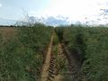
The hash was located at the edge of an asparagus field, not sure wether it is inside or outside. But my instict let me walk into the field just behind the first row of asparagus and this time my instict was perfectly right. 35 m further I had a perfect shot. I took some pictures (the raptors once again), and returned to my bike. Here I waited for some minutes until it was hash o'clock, but noone else appeared.
For my way back I had to cross Hockenheim once again. Just at the beginnig of the town I passed the Pumpwerk, ayouth- and cultural centre where I visited a concert of Paddy goes to holyhead last year, but it was 700 m from the hash, and so it won't qualify me for the deja vu, and I have no proof anyway. At the other side of the town I had to cross a railway. When I came close to it, I realized, that the planned route cross the railway over a bridge with a circled ramp, what would invalidate my tron. But to my relief, my phone showed me, that there is another bridge 600 m further down the road, and so I could save the tron by riding 1 KM more. A short time later, I had to realize, that the raptors had realized me. All of a sudden one of them attact me, flied against my forehead, fell behin my glasses and stung me, just below my left eye. Ouch. That stil hurts. A short time later it started to rain, and the wind now comes from the front of course, but nevertheless I came home soon and had a nice ride for a saturday afternoon.
Tracklog
Photos
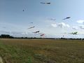
raptors near the hashpoint

my bike (proof of transport)
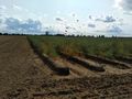
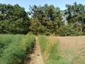
view to the hash. It's in the first line between the asparagus plants
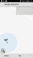
proof
view from hash to the south and the raptors
view to the north. You can see the bike at the end of the last line of plants
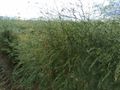
View to east and west is pretty much the same: asparagus
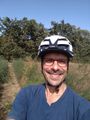
view to the hasher
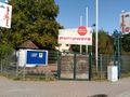
pumpwerk
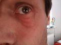
raptor mark: a swollen eye


Achievements
DODO earned the Land geohash achievement
|
DODO earned the Bicycle geohash achievement
|
DODO earned the Tron achievement
|
DODO earned the Velociraptor Geohash Achievement
|