Difference between revisions of "2018-11-03 49 8"
imported>DODO (→Plans) |
imported>FippeBot m (Location) |
||
| (4 intermediate revisions by one other user not shown) | |||
| Line 33: | Line 33: | ||
== Expedition == | == Expedition == | ||
<!-- how it all turned out. your narrative goes here. --> | <!-- how it all turned out. your narrative goes here. --> | ||
| + | I had a nicre ride in nice weather. Of course I tried to gain a tron achievement again, but when I came close to the ammunition depot, I took a wrong turn. And as the right turn was on the other side of a ditch, I couldn't correct my mistake. But at least, the choosem way was slightly shorter. In the middle of the forest there is a wide open space with some camouflaged buildings. Really a lost place, I wouldn't have found without hashing. But to my surprise, Ididn't hve to enter the area, the hash was 100 minto the forest on the other (right) side of my way. It was secured by a dense copde, and when I found a trail into it, it was marked with some bones. Hey, Halloween is over. | ||
| + | |||
| + | Nevertheless I fought my way through the thicketand soon reached a light forest. Quickly I managed the left 80 m, took some pictures and after some difficulties, to find back the trail, I reached my bike again. On my way home (although I missed the tron, I choose the longer way I'd planned), I found an ice vendor and had some nice cake (but forgot to photograph it, as I wasn't alone at my table). After 2 1/2 hours I reached home again. | ||
== Tracklog == | == Tracklog == | ||
<!-- if your GPS device keeps a log, you may post a link here --> | <!-- if your GPS device keeps a log, you may post a link here --> | ||
| + | [https://www.komoot.de/tour/51111086 33,5 KM by bike] | ||
== Photos == | == Photos == | ||
| Line 41: | Line 45: | ||
Image:2012-##-## ## ## Alpha.jpg | Witty Comment | Image:2012-##-## ## ## Alpha.jpg | Witty Comment | ||
--> | --> | ||
| − | <gallery perrow=" | + | <gallery perrow="6"> |
| + | Image:2018-11-03_49_8-1.jpg|area of the ammunition depot | ||
| + | Image:2018-11-03_49_8-10.jpg|and some buildings | ||
| + | Image:2018-11-03_49_8-9.jpg|bike (proof of transport), you can see the tree with the jaw behind | ||
| + | Image:2018-11-03_49_8-8.jpg|jaw and trail | ||
| + | Image:2018-11-03_49_8-7.jpg|trail. trail? | ||
| + | Image:2018-11-03_49_8-11.jpg|proof | ||
| + | Image:2018-11-03_49_8-3.jpg|north | ||
| + | Image:2018-11-03_49_8-4.jpg|east | ||
| + | Image:2018-11-03_49_8-5.jpg|south | ||
| + | Image:2018-11-03_49_8-6.jpg|west | ||
| + | Image:2018-11-03_49_8-2.jpg|hasher (happy) | ||
</gallery> | </gallery> | ||
| Line 47: | Line 62: | ||
{{#vardefine:ribbonwidth|800px}} | {{#vardefine:ribbonwidth|800px}} | ||
<!-- Add any achievement ribbons you earned below, or remove this section --> | <!-- Add any achievement ribbons you earned below, or remove this section --> | ||
| + | {{land geohash | ||
| + | | latitude = 49 | ||
| + | | longitude = 8 | ||
| + | | date = 2018-11-03 | ||
| + | | name = DODO | ||
| + | }} | ||
| − | + | {{consecutive geohash | |
| − | + | | count = 2 | |
| − | + | | latitude = 49 | |
| + | | longitude = 8 | ||
| + | | date = 2018-11-03 | ||
| + | | name = DODO | ||
| + | }} | ||
| − | + | {{bicycle geohash | |
| + | | latitude = 49 | ||
| + | | longitude = 8 | ||
| + | | date = 2018-11-03 | ||
| + | | name = DODO | ||
| + | | distance = 34 KM | ||
| + | }} | ||
| − | |||
| − | |||
| − | |||
| − | |||
| − | |||
| − | |||
| − | |||
| − | |||
[[Category:Expeditions]] | [[Category:Expeditions]] | ||
| − | |||
| − | |||
| − | |||
| − | |||
| − | |||
| − | |||
| − | |||
[[Category:Coordinates reached]] | [[Category:Coordinates reached]] | ||
| − | + | {{location|DE|BW|KA}} | |
| − | |||
| − | |||
| − | |||
| − | |||
| − | |||
| − | |||
| − | |||
| − | |||
| − | |||
| − | |||
| − | |||
| − | |||
| − | |||
| − | |||
| − | |||
| − | |||
| − | |||
Latest revision as of 04:14, 16 August 2019
| Sat 3 Nov 2018 in 49,8: 49.2645585, 8.5462871 geohashing.info google osm bing/os kml crox |
Location
In the forest near Kirrlach. Next to a former ammunition depot.
Participants
Plans
I'll start with my bike at 11:30. The ride will take me - hopefully - less than an hour. So I will arrive around 12:15.
Expedition
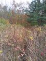
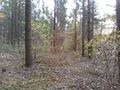
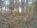
I had a nicre ride in nice weather. Of course I tried to gain a tron achievement again, but when I came close to the ammunition depot, I took a wrong turn. And as the right turn was on the other side of a ditch, I couldn't correct my mistake. But at least, the choosem way was slightly shorter. In the middle of the forest there is a wide open space with some camouflaged buildings. Really a lost place, I wouldn't have found without hashing. But to my surprise, Ididn't hve to enter the area, the hash was 100 minto the forest on the other (right) side of my way. It was secured by a dense copde, and when I found a trail into it, it was marked with some bones. Hey, Halloween is over.
Nevertheless I fought my way through the thicketand soon reached a light forest. Quickly I managed the left 80 m, took some pictures and after some difficulties, to find back the trail, I reached my bike again. On my way home (although I missed the tron, I choose the longer way I'd planned), I found an ice vendor and had some nice cake (but forgot to photograph it, as I wasn't alone at my table). After 2 1/2 hours I reached home again.
Tracklog
Photos
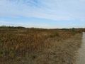
area of the ammunition depot
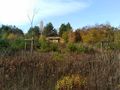
and some buildings
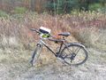
bike (proof of transport), you can see the tree with the jaw behind
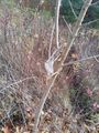
jaw and trail
trail. trail?

proof
north
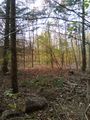
east
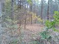
south
west

hasher (happy)


Achievements
DODO earned the Land geohash achievement
|
DODO earned the Consecutive geohash achievement
|
DODO earned the Bicycle geohash achievement
|