Difference between revisions of "2018-11-04 49 8"
imported>DODO (→Photos) |
imported>DODO (→Achievements) |
||
| Line 56: | Line 56: | ||
{{#vardefine:ribbonwidth|800px}} | {{#vardefine:ribbonwidth|800px}} | ||
<!-- Add any achievement ribbons you earned below, or remove this section --> | <!-- Add any achievement ribbons you earned below, or remove this section --> | ||
| + | {{land geohash | ||
| + | | latitude = 49 | ||
| + | | longitude = 8 | ||
| + | | date = 2018-11-04 | ||
| + | | name = DODO | ||
| + | }} | ||
| − | + | {{consecutive geohash | |
| − | + | | count = 3 | |
| − | + | | latitude = 49 | |
| + | | longitude = 8 | ||
| + | | date = 2018-11-02 | ||
| + | | name = DODO | ||
| + | }} | ||
| − | + | {{bicycle geohash | |
| + | | latitude = 49 | ||
| + | | longitude = 8 | ||
| + | | date = 2018-11-04 | ||
| + | | name = DODO | ||
| + | | distance = 48 KM | ||
| + | }} | ||
| − | |||
| − | |||
| − | |||
| − | |||
| − | |||
| − | |||
| − | |||
| − | |||
[[Category:Expeditions]] | [[Category:Expeditions]] | ||
| − | |||
| − | |||
| − | |||
| − | |||
| − | |||
| − | |||
| − | |||
[[Category:Coordinates reached]] | [[Category:Coordinates reached]] | ||
| − | |||
| − | |||
| − | |||
| − | |||
| − | |||
| − | |||
| − | |||
| − | |||
| − | |||
| − | |||
| − | |||
| − | |||
| − | |||
| − | |||
| − | |||
| − | |||
| − | |||
| − | |||
Revision as of 14:06, 4 November 2018
| Sun 4 Nov 2018 in 49,8: 49.0542181, 8.2087338 geohashing.info google osm bing/os kml crox |
Location
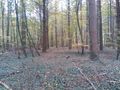
In the forest south of Kandel, near the french border.
Participants
Plans
Go there by bike in the morning.
Expedition
I started at home at 10 o'clock. I rode southwards, what was nice, since we had a slight wind from the north. I rode through Römerberg, Lingenfeld, Germersheim, Sondernheim, Hördt, Rülzheim and Rheinzabern, and finally reached Kandel after one and a half hour. After Kandel I had to follow the B9, a national road that leads from the Autobahn to France and is very frequented. Luckily it was sunday today, so there were no trucks at least. It was only for 2 KM but I didn't feel well there. Then I turned left, and some minutes later I was as close to the hash as a path could lead me. I parked my bike and walked the remaining 100 m into the forest. No thicket today, so this part was easy. Five minutes later I was back at my bike and rode the remaining 6 KM to Wörth, where I took the train back home. All in all the trip took me 3 1/2 hours.
Tracklog
48 KM by bike and 41 KM by train
Photos
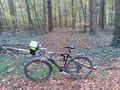
bike (transport)

proof
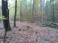
west
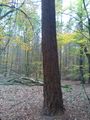
Hashtree
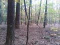
north
east, all almost the same
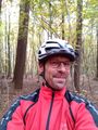
happy hasher


Achievements
DODO earned the Land geohash achievement
|
DODO earned the Consecutive geohash achievement
|
DODO earned the Bicycle geohash achievement
|