Difference between revisions of "2018-12-23 51 9"
From Geohashing
imported>GeorgDerReisende (new report) |
imported>GeorgDerReisende (expedition report for Bad Emstal-Sand) |
||
| Line 1: | Line 1: | ||
| − | |||
| − | |||
| − | |||
| − | |||
| − | |||
| − | |||
| − | |||
| − | |||
| − | |||
| − | |||
{{meetup graticule | {{meetup graticule | ||
| lat=51 | | lat=51 | ||
| Line 19: | Line 9: | ||
== Location == | == Location == | ||
| − | + | ||
| + | The hash lay at the edge of the forest west of Bad-Emstal-Sand. | ||
== Participants == | == Participants == | ||
| − | + | ||
| − | + | [[User:GeorgDerReisende|GeorgDerReisende]] | |
== Plans == | == Plans == | ||
| − | + | ||
| + | Travel by bus and walking. | ||
== Expedition == | == Expedition == | ||
| − | |||
| − | + | The most exciting problem of the journey was to find the platform, where the bus 53 leaves the Wilhelmshöhe railway station. At least I found it, but there was no timetable for buses to Bad Emstal. In Bad Emstal I walked 1.5 kilometers to the hash. It was marked with a orange stick. | |
| − | |||
== Photos == | == Photos == | ||
| − | |||
| − | |||
| − | |||
<gallery perrow="5"> | <gallery perrow="5"> | ||
| + | 2018-12-23 51 9 GeorgDerReisende 3213.jpg | I arrived and the bus went on | ||
| + | 2018-12-23 51 9 GeorgDerReisende 3232.jpg | the hash was ten meters left to the shed | ||
| + | 2018-12-23 51 9 GeorgDerReisende 3241.jpg | the hash was at the orange stick | ||
| + | 2018-12-23 51 9 GeorgDerReisende 3244.jpg | proof | ||
| + | 2018-12-23 51 9 GeorgDerReisende 3245.jpg | the north | ||
| + | 2018-12-23 51 9 GeorgDerReisende 3246.jpg | the east | ||
| + | 2018-12-23 51 9 GeorgDerReisende 3247.jpg | the south | ||
| + | 2018-12-23 51 9 GeorgDerReisende 3248.jpg | the west | ||
| + | 2018-12-23 51 9 GeorgDerReisende 3249.jpg | the geohasher | ||
| + | 2018-12-23 51 9 GeorgDerReisende 3252.jpg | a last glance to the hash | ||
</gallery> | </gallery> | ||
| − | + | [[Category:Expeditions]] | |
| − | |||
| − | |||
| − | + | [[Category:Expeditions with photos]] | |
| − | |||
| − | [[Category: | ||
| − | |||
| − | |||
| − | |||
| − | |||
| − | |||
| − | |||
| − | |||
| − | |||
| − | |||
| − | |||
| − | |||
| − | |||
| − | |||
| − | |||
| − | |||
| − | |||
| − | |||
| − | |||
| − | |||
| − | |||
[[Category:Coordinates reached]] | [[Category:Coordinates reached]] | ||
| − | |||
| − | |||
| − | |||
| − | |||
| − | |||
| − | |||
| − | |||
| − | |||
| − | |||
| − | |||
| − | |||
| − | |||
| − | |||
| − | |||
| − | |||
| − | |||
| − | |||
| − | |||
Revision as of 20:18, 24 December 2018
| Sun 23 Dec 2018 in 51,9: 51.2411564, 9.2427673 geohashing.info google osm bing/os kml crox |
Location
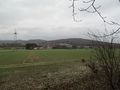
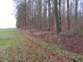
The hash lay at the edge of the forest west of Bad-Emstal-Sand.
Participants
Plans
Travel by bus and walking.
Expedition
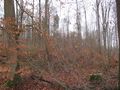
The most exciting problem of the journey was to find the platform, where the bus 53 leaves the Wilhelmshöhe railway station. At least I found it, but there was no timetable for buses to Bad Emstal. In Bad Emstal I walked 1.5 kilometers to the hash. It was marked with a orange stick.
Photos
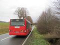
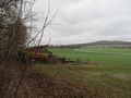
I arrived and the bus went on
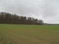
the hash was ten meters left to the shed
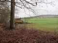
the hash was at the orange stick
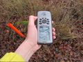
proof
the north
the east
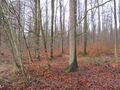
the south
the west
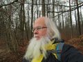
the geohasher
a last glance to the hash


